
-
Federal
HANPP Collection: Human Appropriation of Net Primary Productivity as a Percentage of Net Primary Productivity
National Aeronautics and Space Administration —
The HANPP Collection: Human Appropriation of Net Primary Productivity as a Percentage of Net Primary Productivity represents a map identifying regions in which human... -
Federal
Global Flood Hazard Frequency and Distribution
National Aeronautics and Space Administration —
The Global Flood Hazard Frequency and Distribution is a 2.5 minute grid derived from a global listing of extreme flood events between 1985 and 2003 (poor or missing... -
Federal
USGS Digital Orthophoto Quadrangles
National Aeronautics and Space Administration —
A Digital Orthophoto Quadrangle (DOQ) is a computer-generated image of an aerial photograph in which the image displacement caused by terrain relief and camera tilt... -
Federal
HANPP Collection: Global Patterns in Human Appropriation of Net Primary Productivity (HANPP)
National Aeronautics and Space Administration —
The HANPP Collection: Global Patterns in Human Appropriation of Net Primary Productivity (HANPP) represents a digital map of human appropriation of net primary... -
Federal
Pilot 2006 Environmental Performance Index (EPI)
National Aeronautics and Space Administration —
The Pilot 2006 Environmental Performance Index (EPI) centers on two broad environmental protection objectives: (1) reducing environmental stresses on human health,... -
Federal
Global Estimated Net Migration Grids by Decade: 1970-2000
National Aeronautics and Space Administration —
The Global Estimated Net Migration by Decade: 1970-2000 data set provides estimates of net migration over the three decades from 1970 to 2000. Because of the lack of... -
Federal
IceBridge ZLS Dynamic Gravity Meter Time-Registered L1B Vertical Accelerations V001
National Aeronautics and Space Administration —
This data set contains vertical, cross body, and along body acceleration values for geophysical survey flights in Antarctica using the ZLS Dynamic Gravity Meter. The... -
Federal
2008 Environmental Performance Index (EPI)
National Aeronautics and Space Administration —
The 2008 Environmental Performance Index (EPI) centers on two broad environmental protection objectives: (1) reducing environmental stresses on human health, and (2)... -
Federal
HANPP Collection: Global Patterns in Net Primary Productivity (NPP)
National Aeronautics and Space Administration —
The HANPP Collection: Global Patterns in Net Primary Productivity (NPP) maps the net amount of solar energy converted to plant organic matter through photosynthesis.... -
Federal
IceBridge Photon Counting Lidar L1B Subset Geolocated Photon Elevations V001
National Aeronautics and Space Administration —
This data set contains nadir photon counting data captured over Antarctica using the Sigma Space photon counting lidar. Position and orientation data are included.... -
Federal
HANPP Collection: Human Appropriation of Net Primary Productivity (HANPP) by Country and Product
National Aeronautics and Space Administration —
The HANPP Collection: Human Appropriation of Net Primary Productivity (HANPP) by Country and Product contains tabular data on carbon-equivalents of consumption by... -
Federal
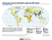
Anthropogenic Biomes of the World, Version 2: 2000
National Aeronautics and Space Administration —
The Anthropogenic Biomes of the World, Version 2: 2000 data set describes anthropogenic transformations within the terrestrial biosphere caused by sustained direct... -
Federal
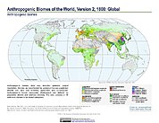
Anthropogenic Biomes of the World, Version 2: 1800
National Aeronautics and Space Administration —
The Anthropogenic Biomes of the World, Version 2: 1800 data set describes anthropogenic transformations within the terrestrial biosphere caused by sustained direct... -
Federal
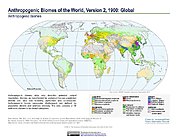
Anthropogenic Biomes of the World, Version 2: 1700
National Aeronautics and Space Administration —
The Anthropogenic Biomes of the World, Version 2: 1700 data set describes anthropogenic transformations within the terrestrial biosphere caused by sustained direct... -
Federal
Aerial Photographs (from AMES Pilot Land Data System); USGS EDC, Sioux Falls
National Aeronautics and Space Administration —
The aerial photography inventoried by the Pilot Land Data System (PLDS) at NASA AMES Research Center has been transferred to the USGS EROS Data Center. The photos... -
Federal
IceBridge Photon Counting Lidar L1B Unclassified Geolocated Photon Elevations V001
National Aeronautics and Space Administration —
This data set contains geolocated photon elevations captured over Antarctica using the Sigma Space photon counting lidar. The data were collected by scientists... -
Federal
IceBridge Merged Photon Counting Lidar/Profiler L4 Surface Slope and Elevations V001
National Aeronautics and Space Administration —
This data set contains geolocated surface elevation measurements captured over Antarctica using the Sigma Space Mapping Photon Counting Lidar and Riegl Laser... -
Federal
Anthropogenic Biomes of the World, Version 2: 1900
National Aeronautics and Space Administration —
The Anthropogenic Biomes of the World, Version 2: 1900 data set describes anthropogenic transformations within the terrestrial biosphere caused by sustained direct...

Official websites use .gov
A
.gov website belongs to an official government
organization in the United States.
Secure .gov websites use HTTPS
A
lock (
) or https:// means you’ve safely connected to
the .gov website. Share sensitive information only on official,
secure websites.