
-
Federal
Global Flood Hazard Frequency and Distribution recent views
National Aeronautics and Space Administration —
The Global Flood Hazard Frequency and Distribution is a 2.5 minute grid derived from a global listing of extreme flood events between 1985 and 2003 (poor or missing... -
Federal
Impacts of Wildfires on Boreal Forest Ecosystem Carbon Dynamics recent views
National Aeronautics and Space Administration —
This dataset contains simulations of net primary production (NPP), heterotrophic respiration (RH), net ecosystem production (NEP), and soil temperature data in North... -
Federal
GPCP Precipitation Level 3 Daily 0.5-Degree V3.2 (GPCPDAY) at GES DISC recent views
National Aeronautics and Space Administration —
Version 3.2 is the current version. Older versions have been superseded by Version 3.2. The Global Precipitation Climatology Project (GPCP) is the precipitation... -
Federal
2014 Environmental Performance Index (EPI) recent views
National Aeronautics and Space Administration —
The 2014 Environmental Performance Index (EPI) ranks 178 countries on 20 performance indicators in the following 9 policy categories: health impacts, air quality,... -
Federal
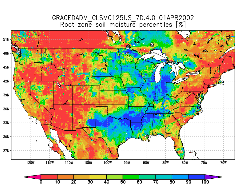
Groundwater and Soil Moisture Conditions from GRACE and GRACE-FO Data Assimilation L4 7-days 0.125 x 0.125 degree U.S. V4.0 (GRACEDADM_CLSM0125US_7D) at GES DISC recent views
National Aeronautics and Space Administration —
Scientists at NASA Goddard Space Flight Center generate groundwater and soil moisture drought indicators each week. They are based on terrestrial water storage... -
Federal
CERES Energy Balanced and Filled (EBAF) TOA and Surface Monthly means data in netCDF Edition 4.2 recent views
National Aeronautics and Space Administration —
CERES_EBAF_Edition4.2 is the Clouds and the Earth's Radiant Energy System (CERES) Energy Balanced and Filled (EBAF) Top-of-Atmosphere (TOA) and surface monthly means... -
Federal
CERES Monthly Gridded Single Satellite Fluxes and Clouds Aqua FM4 Edition2B recent views
National Aeronautics and Space Administration —
CER_FSW_Aqua-FM4-MODIS_Edition2B is the Clouds and the Earth's Radiant Energy System (CERES) Fixed Swath Width (FSW) Monthly Gridded Single Satellite Fluxes (SSF) and... -
Federal
HANPP Collection: Global Patterns in Net Primary Productivity (NPP) recent views
National Aeronautics and Space Administration —
The HANPP Collection: Global Patterns in Net Primary Productivity (NPP) maps the net amount of solar energy converted to plant organic matter through photosynthesis.... -
Federal
China Dimensions Data Collection: China County-Level Data from Provincial Economic Yearbooks, Keyed to 1:1M GIS Map recent views
National Aeronautics and Space Administration —
The China County-Level Data on Provincial Economic Yearbooks, Keyed To 1:1M GIS Map consists of socioeconomic and boundary data for the administrative regions of... -
Federal
ISLSCP II Ecosystem Rooting Depths NGDA recent views
National Aeronautics and Space Administration —
The goal of this study was to predict the global distribution of plant rooting depths based on data about global aboveground vegetation structure and climate.... -
Federal
MODIS/Aqua Total Precipitable Water Vapor 5-Min L2 Swath 1km and 5km NGDA recent views
National Aeronautics and Space Administration —
The MODIS/Aqua Total Precipitable Water Vapor 5-Min L2 Swath 1km and 5km (MYD05_L2) product consists of atmospheric column water-vapor amounts. This product is... -
Federal
GPM Ground Validation Global Flood Monitoring System (GFMS) Flood Maps IFloodS V1 recent views
National Aeronautics and Space Administration —
The GPM Ground Validation Global Flood Monitoring System (GFMS) Flood Maps IFloodS dataset contains global flood estimates on a 0.25 degree spatial resolution every 3... -
Federal
NLDAS Mosaic Land Surface Model L4 Hourly 0.125 x 0.125 degree V002 (NLDAS_MOS0125_H) at GES DISC recent views
National Aeronautics and Space Administration —
This data set contains a series of land surface parameters simulated from the Mosaic land-surface model (LSM) for Phase 2 of the North American Land Data Assimilation... -
Federal
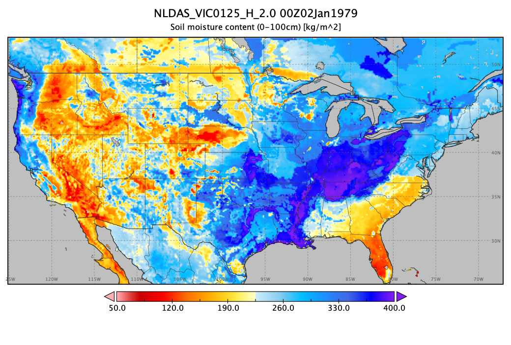
NLDAS VIC Land Surface Model L4 Hourly 0.125 x 0.125 degree V2.0 (NLDAS_VIC0125_H) at GES DISC recent views
National Aeronautics and Space Administration —
This data set contains forty-four fields simulated from the VIC land-surface model (LSM) for Phase 2 of the North American Land Data Assimilation System (NLDAS-2).... -
Federal
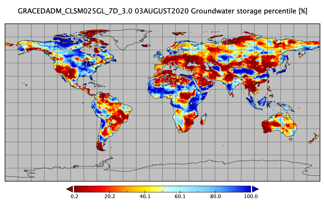
Groundwater and Soil Moisture Conditions from GRACE and GRACE-FO Data Assimilation L4 7-days 0.25 x 0.25 degree Global V3.0 (GRACEDADM_CLSM025GL_7D) at GES DISC recent views
National Aeronautics and Space Administration —
Scientists at NASA Goddard Space Flight Center generate groundwater and soil moisture drought indicators each week. They are based on terrestrial water storage... -
Federal
GPM GROUND VALIDATION AUTONOMOUS PARSIVEL UNIT (APU) MC3E V1 recent views
National Aeronautics and Space Administration —
The GPM Ground Validation Autonomous Parsivel Unit (APU) MC3E dataset was collected by the Autonomous Parsivel Unit (APU), which is an optical disdrometer that... -
Federal
GEDI L2A Elevation and Height Metrics Data Global Footprint Level V002 recent views
National Aeronautics and Space Administration —
The Global Ecosystem Dynamics Investigation (GEDI) mission aims to characterize ecosystem structure and dynamics to enable radically improved quantification and... -
Federal
SatCORPS CERES GEO Edition 4 Meteosat-9 Southern Hemisphere Version 1.0 recent views
National Aeronautics and Space Administration —
CER_GEO_Ed4_MET09_SH_V01 is the Satellite Cloud and Radiation Property retrieval System (SatCORPS) Clouds and the Earth's Radiant Energy System (CERES) Geostationary... -
Federal
Global Human Built-up And Settlement Extent (HBASE) Dataset From Landsat recent views
National Aeronautics and Space Administration —
The Global Human Built-up And Settlement Extent (HBASE) Dataset from Landsat is a global map of HBASE derived from the Global Land Survey (GLS) Landsat dataset for... -
Federal
GHRSST Level 2P Western Atlantic Regional Skin Sea Surface Temperature from the Geostationary Operational Environmental Satellites (GOES) Imager on the GOES-13 satellite (GDS version 2) recent views
National Aeronautics and Space Administration —
The Geostationary Operational Environmental Satellites (GOES) operated by the United States National Oceanic and Atmospheric Administration (NOAA) support weather...

Official websites use .gov
A
.gov website belongs to an official government
organization in the United States.
Secure .gov websites use HTTPS
A
lock (
) or https:// means you’ve safely connected to
the .gov website. Share sensitive information only on official,
secure websites.