
-
Federal
Poverty Mapping Project: Poverty and Food Security Case Studies 18 recent views
National Aeronautics and Space Administration —
The Poverty Mapping Project: Poverty and Food Security Case Studies data set consists of small area estimates of poverty, inequality, food security and related... -
Federal
Poverty Mapping Project: Global Subnational Prevalence of Child Malnutrition
National Aeronautics and Space Administration —
The Poverty Mapping Project: Global Subnational Prevalence of Child Malnutrition data set consists of estimates of the percentage of children with weight-for-age... -
Federal
Global Rural-Urban Mapping Project, Version 1 (GRUMPv1): Population Count Grid
National Aeronautics and Space Administration —
The Global Rural-Urban Mapping Project, Version 1 (GRUMPv1): Population Count Grid estimates human population for the years 1990, 1995, and 2000 by 30 arc-second (1... -
Federal
Gridded Population of the World, Version 3 (GPWv3): National Identifier Grid
National Aeronautics and Space Administration —
The Gridded Population of the World, Version 3 (GPWv3): National Identifier Grid is derived from the land area grid to create a raster surface where pixels (cells)... -
Federal
Global High Resolution Daily Extreme Urban Heat Exposure (UHE-Daily), 1983-2016
National Aeronautics and Space Administration —
The Global High Resolution Daily Extreme Urban Heat Exposure (UHE-Daily), 1983-2016 data set contains a high-resolution, longitudinal global record of geolocated... -
Federal
National Aggregates of Geospatial Data Collection: Population, Landscape, And Climate Estimates, Version 4 (PLACE IV)
National Aeronautics and Space Administration —
The National Aggregates of Geospatial Data Collection: Population, Landscape, And Climate Estimates, Version 4 (PLACE IV) provides measures of population (head... -
Federal
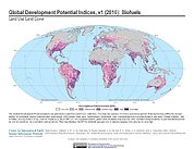
Global Development Potential Indices
National Aeronautics and Space Administration —
The Global Development Potential Indices (DPIs) data set contains thirteen sector-level DPIs for sectors related to renewable energy (concentrated solar power,... -
Federal
Poverty Mapping Project: Small Area Estimates of Poverty and Inequality
National Aeronautics and Space Administration —
The Poverty Mapping Project: Small Area Estimates of Poverty and Inequality data set consists of consumption-based poverty, inequality and related measures for... -
Federal
Gridded Population of the World, Version 3 (GPWv3): Population Count Grid
National Aeronautics and Space Administration —
The Gridded Population of the World, Version 3 (GPWv3): Population Count Grid consists of estimates of human population for the years 1990, 1995, and 2000 by 2.5 arc-... -
Federal
Groundswell Spatial Population and Migration Projections at One-Eighth Degree According to SSPs and RCPs, 2010-2050
National Aeronautics and Space Administration —
The Groundswell Spatial Population and Migration Projections at One-Eighth Degree According to SSPs and RCPs, 2010-2050, data set provides a baseline population... -
Federal
U.S. Census Grids (Summary File 1), 2010
National Aeronautics and Space Administration —
The U.S. Census Grids (Summary File 1), 2010 data set contains grids of demographic and socioeconomic data from the year 2010 in ASCII and GeoTIFF formats. The grids... -
Federal
Global Rural-Urban Mapping Project, Version 1 (GRUMPv1): National Identifier Grid
National Aeronautics and Space Administration —
The Global Rural-Urban Mapping Project, Version 1 (GRUMPv1): National Identifier Grid is derived from the land area grid to create a raster surface where pixels... -
Federal
Gridded Population of the World, Version 3 (GPWv3): Population Count Grid, Future Estimates
National Aeronautics and Space Administration —
The Gridded Population of the World, Version 3 (GPWv3): Population Count Grid, Future Estimates consists of estimates of human population for the years 2005, 2010,... -
Federal
Global Cyclone Mortality Risks and Distribution
National Aeronautics and Space Administration —
The Global Cyclone Mortality Risks and Distribution is a 2.5 minute grid of global cyclone mortality risks. Gridded Population of the World, Version 3 (GPWv3) data... -
Federal
Global Rural-Urban Mapping Project, Version 1 (GRUMPv1): Coastlines
National Aeronautics and Space Administration —
The Global Rural-Urban Mapping Project, Version 1 (GRUMPv1): Coastlines data are derived from the land area grids to show the outlines of pixels (cells) that contain... -
Federal
Groundswell Africa Spatial Population and Migration Projections at One-Eighth Degree According to SSPs and RCPs, 2010-2050
National Aeronautics and Space Administration —
The Groundswell Africa Spatial Population and Migration Projections at One-Eighth Degree According to SSPs and RCPs, 2010-2050 data set provides a baseline population... -
Federal
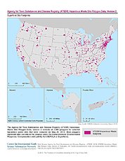
ATSDR Hazardous Waste Site Polygon Data, Version 2
National Aeronautics and Space Administration —
The Agency for Toxic Substances and Disease Registry (ATSDR) Hazardous Waste Site Polygon Data, Version 2 consists of 2,080 polygons for selected hazardous waste... -
Federal
Global Rural-Urban Mapping Project, Version 1 (GRUMPv1): Urban Extents Grid
National Aeronautics and Space Administration —
The Global Rural-Urban Mapping Project, Version 1 (GRUMPv1): Urban Extents Grid distinguishes urban and rural areas based on a combination of population counts...

Official websites use .gov
A
.gov website belongs to an official government
organization in the United States.
Secure .gov websites use HTTPS
A
lock (
) or https:// means you’ve safely connected to
the .gov website. Share sensitive information only on official,
secure websites.