
-
Federal
Gridded Population of the World, Version 4 (GPWv4): Population Count, Revision 11
National Aeronautics and Space Administration —
The Gridded Population of the World, Version 4 (GPWv4): Population Count, Revision 11 consists of estimates of human population (number of persons per pixel),... -
Federal
Global Flood Hazard Frequency and Distribution
National Aeronautics and Space Administration —
The Global Flood Hazard Frequency and Distribution is a 2.5 minute grid derived from a global listing of extreme flood events between 1985 and 2003 (poor or missing... -
Federal
Global Landslide Hazard Distribution
National Aeronautics and Space Administration —
The Global Landslide Hazard Distribution is a 2.5 minute grid of global landslide and snow avalanche hazards based upon work of the Norwegian Geotechnical Institute... -
Federal
Global Human Settlement Layer: Population and Built-Up Estimates, and Degree of Urbanization Settlement Model Grid
National Aeronautics and Space Administration —
The Global Human Settlement Layer: Population and Built-Up Estimates, and Degree of Urbanization Settlement Model Grid data set provides gridded data on human... -
Federal
Global Earthquake Hazard Distribution - Peak Ground Acceleration
National Aeronautics and Space Administration —
The Global Earthquake Hazard Distribution - Peak Ground Acceleration is a 2.5 minute grid of global earthquake hazards developed using Global Seismic Hazard Program... -
Federal
Global Cyclone Proportional Economic Loss Risk Deciles
National Aeronautics and Space Administration —
The Global Cyclone Proportional Economic Loss Risk Deciles is a 2.5 minute grid of cyclone hazard economic loss as proportions of Gross Domestic Product (GDP) per... -
Federal
Global Estimated Net Migration Grids by Decade: 1970-2000
National Aeronautics and Space Administration —
The Global Estimated Net Migration by Decade: 1970-2000 data set provides estimates of net migration over the three decades from 1970 to 2000. Because of the lack of... -
Federal
Global Fertilizer and Manure, Version 1: Phosphorus in Manure Production
National Aeronautics and Space Administration —
The Phosphorus in Manure Production data set of the Global Fertilizer and Manure, Version 1 Data Collection represents the amount of phosphorous in manure produced... -
Federal
Poverty Mapping Project: Global Subnational Prevalence of Child Malnutrition
National Aeronautics and Space Administration —
The Poverty Mapping Project: Global Subnational Prevalence of Child Malnutrition data set consists of estimates of the percentage of children with weight-for-age... -
Federal
ARECIBO MOON RADIO TELESCOPE CALIBRATED 70 CM RADAR V1.0
National Aeronautics and Space Administration —
Backscatter image data of the Moon made with Arecibo 70 cm radar in 1986 and 1987. The observations were made to demonstrate mapping resolution of 0.5 - 1.0... -
Federal
Wind SMS Key Parameter 4-hour Data
National Aeronautics and Space Administration —
Combined SWICS and STICS data containing 4 hour averaged alpha particle velocity, C/O abundance ratio, and carbon and oxygen ionization temperatures. Time is for the... -
Federal
Anthropogenic Biomes of the World, Version 2: 1700
National Aeronautics and Space Administration —
The Anthropogenic Biomes of the World, Version 2: 1700 data set describes anthropogenic transformations within the terrestrial biosphere caused by sustained direct... -
Federal
VIIRS (NOAA 21) I Band 375 m Active Fire Product NRT (Vector data)
National Aeronautics and Space Administration —
Near real-time (NRT) NOAA-21 Visible Infrared Imaging Radiometer Suite (VIIRS) Active Fire detection product is based on that instrument's 375 m nominal resolution... -
Federal
Spatial Data Access Tool (SDAT)
National Aeronautics and Space Administration —
The ORNL DAAC Spatial Data Access Tool (SDAT) is a suite of Web-based applications that enable users to visualize and download spatial data in user-selected... -
Federal
Global Drought Total Economic Loss Risk Deciles
National Aeronautics and Space Administration —
The Global Drought Total Economic Loss Risk Deciles is a 2.5 minute grid of global drought total economic loss risks. A process of spatially allocating Gross Domestic... -
Federal
Global Rural-Urban Mapping Project, Version 1 (GRUMPv1): Settlement Points
National Aeronautics and Space Administration —
The Global Rural-Urban Mapping Project, Version 1 (GRUMPv1): Settlement Points contains geospatial location for selected settlements. This data set is produced by the... -
Federal
Global Human Modification of Terrestrial Systems
National Aeronautics and Space Administration —
The Global Human Modification of Terrestrial Systems data set provides a cumulative measure of the human modification of terrestrial lands across the globe at a 1-km... -
Federal
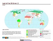
Last of the Wild Project, Version 2, 2005 (LWP-2): Last of the Wild Dataset (Geographic)
National Aeronautics and Space Administration —
The Last of the Wild Dataset of the Last of the Wild Project, Version 2, 2005 (LWP-2) is derived from the LWP-2 Human Footprint Dataset. The gridded data are...

Official websites use .gov
A
.gov website belongs to an official government
organization in the United States.
Secure .gov websites use HTTPS
A
lock (
) or https:// means you’ve safely connected to
the .gov website. Share sensitive information only on official,
secure websites.