
-
Federal
ASTER Global Digital Elevation Model V003
National Aeronautics and Space Administration —
The Terra Advanced Spaceborne Thermal Emission and Reflection Radiometer (ASTER) Global Digital Elevation Model (GDEM) Version 3 (ASTGTM) provides a global digital... -
Federal
SDG Indicator 9.1.1: Rural Access Index (RAI), 2023 Release
National Aeronautics and Space Administration —
The SDG Indicator 9.1.1: The Rural Access Index (RAI), 2023 Release data set, part of the SDGI collection, measures the proportion of the rural population who live... -
Federal
Washington Double Star Catalog
National Aeronautics and Space Administration —
The Washington Double Star Catalog (WDS), maintained by the United States Naval Observatory (USNO), is the world's principal database of astrometric double and... -
Federal
Global Gridded Soil Phosphorus Distribution Maps at 0.5-degree Resolution
National Aeronautics and Space Administration —
This data set provides estimates of different forms of naturally occurring soil phosphorus (P) including labile inorganic P, organic P, occluded P, secondary mineral... -
Federal
Dar es Salaam Land Use and Informal Settlement Data Set
National Aeronautics and Space Administration —
The Dar es Salaam Land Use and Informal Settlement Data Set represents urban land use and consolidation of informal settlements for the years 1982, 1992, 1998, and... -
Federal
China Dimensions Data Collection: China County-Level Data on Population (Census) and Agriculture, Keyed to 1:1M GIS Map
National Aeronautics and Space Administration —
The China County-Level Data on Population (Census) and Agriculture, Keyed To 1:1M GIS Map consists of census, agricultural economic, and boundary data for the... -
Federal
China Dimensions Data Collection: China County-Level Data from Provincial Economic Yearbooks, Keyed to 1:1M GIS Map
National Aeronautics and Space Administration —
The China County-Level Data on Provincial Economic Yearbooks, Keyed To 1:1M GIS Map consists of socioeconomic and boundary data for the administrative regions of... -
Federal
NARSTO EPA_SS_HOUSTON TEXAQS2000 Particulate Matter FTIR Composition
National Aeronautics and Space Administration —
The NARSTO_EPA_SS_HOUSTON_TEXAQS2000_PM_FTIR measurement data consist of absolute absorbance areas for organonitrates, sulfate, aliphatic carbon and carbonyl... -
Federal
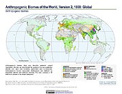
Anthropogenic Biomes of the World, Version 2: 1800
National Aeronautics and Space Administration —
The Anthropogenic Biomes of the World, Version 2: 1800 data set describes anthropogenic transformations within the terrestrial biosphere caused by sustained direct... -
Federal
GPM GROUND VALIDATION DUAL-FREQUENCY DUAL-POLARIZED DOPPLER RADAR (D3R) GCPEX V1
National Aeronautics and Space Administration —
The GPM Ground Validation Dual-frequency Dual-polarized Doppler Radar (D3R) GCPEx and IFloodS data sets contain radar reflectivity and doppler velocity measurements.... -
Federal
NARSTO EPA Supersite (SS) Fresno, Beta Attenuation Monitors (BAM) Meteorological Data
National Aeronautics and Space Administration —
NARSTO_EPA_SS_FRESNO_MET_DATA is North American Research Strategy for Tropospheric Ozone (NARSTO) Environmental Protection Agency (EPA) Supersite (SS) Fresno, Beta... -
Federal
Rodent Research-3-CASIS: Mouse adrenal gland transcriptomic proteomic and epigenomic data
National Aeronautics and Space Administration —
The Rodent Research-3 (RR-3) mission was sponsored by the pharmaceutical company Eli Lilly and Co. and the Center for the Advancement of Science in Space to study the... -
Federal
Spatially resolved transcriptional analysis of hearts from mice flown on the RR-3 mission
National Aeronautics and Space Administration —
The Rodent Research-3 (RR-3) mission was sponsored by the pharmaceutical company Eli Lilly and Co. and the Center for the Advancement of Science in Space to study the... -
Federal
SAFARI 2000 MISR Level 2 Data, Southern Africa, Dry Season 2000
National Aeronautics and Space Administration —
MISR (Multi-angle Imaging SpectroRadiometer) views the sunlit Earth simultaneously at nine widely spaced and collects global images with high spatial detail in four... -
Federal
Measurement of Air Pollution from Satellites (MAPS) Space Radar Laboratory - 1 (SRL1) Carbon Monoxide Second by Second data
National Aeronautics and Space Administration —
MAPS Overview The MAPS experiment measures the global distribution of carbon monoxide (CO) mixing ratios in the free troposphere. Because of MAPS' previous flights on... -
Federal
GPM Ground Validation Dual-frequency Dual-polarized Doppler Radar (D3R) ICE POP
National Aeronautics and Space Administration —
The GPM Ground Validation Dual-frequency Dual-polarized Doppler Radar (D3R) ICE POP dataset includes reflectivity, differential reflectivity, copolar correlation... -
Federal
Longwave-infrared spectral imagery in support of COMEX, 2014
National Aeronautics and Space Administration —
This dataset provides calibrated at-sensor radiance, retrieved surface brightness temperature, and adaptive coherence estimator (ACE) detection imagery of methane,... -
Federal
Ice Draft and Ice Velocity Data in the Beaufort Sea, 1990-2003, Version 1
National Aeronautics and Space Administration —
This data set provides measurement of sea ice draft (m) and the movement of sea ice (cm/s) over the continental shelf of the Eastern Beaufort Sea. The data set spans... -
Federal
NARSTO EPA Supersite (SS) Atlanta 1999 Air Chemistry, Particulate Matter (PM), and Meteorological Data
National Aeronautics and Space Administration —
The NARSTO_EPA_SS_ATLANTA_1999_CHEM_PM_MET_DATA is the North American Research Strategy for Tropospheric Ozone (NARSTO) Environmental Protection Agency (EPA)... -
Federal
NARSTO EPA Supersite (SS) Atlanta 1999 University of Alabama-Huntsville (UAH) Mobile Integrated Profiling System (MIPS) Wind Data
National Aeronautics and Space Administration —
NARSTO_EPA_SS_ATLANTA_1999_UAH_MIPS_DATA is the North American Research Strategy for Tropospheric Ozone (NARSTO) Environmental Protection Agency (EPA) Supersite (SS)...

Official websites use .gov
A
.gov website belongs to an official government
organization in the United States.
Secure .gov websites use HTTPS
A
lock (
) or https:// means you’ve safely connected to
the .gov website. Share sensitive information only on official,
secure websites.