
-
Federal
NASA Earth Observatory Images
National Aeronautics and Space Administration —
The Earth Observatory is part of the EOS Project Science Office located at NASA Goddard Space Flight Center. -
Federal
Temperature Stratification in a Cryogenic Fuel Tank
National Aeronautics and Space Administration —
A reduced dynamical model describing temperature stratification effects driven by natural convection in a liquid hydrogen cryogenic fuel tank has been developed. It... -
Federal
China Dimensions Data Collection: China County-Level Data from Provincial Economic Yearbooks, Keyed to 1:1M GIS Map
National Aeronautics and Space Administration —
The China County-Level Data on Provincial Economic Yearbooks, Keyed To 1:1M GIS Map consists of socioeconomic and boundary data for the administrative regions of... -
Federal
Methane Plumes Derived from AVIRIS-NG over Point Sources across California, 2016-2017
National Aeronautics and Space Administration —
This dataset provides maps of methane (CH4) plumes along flight lines over identified methane point-source emitting infrastructure across the State of California, USA... -
Federal
Central American Vegetation/Land Cover Classification and Conservation Status
National Aeronautics and Space Administration —
The Central American Vegetation/Land Cover Classification and Conservation Status consists of GIS coverages of vegetation classes (forests, woodlands, savannas,... -
Federal
NASA 3D Models: GRACE
National Aeronautics and Space Administration —
GRACE (Gravity Recovery and Climate Experiment), twin satellites launched in March 2002, are making detailed measurements of Earth's gravity field which will lead to... -
Federal
NASA Landsat Data Collection
National Aeronautics and Space Administration —
The NASA Landsat Data Collection (NLDC) is a compilation of Landsat multispectral scanner (MSS) scenes and Landsat thematic mapper (TM) scenes. This compilation of... -
Federal
2008 Environmental Performance Index (EPI)
National Aeronautics and Space Administration —
The 2008 Environmental Performance Index (EPI) centers on two broad environmental protection objectives: (1) reducing environmental stresses on human health, and (2)... -
Federal
USGS Antarctic Single Frame Records
National Aeronautics and Space Administration —
Antarctic Single Frame Records are a collection of aerial photographs over Antarctica from the United States Antarctic Resource Center (USARC) and the British... -
Federal
Designing Data-Driven Battery Prognostic Approaches for Variable Loading Profiles: Some Lessons Learned
National Aeronautics and Space Administration —
Among various approaches for implementing prognostic algorithms data-driven algorithms are popular in the industry due to their intuitive nature and relatively fast... -
Federal
IceBridge Photon Counting Lidar L1B Subset Geolocated Photon Elevations V001
National Aeronautics and Space Administration —
This data set contains nadir photon counting data captured over Antarctica using the Sigma Space photon counting lidar. Position and orientation data are included.... -
Federal
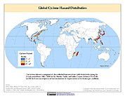
Global Cyclone Hazard Frequency and Distribution
National Aeronautics and Space Administration —
The Global Cyclone Hazard Frequency and Distribution is a 2.5 minute grid based on more than 1,600 storm tracks for the period 1 January 1980 through 31 December 2000... -
Federal
ARC Code TI: Crisis Mapping Toolkit
National Aeronautics and Space Administration —
The Crisis Mapping Toolkit (CMT) is a collection of tools for processing geospatial data (images, satellite data, etc.) into cartographic products that improve... -
Federal
Classification of Damage Signatures in Composite Plates using On
National Aeronautics and Space Administration —
Damage characterization through wave propagation and scattering is of considerable interest to many non-destructive evaluation techniques. For fiber-reinforced... -
Federal
Near-Earth Object Human Space Flight Accessible Targets Study (NHATS)
National Aeronautics and Space Administration —
This list of potential mission targets should not be interpreted as a complete list of viable NEAs for an actual human exploration mission. As the NEA orbits are... -
Federal
Natural Resource Management Index (NRMI), 2011 Release
National Aeronautics and Space Administration —
The Natural Resource Management Index (NRMI), 2011 Release is a composite index for 174 countries derived from the average of four proximity-to-target indicators for... -
Federal
SCOAPE R/V Point Sur Data
National Aeronautics and Space Administration —
SCOAPE_RVPointSur_Data is the data collected from instruments onboard the University of Southern Mississippi’s Research Vessel (R/V) Point Sur during the Satellite... -
Federal
A Combined Model-Based and Data-Driven Prognostic Approach for Aircraft System Life Management
National Aeronautics and Space Administration —
Failure prognosis - as a natural extension to the fault detection and isolation (FDI) problem - has become a key issue in a world where the economic impact of system... -
Federal
A DISTRIBUTED PROGNOSTIC HEALTH MANAGEMENT ARCHITECTURE
National Aeronautics and Space Administration —
This paper introduces a generic distributed prognostic health management (PHM) architecture with specific application to the electrical power systems domain. Current... -
Federal
Water Quality (WQ) monitoring program for Clear Lake, CA
National Aeronautics and Space Administration —
Clear Lake is a large, shallow, hypereutrophic lake in Northern California, USA. Clear Lake is an important water resource for the surrounding community offering many...

Official websites use .gov
A
.gov website belongs to an official government
organization in the United States.
Secure .gov websites use HTTPS
A
lock (
) or https:// means you’ve safely connected to
the .gov website. Share sensitive information only on official,
secure websites.