
-
Federal
U.S. Climate Risk Projections by County, 2040-2049
National Aeronautics and Space Administration —
The U.S. Climate Risk Projections by County, 2040-2049 data set contains a projection for 2040-2049 risk for the entire contiguous U.S. at the county level with a... -
Federal
Geocoded Disasters (GDIS) Dataset
National Aeronautics and Space Administration —
The Geocoded Disasters (GDIS) Dataset is a geocoded extension of a selection of natural disasters from the Centre for Research on the Epidemiology of Disasters'... -
Federal
UAVSAR_POLSAR_METADATA
National Aeronautics and Space Administration —
UAVSAR PolSAR Scene Metadata -
Federal
UAVSAR_POLSAR_SLOPE
National Aeronautics and Space Administration —
UAVSAR PolSAR Scene Slope -
Federal
ECOSTRESS Evaporative Stress Index PT-JPL Daily L4 Global 70m V001
National Aeronautics and Space Administration —
The ECOsystem Spaceborne Thermal Radiometer Experiment on Space Station (ECOSTRESS) mission measures the temperature of plants to better understand how much water... -
Federal
ABoVE: Ignitions, Burned Area, and Emissions of Fires in AK, YT, and NWT, 2001-2018
National Aeronautics and Space Administration —
This dataset provides estimates of daily burned area, carbon emissions, and uncertainty, and daily fire ignition locations for boreal fires in Alaska, U.S., and in... -
Federal
UAVSAR_POLSAR_ML_COMPLEX_GRD_3X3
National Aeronautics and Space Administration —
UAVSAR PolSAR Scene Projected Multilook 3x3 -
Federal
Global Drought Total Economic Loss Risk Deciles
National Aeronautics and Space Administration —
The Global Drought Total Economic Loss Risk Deciles is a 2.5 minute grid of global drought total economic loss risks. A process of spatially allocating Gross Domestic... -
Federal
Global Multihazard Mortality Risks and Distribution
National Aeronautics and Space Administration —
The Global Multihazard Mortality Risks and Distribution is a 2.5 minute grid identifying and characterizing the nature of multihazard risk at the global scale. For... -
Federal
CMS: Forest Carbon Stocks, Emissions, and Net Flux for the Conterminous US: 2005-2010
National Aeronautics and Space Administration —
This data set provides maps of estimated carbon in forests of the 48 continental states of the US for the years 2005-2010. Carbon (termed committed carbon) stocks... -
Federal
Global Drought Proportional Economic Loss Risk Deciles
National Aeronautics and Space Administration —
The Global Drought Proportional Economic Loss Risk Deciles is a 2.5 minute grid of drought hazard economic loss as proportions of Gross Domestic Product (GDP) per... -
Federal
LBA-ECO ND-02 Soil Gas Flux, Rainfall Exclusion, km 67, Tapajos National Forest
National Aeronautics and Space Administration —
Moist tropical forests in Amazonia and elsewhere are subjected to increasingly severe drought episodes through the El Nino-Southern Oscillation (ENSO) and possibly... -
Federal
NPP Tropical Forest: Cinnamon Bay, U.S. Virgin Islands, 1982-1993, R1
National Aeronautics and Space Administration —
This data set contains three ASCII files (.txt format). One data file contains above-ground biomass, litter, litterfall, herbivory, biomass change, and above-ground... -
Federal
LBA-ECO CD-05 Understory Fuel Stick Moisture, km 67 Site, Para, Brazil: 1998-2000
National Aeronautics and Space Administration —
This data set contains moisture content measurements for fuel sticks located in the forest understory of the rainfall exclusion experimental site, Tapajos National... -
Federal
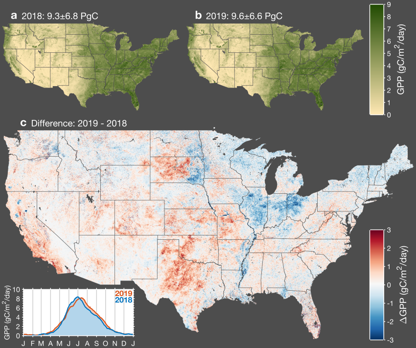
CMS: Daily Gross Primary Productivity over CONUS from TROPOMI SIF, 2018-2021
National Aeronautics and Space Administration —
This dataset includes estimates of gross primary production (GPP) for the conterminous U.S., for 2018-02-15 to 2021-10-15, based on measurements of solar-induced... -
Federal
Global Multihazard Total Economic Loss Risk Deciles
National Aeronautics and Space Administration —
The Global Multihazard Total Economic Loss Risk Deciles is a 2.5 minute grid of global multihazard total economic loss risks. First, for each of the considered... -
Federal
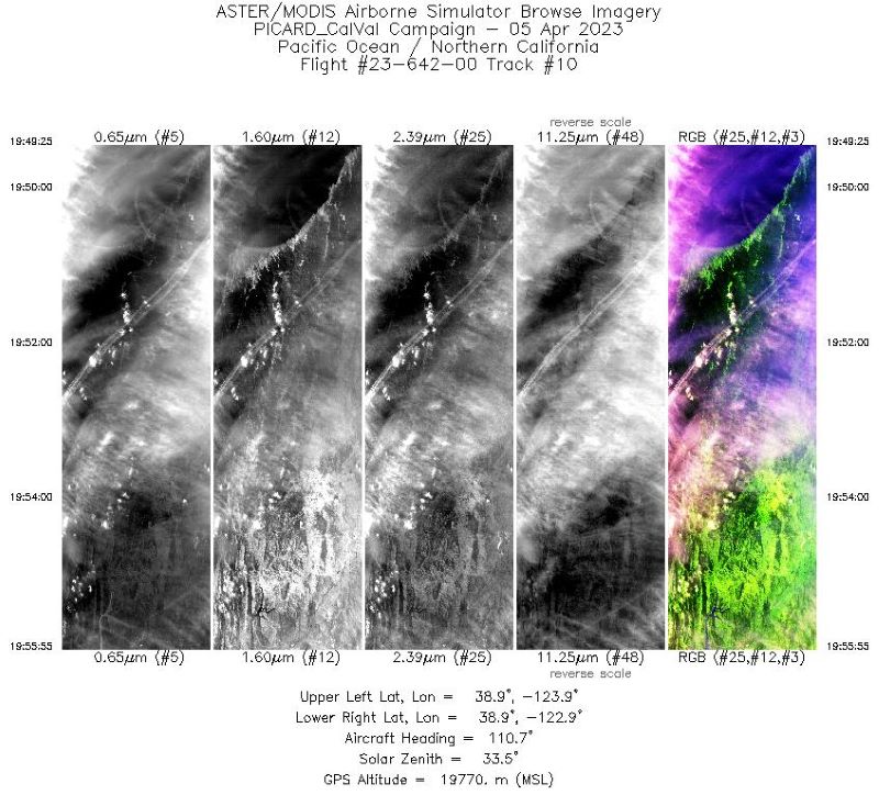
MASTER: Western Diversity Time Series Campaign, WDTS, Spring 2023
National Aeronautics and Space Administration —
This dataset includes Level 1B (L1B) and Level 2 (L2) data products from the MODIS/ASTER Airborne Simulator (MASTER) instrument. The spectral data were collected as... -
Federal
UAVSAR_POLSAR_ML_COMPLEX_GRD
National Aeronautics and Space Administration —
UAVSAR PolSAR Scene Projected -
Federal
Vegetation Drought Response Index (VegDRI)
National Aeronautics and Space Administration —
The National Drought Mitigation Center produces VegDRI in collaboration with the US Geological Survey's (USGS) Center for Earth Resources Observation and Science...

Official websites use .gov
A
.gov website belongs to an official government
organization in the United States.
Secure .gov websites use HTTPS
A
lock (
) or https:// means you’ve safely connected to
the .gov website. Share sensitive information only on official,
secure websites.