
-
Federal
India Village-Level Geospatial Socio-Economic Data Set: 1991, 2001
National Aeronautics and Space Administration —
The India Village-Level Geospatial Socio-Economic Data Set: 1991, 2001 is a compilation of the finest level of administrative boundaries in India (village/town-level)... -
Federal
Gridded Population of the World, Version 4 (GPWv4): Population Density, Revision 11
National Aeronautics and Space Administration —
The Gridded Population of the World, Version 4 (GPWv4): Population Density, Revision 11 consists of estimates of human population density (number of persons per... -
Federal
China Dimensions Data Collection: GuoBiao (GB) Codes for the Administrative Divisions of the Peoples Republic of China
National Aeronautics and Space Administration —
The GuoBiao (GB) Codes for the Administrative Divisions of the People's Republic of China consists of geographic codes for the administrative divisions of China. The... -
Federal
China Dimensions Data Collection: China County-Level Data from Provincial Economic Yearbooks, Keyed to 1:1M GIS Map
National Aeronautics and Space Administration —
The China County-Level Data on Provincial Economic Yearbooks, Keyed To 1:1M GIS Map consists of socioeconomic and boundary data for the administrative regions of... -
Federal
Global Reservoir and Dam Database, Version 1 (GRanDv1): Dams, Revision 01
National Aeronautics and Space Administration —
The Global Reservoir and Dam Database, Version 1, Revision 01 (v1.01) contains 6,862 records of reservoirs and their associated dams with a cumulative storage... -
Federal
Global Fertilizer and Manure, Version 1: Nitrogen in Manure Production
National Aeronautics and Space Administration —
The Nitrogen in Manure Production data set of the Global Fertilizer and Manure, Version 1 Data Collection represents the amount of nitrogen manure produced and... -
Federal
Last of the Wild Project, Version 2, 2005 (LWP-2): Global Human Influence Index (HII) Dataset (Geographic)
National Aeronautics and Space Administration —
The Global Human Influence Index Dataset of the Last of the Wild Project, Version 2, 2005 (LWP-2) is a global dataset of 1-kilometer grid cells, created from nine... -
Federal
Georeferenced Population Datasets of Mexico (GEO-MEX): Population Database of Mexico
National Aeronautics and Space Administration —
The Population Database of Mexico contains geographically referenced population data for Mexican states, municipalities and localities from the 1990 Mexican... -
Federal
SWOT Sword of Science River Discharge Products Version 1
National Aeronautics and Space Administration —
The SWOT Sword of Science River Discharge Products dataset from the Surface Water and Ocean Topography (SWOT) mission and produced by the Discharge Algorithm Working... -
Federal
Global Annual PM2.5 Grids from MODIS, MISR and SeaWiFS Aerosol Optical Depth (AOD), 1998-2019, V4.GL.03 NGDA
National Aeronautics and Space Administration —
The Global Annual PM2.5 Grids from MODIS, MISR and SeaWiFS Aerosol Optical Depth (AOD), 1998-2019, V4.GL.03 consists of annual concentrations (micrograms per cubic... -
Federal
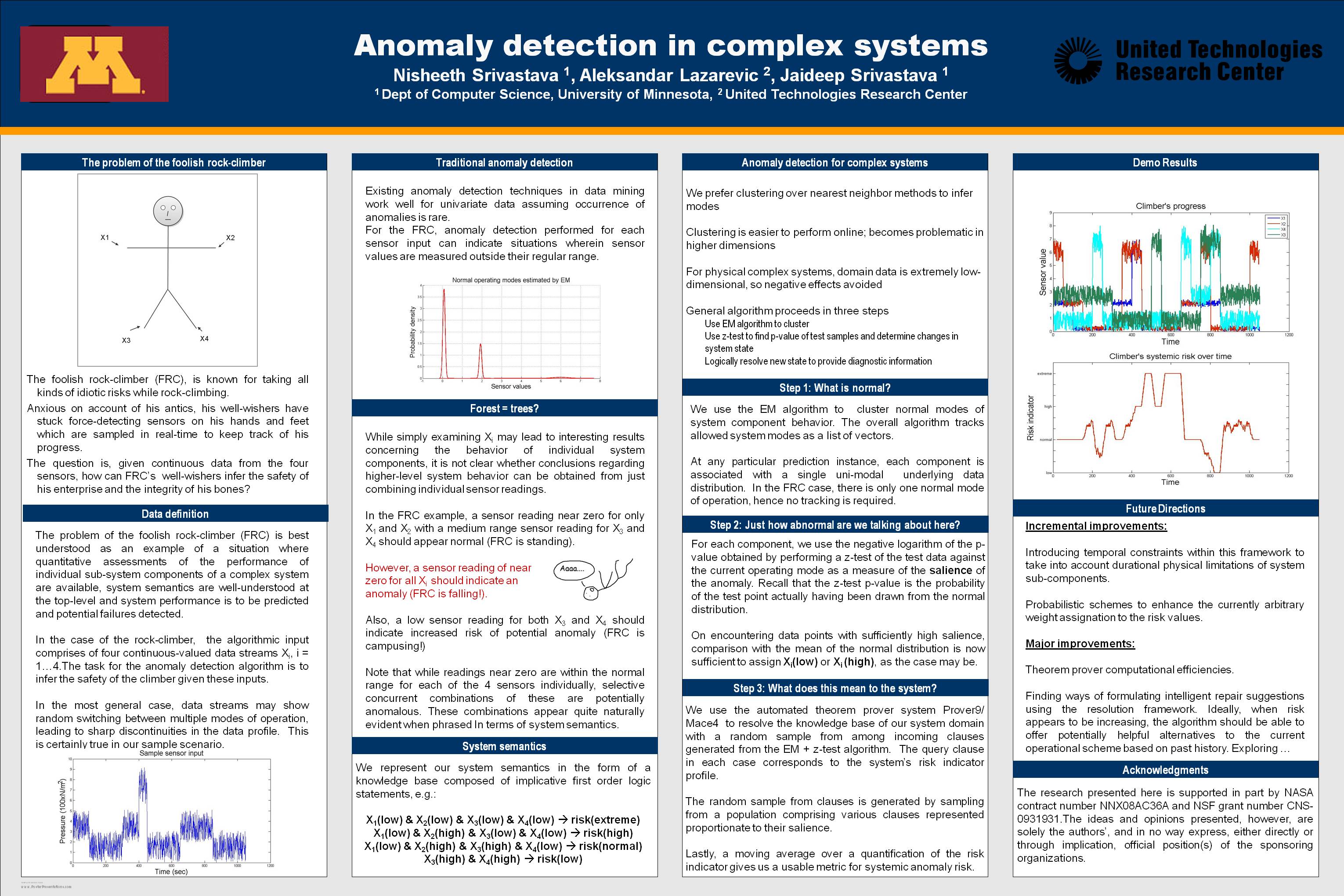
Anomaly Detection for Complex Systems
National Aeronautics and Space Administration —
In performance maintenance in large, complex systems, sensor information from sub-components tends to be readily available, and can be used to make predictions about... -
Federal
Altimeter Corrected Elevations, Version 2 (ACE2)
National Aeronautics and Space Administration —
The Altimeter Corrected Elevations, Version 2 (ACE2) data set, is the Global Digital Elevation Model (GDEM) created by using multi-mission Satellite Radar Altimetry... -
Federal
CAR INTEX-B Long-range Pollution Transportation L1 V1 (CAR_INTEXB_L1C) at GES DISC
National Aeronautics and Space Administration —
INTEX-B (Intercontinental Chemical Transport Experiment-Phase B) focuses on the long-range transport of pollution, global atmospheric photochemistry, and the effects... -
Federal
China Dimensions Data Collection: Bibliography of Chinese Administrative Geography
National Aeronautics and Space Administration —
The Bibliography of Chinese Administrative Geography is a historical collection of bibliographic information on 75 published books describing the administrative... -
Federal
SWOT Level 2 River Single-Pass Vector Reach Data Product, Version 2.0
National Aeronautics and Space Administration —
The SWOT Level 2 River Single-Pass Vector Reach Data Product from the Surface Water Ocean Topography (SWOT) mission provides water surface elevation, slope, width,... -
Federal
Delta-X: AVIRIS-NG L3 Derived Herbaceous Aboveground Biomass, MRD, Louisiana, USA, V3
National Aeronautics and Space Administration —
This dataset includes high-resolution (~5 m) gridded estimates of aboveground biomass (AGB), aboveground necromass (AGN), and aboveground net primary productivity... -
Federal
Delta-X: Delft3D Sediment Model, Site 322, Terrebonne Basin, MRD, Louisiana, USA
National Aeronautics and Space Administration —
This dataset contains the Delft3D model of the intensive site 322 in the Terrebonne Basin along the Mississippi River Delta (MRD) in coastal Louisiana. Simulations... -
Federal
Monthly Frequency of Dust Storm over Land for Varying Intensities, Based on MODIS Aqua Deep Blue Level 2 Aerosol Products MYD04_L2 Collection 6.1, on a Global 0.1 by 0.1 Degree Grid, Level 3 Version 1 (MYDFDS_MON_GLB_L3) at GES DISC
National Aeronautics and Space Administration —
Version 1 is the current version of the dataset.This collection MYDFDS_MON_GLB_L3 provides level 3 monthly frequency of dust storms (FDS) over land from 175°W to...

Official websites use .gov
A
.gov website belongs to an official government
organization in the United States.
Secure .gov websites use HTTPS
A
lock (
) or https:// means you’ve safely connected to
the .gov website. Share sensitive information only on official,
secure websites.