
-
Federal
USGS High Resolution Orthoimagery recent views
National Aeronautics and Space Administration —
High resolution orthorectified images combine the image characteristics of an aerial photograph with the geometric qualities of a map. An orthoimage is a uniform-... -
Federal
Meteorite Landings API recent views
National Aeronautics and Space Administration —
API using comprehensive data set from The Meteoritical Society that contains information on all of the known meteorite landings. -
Federal
Binary Neutron Star Merger recent views
National Aeronautics and Space Administration —
Numerically-generated gravitational waveforms for binary neutron stars. -
Federal
FLDAS Noah Land Surface Model L4 Global Monthly 0.1 x 0.1 degree (MERRA-2 and CHIRPS) V001 (FLDAS_NOAH01_C_GL_M) at GES DISC recent views
National Aeronautics and Space Administration —
This dataset contains a series of land surface parameters simulated from the Noah 3.6.1 model in the Famine Early Warning Systems Network (FEWS NET) Land Data... -
Federal
OCO-2 GEOS Level 3 daily, 0.5x0.625 assimilated CO2 V10r (OCO2_GEOS_L3CO2_DAY) at GES DISC recent views
National Aeronautics and Space Administration —
This is the Gridded Daily OCO-2 Carbon Dioxide assimilated dataset. The OCO-2 mission provides the highest quality space-based XCO2 retrievals to date. However, the... -
Federal
SatCORPS CERES GEO Edition 4 GOES-16 Northern Hemisphere Version 1.2 recent views
National Aeronautics and Space Administration —
CER_GEO_Ed4_GOE16_NH_V01.2 is the Satellite ClOud and Radiation Property retrieval System (SatCORPS) Clouds and the Earth's Radiant Energy System (CERES)... -
Federal
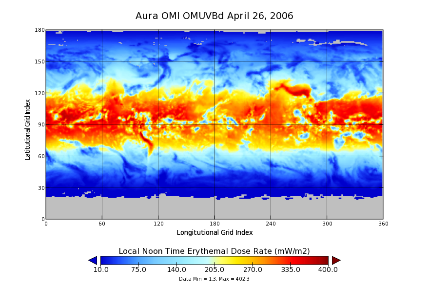
OMI/Aura Surface UVB Irradiance and Erythemal Dose Daily L3 Global Gridded 1.0 degree x 1.0 degree V3 (OMUVBd) at GES DISC recent views
National Aeronautics and Space Administration —
This is Level-3 daily global gridded Aura-OMI Spectral Surface UVB Irradiance and Erythemal Dose product (OMUVBd). The OMUVBd product contains global erythemally... -
Federal
OMNIWeb at the Space Physics Data Facility (SPDF) recent views
National Aeronautics and Space Administration —
Hourly-averaged near-Earth solar wind magnetic field and plasma, etc. The web services consists of OMNI data (spacecraft-interspersed, near-Earth solar wind data);... -
Federal
Sea Ice Index, Version 3 recent views
National Aeronautics and Space Administration —
The Sea Ice Index provides a quick look at Arctic- and Antarctic-wide changes in sea ice. It is a source for consistent, up-to-date sea ice extent and concentration... -
Federal
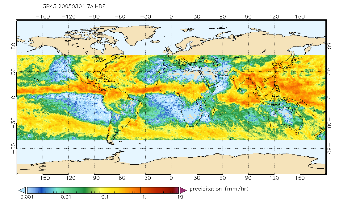
TRMM (TMPA/3B43) Rainfall Estimate L3 1 month 0.25 degree x 0.25 degree V7 (TRMM_3B43) at GES DISC recent views
National Aeronautics and Space Administration —
TMPA (3B43) dataset have been discontinued as of Dec. 31, 2019, and users are strongly encouraged to shift to the successor IMERG dataset (doi:... -
Federal
Ground-Based Global Navigation Satellite System (GNSS) GPS Broadcast Ephemeris Data (sub-hourly files) from NASA CDDIS recent views
National Aeronautics and Space Administration —
This dataset consists of ground-based Global Navigation Satellite System (GNSS) GPS Broadcast Ephemeris Data (sub-hourly files) from the NASA Crustal Dynamics Data... -
Federal
Global Land Cover Characterization Program recent views
National Aeronautics and Space Administration —
The Global Land Cover Characterization Project was established to meet science data requirements identified by the International Geosphere and Biosphere Programme... -
Federal
NASA 3D Models: Saturn V recent views
National Aeronautics and Space Administration —
Polygons: 34814 Vertices: 19011 -
Federal
ECOSTRESS Land Surface Temperature and Emissivity Daily L2 Global 70m V001 recent views
National Aeronautics and Space Administration —
The ECOsystem Spaceborne Thermal Radiometer Experiment on Space Station (ECOSTRESS) mission measures the temperature of plants to better understand how much water... -
Federal
U.S. Geological Survey Aerial Photography recent views
National Aeronautics and Space Administration —
The U.S. Geological Survey (USGS) Aerial Photography data set includes over 2.5 million film transparencies. Beginning in 1937, photographs were acquired for mapping... -
Federal
Sentinel-5P TROPOMI Methane CH4 1-Orbit L2 7km x 7km V1 (S5P_L2__CH4___) at GES DISC recent views
National Aeronautics and Space Administration —
Starting from August 6th in 2019, Sentinel-5P TROPOMI along-track high spatial resolution (~5.5km at nadir) has been implemented. For data after August 6th of 2019,... -
Federal
Propulsion Health Monitoring of a Turbine Engine Disk using Spin Test Data recent views
National Aeronautics and Space Administration —
On line detection techniques to monitor the health of rotating engine components are becoming increasingly attractive options to aircraft engine companies in order to... -
Federal
Fleet Level Anomaly Detection of Aviation Safety Data recent views
National Aeronautics and Space Administration —
For the purposes of this paper, the National Airspace System (NAS) encompasses the operations of all aircraft which are subject to air traffic control procedures. The...

Official websites use .gov
A
.gov website belongs to an official government
organization in the United States.
Secure .gov websites use HTTPS
A
lock (
) or https:// means you’ve safely connected to
the .gov website. Share sensitive information only on official,
secure websites.