
-
Federal
Combined GPS Broadcast Ephemeris Data (30-second sampling, hourly files) from NASA CDDIS
National Aeronautics and Space Administration —
This dataset consists of ground-based Global Navigation Satellite System (GNSS) Combined Broadcast Ephemeris Data (hourly files of all distinct navigation messages... -
Federal
Rodent Research-1 (RR1) National Lab Validation Flight: Mouse liver transcriptomic proteomic and epigenomic data
National Aeronautics and Space Administration —
The Rodent Reasearch-1 National Lab (RR-1 CASIS) experiment was performed to study the effect of microgravity on muscle wasting. RNA DNA and protein were purified... -
Federal
USGS High Resolution Orthoimagery
National Aeronautics and Space Administration —
High resolution orthorectified images combine the image characteristics of an aerial photograph with the geometric qualities of a map. An orthoimage is a uniform-... -
Federal
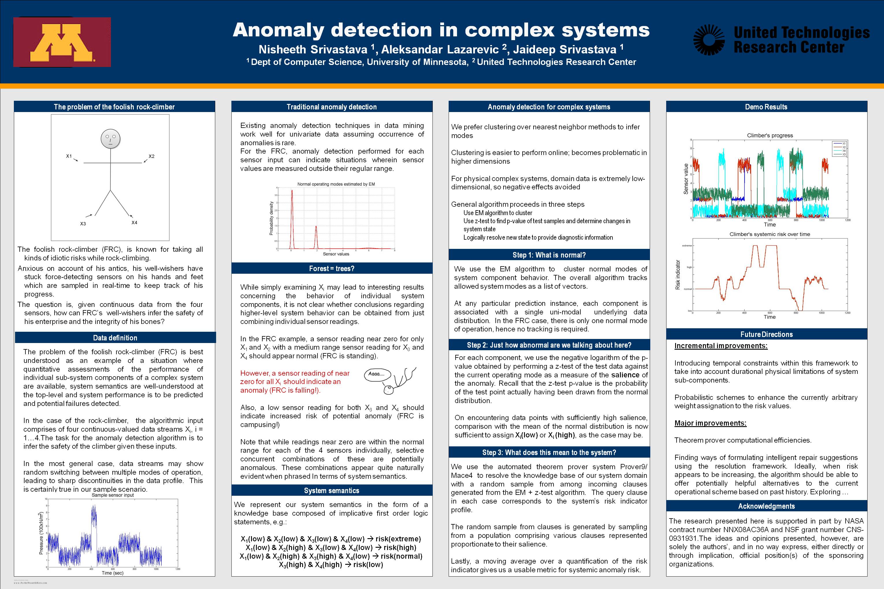
Anomaly Detection for Complex Systems
National Aeronautics and Space Administration —
In performance maintenance in large, complex systems, sensor information from sub-components tends to be readily available, and can be used to make predictions about... -
Federal
SWOT Sword of Science River Discharge Products Version 1
National Aeronautics and Space Administration —
The SWOT Sword of Science River Discharge Products dataset from the Surface Water and Ocean Topography (SWOT) mission and produced by the Discharge Algorithm Working... -
Federal
EPOXI EXOPLANET TRANSIT OBS - HRIV RAW IMAGES V1.0
National Aeronautics and Space Administration —
This data set set contains raw images of eight known transiting extrasolar planetary systems (hot Jupiters) acquired by the Deep Impact High Resolution Visible CCD... -
Federal
Gridded Population of the World, Version 4 (GPWv4): Population Density, Revision 11
National Aeronautics and Space Administration —
The Gridded Population of the World, Version 4 (GPWv4): Population Density, Revision 11 consists of estimates of human population density (number of persons per... -
Federal
SDG Indicator 9.1.1: Rural Access Index (RAI), 2023 Release
National Aeronautics and Space Administration —
The SDG Indicator 9.1.1: The Rural Access Index (RAI), 2023 Release data set, part of the SDGI collection, measures the proportion of the rural population who live... -
Federal
DEEP IMPACT SPICE KERNELS V1.0
National Aeronautics and Space Administration —
This data set includes the complete set of Deep Impact SPICE data files (``kernel files''), which can be accessed using SPICE software. The SPICE data contains... -
Federal
ASTEROID DYNAMICAL FAMILIES V4.1
National Aeronautics and Space Administration —
Dynamical family classification of asteroids by Zappala, et al., based on the hierarchical clustering method. -
Federal
MODIS/Aqua Near Real Time (NRT) 5-min Spacecraft attitude data from GBAD to be read via SDP Toolkit Binary Format
National Aeronautics and Space Administration —
PM1ATTNR is the Aqua Near Real Time (NRT) daily spacecraft attitude data file in native format. This is MODIS Ancillary Data. The data collection consists of PM1... -
Federal
SMAP L4 Global 3-hourly 9 km EASE-Grid Surface and Root Zone Soil Moisture Geophysical Data V007
National Aeronautics and Space Administration —
SMAP Level-4 (L4) surface and root zone soil moisture data are provided in three products: * SMAP L4 Global 3-hourly 9 km EASE-Grid Surface and Root Zone Soil... -
Federal
Suomi-NPP VIIRS Global Mapped Normalized Difference Vegetation Index Land Reflectance Data, version R2022.0
National Aeronautics and Space Administration —
The Visible and Infrared Imager/Radiometer Suite (VIIRS) is a multi-disciplinary instrument that is being flown on the Joint Polar Satellite System (JPSS) series of... -
Federal
Supporting Information for Global Navigation Satellite System (GNSS) Data and Products from NASA CDDIS
National Aeronautics and Space Administration —
This dataset consists of supporting information for use of ground-based Global Navigation Satellite System (GNSS) data and products from the NASA Crustal Dynamics... -
Federal
CEOS Cal Val Test Site - Libya 4 - Pseudo-Invariant Calibration Site (PICS) NGDA
National Aeronautics and Space Administration —
On the background of these requirements for sensor calibration, intercalibration and product validation, the subgroup on Calibration and Validation of the Committee... -
Federal
Global Reservoir and Dam Database, Version 1 (GRanDv1): Dams, Revision 01
National Aeronautics and Space Administration —
The Global Reservoir and Dam Database, Version 1, Revision 01 (v1.01) contains 6,862 records of reservoirs and their associated dams with a cumulative storage... -
Federal
SWOT Level 2 KaRIn Low Rate Sea Surface Height Data Product - Basic, Version 2.0
National Aeronautics and Space Administration —
The SWOT Level 2 KaRIn Low Rate Sea Surface Height Basic Data Product from the Surface Water Ocean Topography (SWOT) mission provides global sea surface height and... -
Federal
ASTEROID NAMES AND DISCOVERY V7.0
National Aeronautics and Space Administration —
This data set lists name, designation(s), and discovery circumstances for all asteroids numbered as of the given stop date. It is compiled and maintain by David... -
Federal
NACP North American Forest Dynamics Project: Forest Disturbance and Regrowth Data
National Aeronautics and Space Administration —
This data set provides the results of time-series analyses of Landsat imagery for 55 selected forested sites across the conterminous U.S.A. The output is a pair of...

Official websites use .gov
A
.gov website belongs to an official government
organization in the United States.
Secure .gov websites use HTTPS
A
lock (
) or https:// means you’ve safely connected to
the .gov website. Share sensitive information only on official,
secure websites.