
-
Federal
NACP MCI: Tower Atmospheric CO2 Concentrations, Upper Midwest Region, USA, 2007-2009
National Aeronautics and Space Administration —
This data set provides high precision and high accuracy atmospheric CO2 data from seven instrumented communication towers located in the U.S. Upper Midwest. The... -
Federal
Geobotanical and Impact Map Collection for Prudhoe Bay Oilfield, Alaska, 1972-2010
National Aeronautics and Space Administration —
This data set provides a collection of maps of geoecological characteristics of areas within the Beechey Point quadrangle near Prudhoe Bay on the North slope of... -
Federal
CERES ERBE-like Instantaneous TOA Estimates NOAA-20 FM6 Edition1
National Aeronautics and Space Administration —
CER_ES8_NOAA20-FM6_Edition1 data are ERBE-like instantaneous TOA estimates. Edition1 data are for instrument validation and are not suited for science publications.... -
Federal
CERES MODIS and GEO Cloud Retrievals in ISCCP-D2like Format Daytime Edition3A NGDA
National Aeronautics and Space Administration —
CER_ISCCP-D2like-Mrg_GEO-MODIS-DAY_Edition3A is the Clouds and the Earth's Radiant Energy System (CERES) Moderate Resolution Imaging Spectroradiometer (MODIS) and... -
Federal
ATom: Global Modeled and CAFS Measured Cloudy and Clear Sky Photolysis Rates, 2016
National Aeronautics and Space Administration —
This dataset provides the results from nine global chemistry-climate or chemistry-transport models that estimated gridded values of atmospheric photolytic rates (J... -
Federal
ABoVE: Permafrost Measurements and Distribution Across the Y-K Delta, Alaska, 2016
National Aeronautics and Space Administration —
This dataset provides field observations of thaw depth and dominant vegetation types, a LiDAR-derived elevation map, and permafrost distribution and probability maps... -
Federal
Monthly Climate Data for Selected USGS HCDN Sites, 1951-1990, R1
National Aeronautics and Space Administration —
Time series of monthly minimum and maximum temperature, precipitation, and potential evapotranspiration were derived for 1,469 watersheds in the conterminous United... -
Federal
CERES and GEO-Enhanced TOA, Within-Atmosphere and Surface Fluxes, Clouds and Aerosols Monthly Terra-NOAA20 Edition4A NGDA
National Aeronautics and Space Administration —
CER_SYN1deg-Month_Terra-NOAA20_Edition4A is the Clouds and the Earth's Radiant Energy System (CERES) and geostationary (GEO)-Enhanced Top of Atmosphere (TOA), Within-... -
Federal
SAFARI 2000 Modeled Tropospheric Air Mass Trajectories, Dry Season 2000
National Aeronautics and Space Administration —
The ETA Forecast Trajectory Model was used to produce forecasts of air-parcel trajectories twice a day at three pressure levels over seven sites in Southern Africa... -
Federal
Pre-LBA Smoke, Clouds, and Radiation - Brazil (SCAR-B) Data
National Aeronautics and Space Administration —
This data set contains meteorological data, reanalysis data, remote sensing images, and data on atmospheric composition collected during the Smoke, Clouds, and... -
Federal
CARVE: Daily Thaw State of Boreal and Arctic Alaska from AMSR-E and SSM/I, 2003-2014
National Aeronautics and Space Administration —
This data set provides daily 10 km resolution maps of the Alaskan and Arctic Boreal land surface state as either frozen, melting, or thawed. These data are generated... -
Federal
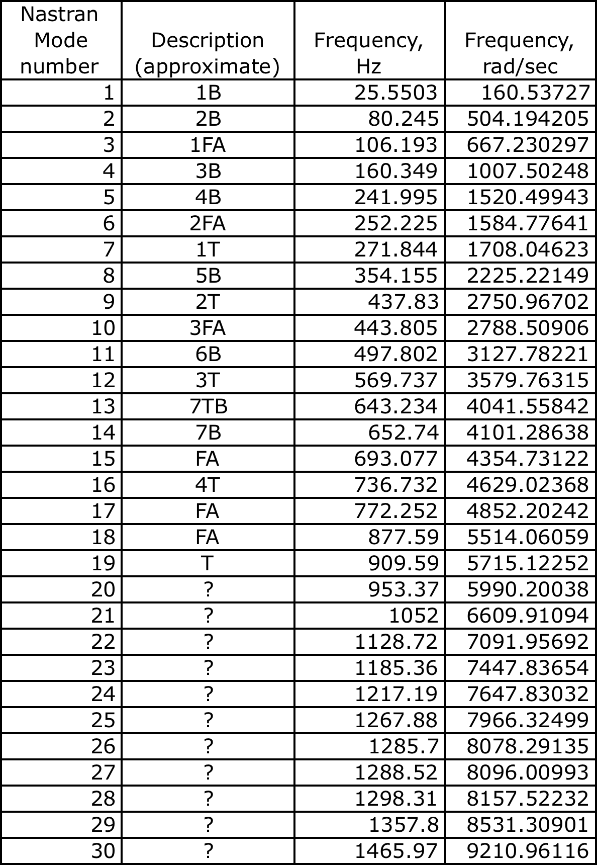
HIRENASD FEM Nov 2011
National Aeronautics and Space Administration —
Model with Tetrahedral elements includes wing, balance, exciter and modelcart Some files were too large and had to be split into parts. To combine the parts, use cat... -
Federal
NACP Soil Organic Matter of Burned Boreal Black Spruce Forests, Alaska, 2009-2011
National Aeronautics and Space Administration —
This data set provides organic soil layer characteristics, estimated carbon content, and soil depth measurements made at four black spruce stands in interior Alaska... -
Federal
ABoVE: Characterization of Burned and Unburned Spruce Forest Sites, Tanana, AK, 2017
National Aeronautics and Space Administration —
This dataset provides the results of field observations of soil characteristics and depth to permafrost, survey results for Composite Burn Index (CBI) determination,... -
Federal
Pre-LBA ISLSCP Initiative I Data
National Aeronautics and Space Administration —
This data set contains hydrology, soils, radiation, cloud, and vegetation data from the International Satellite Land Surface Climatology Project (ISLSCP) Initiative... -
Federal
Pre-LBA TRACE-A Data
National Aeronautics and Space Administration —
This data set contains atmospheric chemistry and meteorological data from the NASA Transport and Atmospheric Chemistry near the Equator-Atlantic (TRACE-A) field... -
Federal
SORCE XPS Level 4 Solar Spectral Irradiance 0.1nm Res 5-Minute V012 (SOR4XPS5) at GES DISC
National Aeronautics and Space Administration —
The SORCE XPS Level 4 Solar Spectral Irradiance 0.1nm Res 5-Minute product (SOR4XPS5) contains modelled spectral extreme ultraviolet (XUV) irradiances based on... -
Federal
ABoVE: Burn Severity, Fire Progression, Landcover and Field Data, NWT, Canada, 2014 NGDA
National Aeronautics and Space Administration —
This data set provides peatland landcover classification maps, fire progression maps, and vegetation community biophysical data collected from areas that were burned... -
Federal
NACP MCI: CO2 Emissions Inventory, Upper Midwest Region, USA., 2007
National Aeronautics and Space Administration —
This data set provides a bottom-up CO2 emissions inventory for the mid-continent region of the United States for the year 2007. The study was undertaken as part of... -
Federal
SORCE XPS Level 4 Solar Spectral Irradiance 0.1nm Res 24-Hour Means V012 (SOR4XPSD_HIGH) at GES DISC
National Aeronautics and Space Administration —
The SORCE XPS Level 4 Solar Spectral Irradiance 0.1nm Res 24-Hour Means product (SOR4XPSD_HIGH) contains modelled spectral extreme ultraviolet (XUV) irradiances based...

Official websites use .gov
A
.gov website belongs to an official government
organization in the United States.
Secure .gov websites use HTTPS
A
lock (
) or https:// means you’ve safely connected to
the .gov website. Share sensitive information only on official,
secure websites.