ABoVE: Characterization of Burned and Unburned Spruce Forest Sites, Tanana, AK, 2017
Access & Use Information
Downloads & Resources
-
Google Scholar search resultsHTML
Search results for publications that cite this dataset by its DOI.
-
Download this datasetHTML
This link allows direct data access via Earthdata login
-
View documentation related to this datasetHTML
ORNL DAAC Data Set Documentation
-
This dataset's landing pageHTML
Data set Landing Page DOI URL
-
View documentation related to this datasetZIP
ABoVE: Characterization of Burned and Unburned Spruce Forest Sites, Tanana,...
-
View documentation related to this datasetPDF
ABoVE: Soil Properties and Thaw Depth at Burned and Unburned Sites, Tanana,...
-
Get a related visualizationPNG
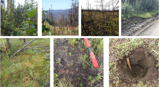
Photos from July 2017 field surveys. Clockwise from upper left photo:...
-
The dataset's project home pageHTML
ABoVE project site
-
Landing PageLanding Page
Dates
| Metadata Created Date | December 1, 2022 |
|---|---|
| Metadata Updated Date | December 6, 2023 |
Metadata Source
- Data.json Data.json Metadata
Harvested from NASA Data.json
Graphic Preview

Additional Metadata
| Resource Type | Dataset |
|---|---|
| Metadata Created Date | December 1, 2022 |
| Metadata Updated Date | December 6, 2023 |
| Publisher | ORNL_DAAC |
| Maintainer | |
| Identifier | C2162141870-ORNL_CLOUD |
| Data First Published | 2019-02-26 |
| Language | en-US |
| Data Last Modified | 2023-06-12 |
| Category | ABoVE, geospatial |
| Public Access Level | public |
| Bureau Code | 026:00 |
| Metadata Context | https://project-open-data.cio.gov/v1.1/schema/catalog.jsonld |
| Metadata Catalog ID | https://data.nasa.gov/data.json |
| Schema Version | https://project-open-data.cio.gov/v1.1/schema |
| Catalog Describedby | https://project-open-data.cio.gov/v1.1/schema/catalog.json |
| Citation | Potter, C.S., and C. Hugny. 2019. ABoVE: Characterization of Burned and Unburned Spruce Forest Sites, Tanana, AK, 2017. ORNL DAAC, Oak Ridge, Tennessee, USA. https://doi.org/10.3334/ORNLDAAC/1595 |
| Graphic Preview Description | Photos from July 2017 field surveys. Clockwise from upper left photo: Unburned forest site; burned forest landscape of the Spicer Creek Fire; High Burn Severity (HBS) forest site; eroded roadside on the margin of the Spicer Creek Fire; soil pit to 30 cm depth; charred surface organic layer of HBS site with soil probe handle; surface organic layer of unburned forest site with 1-m long soil probe (Potter & Hugny, 2018). |
| Graphic Preview File | https://daac.ornl.gov/ABOVE/guides/Wildfire_Effects_Spruce_Field_Fig1.png |
| Harvest Object Id | 81f7dd43-8647-470b-86e2-7ac4b3a3feff |
| Harvest Source Id | 58f92550-7a01-4f00-b1b2-8dc953bd598f |
| Harvest Source Title | NASA Data.json |
| Homepage URL | https://doi.org/10.3334/ORNLDAAC/1595 |
| Metadata Type | geospatial |
| Old Spatial | -152.42 65.1 -151.95 65.23 |
| Program Code | 026:001 |
| Source Datajson Identifier | True |
| Source Hash | 0d33d36508d5224517eba5c9674eb700642500da5a512d2792e784c52510f14e |
| Source Schema Version | 1.1 |
| Spatial | |
| Temporal | 2017-07-26T00:00:00Z/2017-07-28T23:59:59Z |
Didn't find what you're looking for? Suggest a dataset here.

