
-
Federal
SnowEx23 CRREL Ground Penetrating Radar Raw V001
National Aeronautics and Space Administration —
This data set contains the results of 1 GHz ground-penetrating radar surveys conducted in Alaska, USA as part of the NASA SnowEx 2023 field campaign. The study site... -
Federal
PSP FIELDS Digital Fields Board (DFB) AC-coupled V5 Antenna Voltage, Monopole Mode, Auto Spectra, High Gain, Sensor coordinates, Level 2 (L2), 0.873813 s Data
National Aeronautics and Space Administration —
PSP FIELDS Digital Fields Board, DFB, V5 data:The DFB is the low frequency, less than 75 kHz, component of the FIELDS experiment on the Parker Solar Probe spacecraft,... -
Federal
COSMOSFieldX-Ray&FIRDetectedAGNMultiwavelengthPropertiesCatalog
National Aeronautics and Space Administration —
The coeval AGN and galaxy evolution and the observed local relations between super-massive black holes (SMBHs) and galaxy properties suggest some connection or... -
Federal
MER 2 MARS HAZARD AVOID CAMERA SLOPE RDR OPS V1.0
National Aeronautics and Space Administration —
NULL -
Federal
UAVSAR_INSAR_DEM
National Aeronautics and Space Administration —
UAVSAR Repeat Pass Interferometry Scene DEM TIFF -
Federal
Rock glaciers, Zailiysiky Range, Kungei Ranges, Tienshan, Kazakhstan, Version 1
National Aeronautics and Space Administration —
The Zailiyskiy Alatau is the northernmost parallel latitudinal ranges of the Northern Tien Shan. The highest point of this range is the Talgar peak (4973 m a.s.l.).... -
Federal
SnowEx23 Mar22 IOP Snow Depth Measurements V001
National Aeronautics and Space Administration —
The data set contains snow depth measurements from two regions of Alaska, USA collected during the March 2022 intensive observation period (IOP) as part of the NASA... -
Federal
GLAS/ICESat L1B Global Waveform-based Range Corrections Data (HDF5) V034
National Aeronautics and Space Administration —
GLAH05 Level-1B waveform parameterization data include output parameters from the waveform characterization procedure and other parameters required to calculate... -
Federal
CYGNSS Level 3 Ocean Microplastic Concentration Version 3.2
National Aeronautics and Space Administration —
The CYGNSS L3 Ocean Microplastic Concentration V3.2 dataset is provided by the CYGNSS Science Team of the University of Michigan.CYGNSS was launched on 15 December... -
Federal
CYGNSS L3 Ocean Microplastic Concentration V1.0
National Aeronautics and Space Administration —
This dataset contains the version 1.0 CYGNSS level 3 ocean microplastic concentration data record, which provides 18 netCDF files, each containing one month of daily... -
Federal
IceBridge ATM L2 Icessn Elevation, Slope, and Roughness V002
National Aeronautics and Space Administration —
This data set contains resampled and smoothed elevation measurements of Arctic and Antarctic sea ice, and Greenland, Antarctic Peninsula, and West Antarctic region... -
Federal
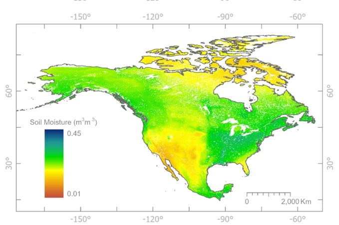
Soil Moisture Active Passive (SMAP) L1-L3 Ancillary Static Data V001
National Aeronautics and Space Administration —
This ancillary SMAP product contains more than 50 data sets. These data sets contain the inputs necessary to create SMAP products from raw instrument counts, such as... -
Federal
Near Real-Time MODIS/Terra L3 Global Daily 500m SIN Grid Snow Cover, Snow Albedo, and Snow Surface Properties, Version 1
National Aeronautics and Space Administration —
This data set contains the following parameters: snow fraction (on the ground), viewable snow fraction, snow cover duration, snow grain size, dust concentration, snow... -
Federal
Rongowai-CYGNSS Airborne Level 1 Science Data Record Version 1.0
National Aeronautics and Space Administration —
The Rongowai Level 1 Science Data Record Version 1.0 dataset is generated by the University of Auckland (UoA) Rongowai Science Payloads Operations Centre in New... -
Federal
CYGNSS Level 1 Science Data Record Version 2.1
National Aeronautics and Space Administration —
This Level 1 (L1) dataset contains the Version 2.1 geo-located Delay Doppler Maps (DDMs) calibrated into Power Received (Watts) and Bistatic Radar Cross Section... -
Federal
ABoVE: CO2 and CH4 Fluxes and Meteorology at Flux Tower Sites, Alaska, 2015-2017
National Aeronautics and Space Administration —
This dataset provides CO2 and CH4 fluxes and meteorological parameters from five eddy covariance (EC) tower sites located at Barrow (three sites), Atqasuk (ATQ) and... -
Federal
PSP FIELDS Digital Fields Board (DFB) AC-coupled Differential Voltage, V3-V4 Antennae, Dipole Mode, Spectra, High Gain, Sensor coordinates, Level 2 (L2), 0.873813 s Data
National Aeronautics and Space Administration —
PSP FIELDS Digital Fields Board, DFB, dV34hg data:The DFB is the low frequency, less than 75 kHz, component of the FIELDS experiment on the Parker Solar Probe... -
Federal
PSP FIELDS Digital Fields Board (DFB) DC-coupled Searchcoil Magnetometer, SCM, Cross Spectra, v-component, w-component, High Gain, Sensor coordinates, Level 2 (L2), 0.873813 s Data
National Aeronautics and Space Administration —
PSP FIELDS Digital Fields Board (DFB), SCMvlfhg ⨯ SCMwlfhg cross spectra data:The DFB is the low frequency, less than 75 kHz, component of the FIELDS experiment on... -
Federal
PSP FIELDS Digital Fields Board (DFB) DC-coupled Searchcoil Magnetometer, SCM, Cross Spectra, d-component, f-component, High Gain, Sensor coordinates, Level 2 (L2), 0.873813 s Data
National Aeronautics and Space Administration —
PSP FIELDS Digital Fields Board (DFB), SCMXlfhg ⨯ SCMXlfhg cross spectra data:The DFB is the low frequency, less than 75 kHz, component of the FIELDS experiment on...

Official websites use .gov
A
.gov website belongs to an official government
organization in the United States.
Secure .gov websites use HTTPS
A
lock (
) or https:// means you’ve safely connected to
the .gov website. Share sensitive information only on official,
secure websites.