
-
Federal
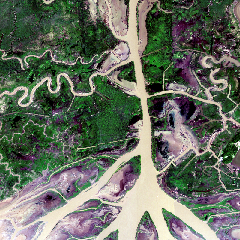
Pre-Delta-X: AVIRIS-derived Total Suspended Solids Maps for MRD, LA, USA, 2015-2016
National Aeronautics and Space Administration —
This dataset includes total suspended solids (TSS) at the water surface across the Atchafalaya and Terrebonne Basins in Southern Louisiana, USA, within the... -
Federal
Arctic Vegetation Plots, Prudhoe Bay ArcSEES Road Study, Lake Colleen, Alaska, 2014
National Aeronautics and Space Administration —
This dataset provides environmental, soil, and vegetation data collected from study plots in the vicinity of Lake Colleen off the Spine Road at Prudhoe Bay, Alaska,... -
Federal
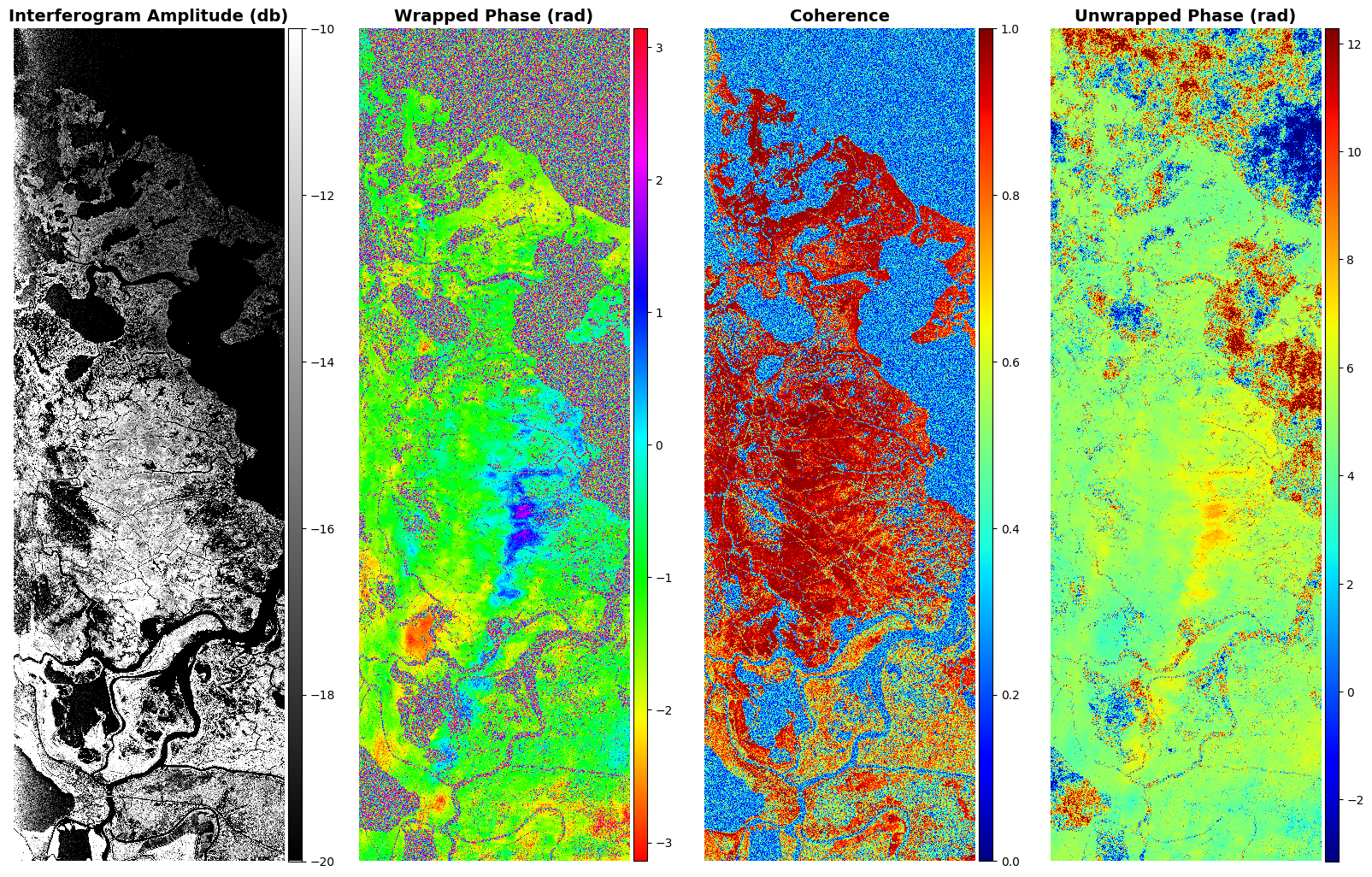
Delta-X: UAVSAR L1 Single Look Complex (SLC) Stack Products, MRD, Louisiana, 2021
National Aeronautics and Space Administration —
This dataset contains UAVSAR Level 1 (L1) Single Look Complex (SLC) stack products for Delta-X flight lines acquired during 2021-03-27 to 2021-04-18 (spring) and... -
Federal
Arctic Vegetation Plots in Northern NWT and YT, Canada, 1965-1966
National Aeronautics and Space Administration —
This dataset provides vegetation, soil, and plot characteristics for 154 study plots located at three sites across the Richardson Mountains, Northwest Territories... -
Federal
Arctic Vegetation Plots from Pingo Communities, North Slope, Alaska, 1984-1986
National Aeronautics and Space Administration —
This data set provides vegetation species and vegetation plot data collected between 1983 and 1985 from 293 study plots on 41 pingos on the North Slope of Alaska. The... -
Federal
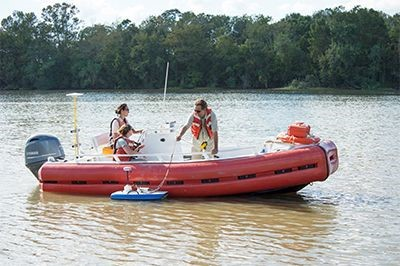
Pre-Delta-X: River Discharge Channel Surveys across Atchafalaya Basin, LA, USA, 2016
National Aeronautics and Space Administration —
This dataset provides river discharge measurements collected at selected locations across the Atchafalaya River Basin, within the Mississippi River Delta (MRD)... -
Federal
Pre-Delta-X: Spectral Reflectance of Water Surface, Atchafalaya Basin, LA, USA, 2016
National Aeronautics and Space Administration —
This dataset provides measurements of in situ remote-sensing reflectance (Rrs; per steradian) of surface water across Atchafalaya Basin, southern coastal Louisiana,... -
Federal
BOREAS TE-01 Soils Data over the SSA Tower Sites in Raster Format
National Aeronautics and Space Administration —
Gridded from vector layers of soil maps that were received from Dr. Darwin Anderson TE-01, who did the original soil mapping in the field during 1994. The vector... -
Federal
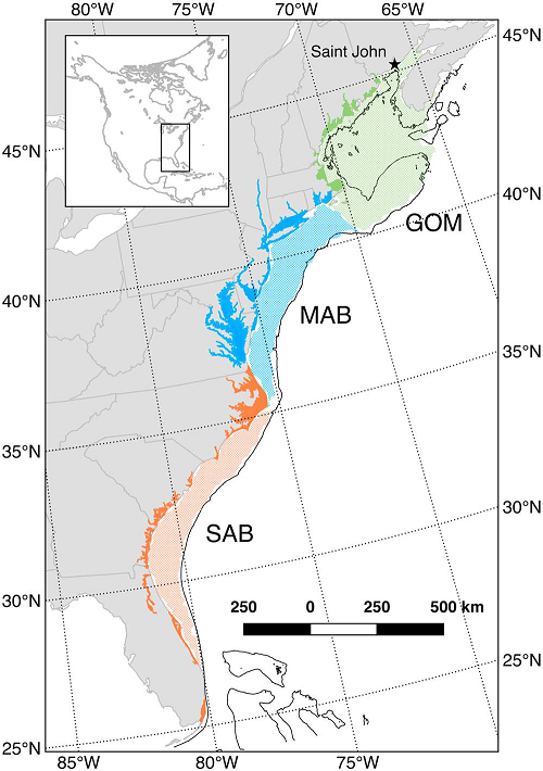
Mean Annual Fluxes of Carbon in Coastal Ecosystems of Eastern North America
National Aeronautics and Space Administration —
This dataset contains best estimates and uncertainties for mean annual fluxes of inorganic, organic, and total (organic + inorganic) carbon in tidal wetlands,... -
Federal
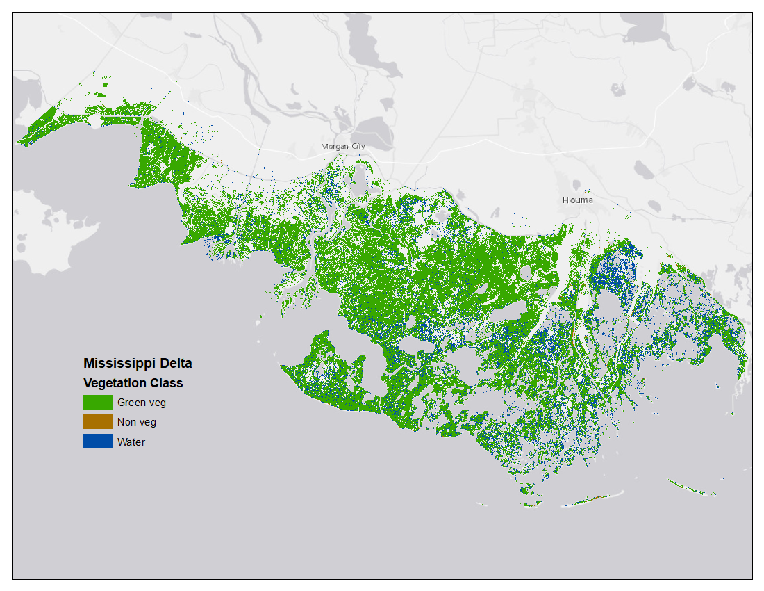
Vegetation and Open Water High-Resolution Maps for Selected US Tidal Marshes, 2015
National Aeronautics and Space Administration —
This dataset provides maps of tidal marsh green vegetation, non-vegetation, and open water for six estuarine regions of the conterminous United States: Cape Cod, MA;... -
Federal
Pre-LBA CABARE Mapped Land Surface and Vegetation Characteristics, Rondonia, Brazil
National Aeronautics and Space Administration —
Surface parameter digital maps of vegetation, soil, and topography were obtained for Rondonia, Brazil, covering the 5x5 degree region bounded by 13-8 degrees S and... -
Federal
Pre-Delta-X: Water Levels across Wax Lake Outlet, Atchafalaya Basin, LA, USA, 2016
National Aeronautics and Space Administration —
This dataset provides absolute water level elevations derived for 10 locations across the Wax Lake Delta, Atchafalaya Basin, in Southern Louisiana, USA, within the... -
Federal
Maps of Vegetation Types and Physiographic Features, Imnavait Creek, Alaska
National Aeronautics and Space Administration —
This dataset provides the spatial distribution of vegetation types, soil carbon, and physiographic features in the Imnavait Creek area, Alaska. Specific attributes... -
Federal
Delta-X: AVIRIS-NG L1B Spectral Radiance Products, MRD, Louisiana, 2021
National Aeronautics and Space Administration —
This dataset provides Level 1B (L1B) radiance products from NASA's Airborne Visible Infrared Imaging Spectrometer- Next Generation (AVIRIS-NG) instrument acquired... -
Federal
Geobotanical and Impact Map Collection for Prudhoe Bay Oilfield, Alaska, 1972-2010
National Aeronautics and Space Administration —
This data set provides a collection of maps of geoecological characteristics of areas within the Beechey Point quadrangle near Prudhoe Bay on the North slope of... -
Federal
Delta-X: UAVSAR L1B Interferometric Products, MRD, Louisiana, 2021
National Aeronautics and Space Administration —
This dataset contains UAVSAR Level 1B (L1B) interferometric products for Delta-X flight lines acquired during the 2021 Spring (2021-03-27 to 2021-04-18) and Fall... -
Federal
BOREAS TE-20 Soils Data over the NSA-MSA and Tower Sites in Vector Format
National Aeronautics and Space Administration —
Vector layers of soil maps. The vector layers were converted to ARC/INFO EXPORT files. These data cover 1-km diameters around each of the NSA tower sites and another... -
Federal
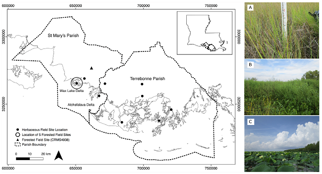
Pre-Delta-X: Vegetation Species, Structure, Aboveground Biomass, MRD, LA, USA, 2015
National Aeronautics and Space Administration —
This dataset provides vegetation species, height, stem density and diameter, and species aboveground biomass (AGB) measurements collected at herbaceous and forested... -
Federal
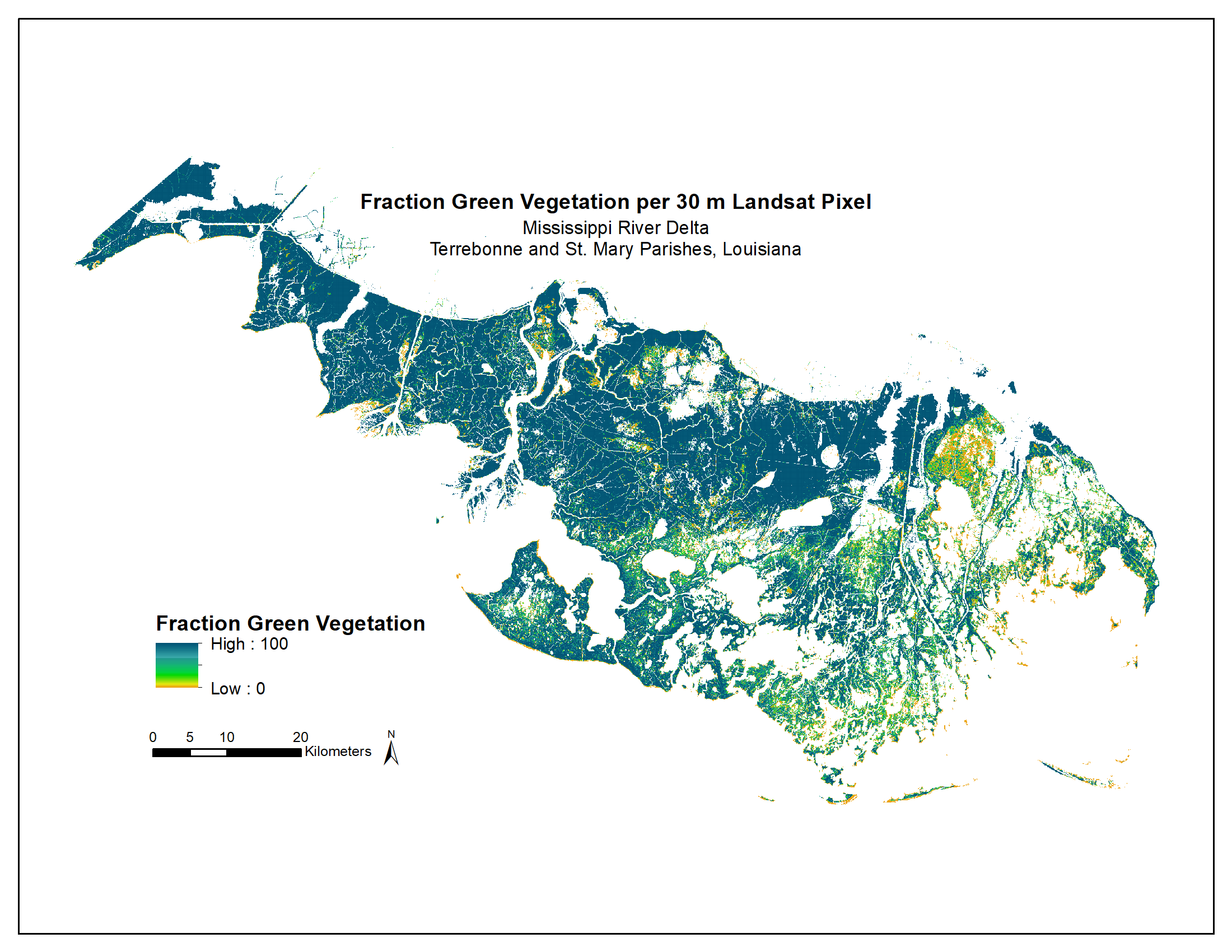
Green Vegetation Fraction High-Resolution Maps for Selected US Tidal Marshes, 2015
National Aeronautics and Space Administration —
This dataset provides 30m resolution maps of the fraction of green vegetation within tidal marshes for six estuarine regions of the conterminous United States: Cape... -
Federal
BOREAS Regional Soils Data in Raster Format and AEAC Projection
National Aeronautics and Space Administration —
This data set was gridded by BORIS staff from a vector data set received from Canadian Soil Information System (CanSIS). Data were gridded into the Albers Equal-Area...

Official websites use .gov
A
.gov website belongs to an official government
organization in the United States.
Secure .gov websites use HTTPS
A
lock (
) or https:// means you’ve safely connected to
the .gov website. Share sensitive information only on official,
secure websites.