Pre-Delta-X: Vegetation Species, Structure, Aboveground Biomass, MRD, LA, USA, 2015
Access & Use Information
Downloads & Resources
-
Google Scholar search resultsHTML
Search results for publications that cite this dataset by its DOI.
-
Download this datasetHTML
This link allows direct data access via Earthdata login
-
View documentation related to this datasetHTML
ORNL DAAC Data Set Documentation
-
This dataset's landing pageHTML
Data set Landing Page DOI URL
-
View documentation related to this datasetPDF
Pre-Delta-X: Vegetation Species, Structure, Aboveground Biomass, MRD, LA,...
-
Get a related visualizationPNG
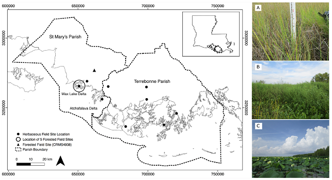
Site location map and vegetation representative in the areas. A) An example...
-
The dataset's project home pageHTML
Delta-X Project Site
-
Landing PageLanding Page
Dates
| Metadata Created Date | December 1, 2022 |
|---|---|
| Metadata Updated Date | December 7, 2023 |
Metadata Source
- Data.json Data.json Metadata
Harvested from NASA Data.json
Graphic Preview

Additional Metadata
| Resource Type | Dataset |
|---|---|
| Metadata Created Date | December 1, 2022 |
| Metadata Updated Date | December 7, 2023 |
| Publisher | ORNL_DAAC |
| Maintainer | |
| Identifier | C2025123672-ORNL_CLOUD |
| Data First Published | 2020-08-25 |
| Language | en-US |
| Data Last Modified | 2023-09-25 |
| Category | Delta-X, geospatial |
| Public Access Level | public |
| Bureau Code | 026:00 |
| Metadata Context | https://project-open-data.cio.gov/v1.1/schema/catalog.jsonld |
| Metadata Catalog ID | https://data.nasa.gov/data.json |
| Schema Version | https://project-open-data.cio.gov/v1.1/schema |
| Catalog Describedby | https://project-open-data.cio.gov/v1.1/schema/catalog.json |
| Citation | Castaneda, E., A.I. Christensen, M. Simard, A. Bevington, R. Twilley, and A. Mccall. 2020. Pre-Delta-X: Vegetation Species, Structure, Aboveground Biomass, MRD, LA, USA, 2015. ORNL DAAC, Oak Ridge, Tennessee, USA. https://doi.org/10.3334/ORNLDAAC/1805 |
| Graphic Preview Description | Site location map and vegetation representative in the areas. A) An example of Spartina which is common throughout the wetland. B) An example of the dense cover and heterogeneity of the herbaceous marsh. C) An example of floating vegetation at the study site Source: Thomas et al., 2019 |
| Graphic Preview File | https://daac.ornl.gov/DELTAX/guides/PreDeltaX_Vegetation_Structure_Fig1.png |
| Harvest Object Id | bbbc4f8a-e4d0-45e4-83a5-91fc7516e433 |
| Harvest Source Id | 58f92550-7a01-4f00-b1b2-8dc953bd598f |
| Harvest Source Title | NASA Data.json |
| Homepage URL | https://doi.org/10.3334/ORNLDAAC/1805 |
| Metadata Type | geospatial |
| Old Spatial | -91.46 29.25 -90.73 29.54 |
| Program Code | 026:001 |
| Source Datajson Identifier | True |
| Source Hash | c44138d718b88afa8589cf430fd0989734674b236a9640081396e8730406e7a6 |
| Source Schema Version | 1.1 |
| Spatial | |
| Temporal | 2015-05-06T00:00:00Z/2015-09-28T23:59:59Z |
Didn't find what you're looking for? Suggest a dataset here.

