Vegetation and Open Water High-Resolution Maps for Selected US Tidal Marshes, 2015
Access & Use Information
Downloads & Resources
-
Google Scholar search resultsHTML
Search results for publications that cite this dataset by its DOI.
-
Download this datasetHTML
This link allows direct data access via Earthdata login
-
View documentation related to this datasetHTML
ORNL DAAC Data Set Documentation
-
This dataset's landing pageHTML
Data set Landing Page DOI URL
-
View documentation related to this datasetPDF
Vegetation and Open Water High-Resolution Maps for Selected US Tidal Marshes,...
-
Get a related visualizationPNG
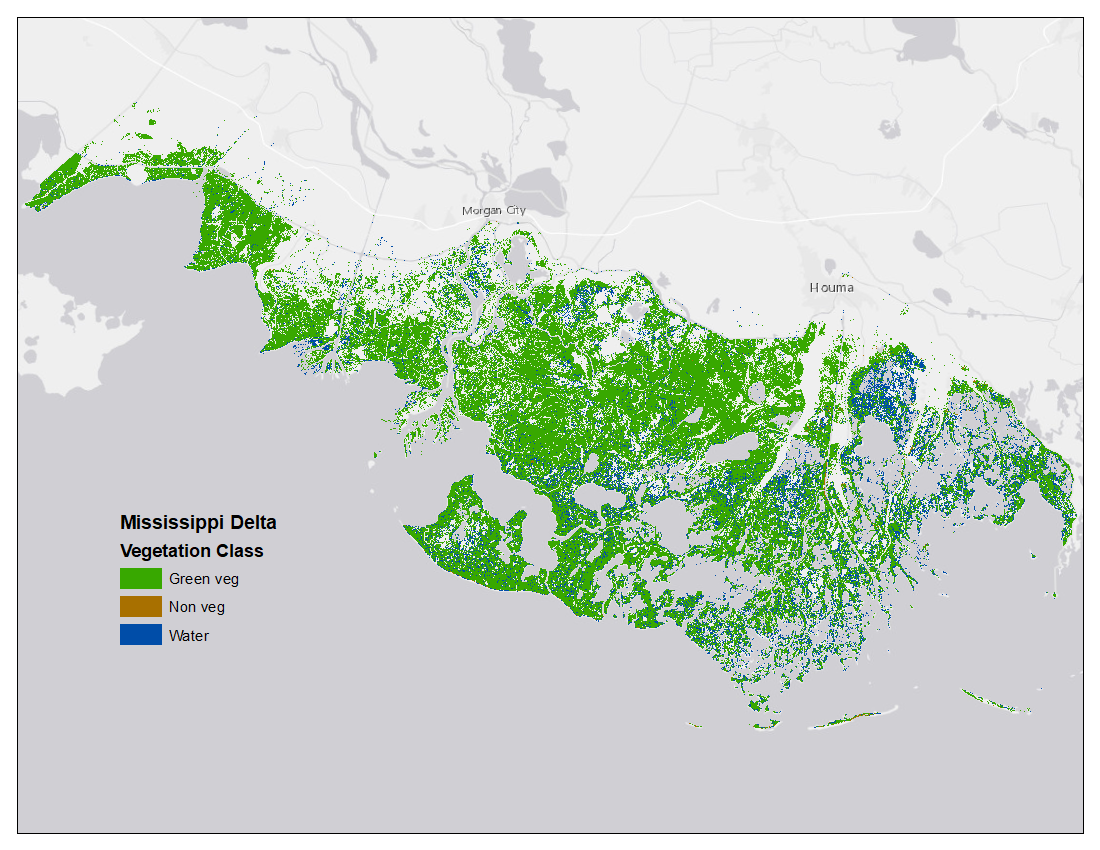
Map of tidal marsh green vegetation, non-vegetation, and open water at 1m...
-
Landing PageLanding Page
Dates
| Metadata Created Date | December 1, 2022 |
|---|---|
| Metadata Updated Date | December 7, 2023 |
Metadata Source
- Data.json Data.json Metadata
Harvested from NASA Data.json
Graphic Preview

Additional Metadata
| Resource Type | Dataset |
|---|---|
| Metadata Created Date | December 1, 2022 |
| Metadata Updated Date | December 7, 2023 |
| Publisher | ORNL_DAAC |
| Maintainer | |
| Identifier | C2389081763-ORNL_CLOUD |
| Data First Published | 2018-12-11 |
| Language | en-US |
| Data Last Modified | 2023-06-12 |
| Category | CMS, geospatial |
| Public Access Level | public |
| Bureau Code | 026:00 |
| Metadata Context | https://project-open-data.cio.gov/v1.1/schema/catalog.jsonld |
| Metadata Catalog ID | https://data.nasa.gov/data.json |
| Schema Version | https://project-open-data.cio.gov/v1.1/schema |
| Catalog Describedby | https://project-open-data.cio.gov/v1.1/schema/catalog.json |
| Citation | Ballanti, L., and K.B. Byrd. 2018. Vegetation and Open Water High-Resolution Maps for Selected US Tidal Marshes, 2015. ORNL DAAC, Oak Ridge, Tennessee, USA. https://doi.org/10.3334/ORNLDAAC/1609 |
| Graphic Preview Description | Map of tidal marsh green vegetation, non-vegetation, and open water at 1m resolution for the Mississippi River Delta site in Terrebonne and St. Mary Parishes, Louisiana. Source file: mississippidelta_Veg_1m.zip |
| Graphic Preview File | https://daac.ornl.gov/CMS/guides/High_Res_Tidal_Marsh_Veg_Fig1.png |
| Harvest Object Id | 20d444dc-86d4-4847-9993-34ab214158de |
| Harvest Source Id | 58f92550-7a01-4f00-b1b2-8dc953bd598f |
| Harvest Source Title | NASA Data.json |
| Homepage URL | https://doi.org/10.3334/ORNLDAAC/1609 |
| Metadata Type | geospatial |
| Old Spatial | -122.73 24.92 -69.93 47.12 |
| Program Code | 026:001 |
| Source Datajson Identifier | True |
| Source Hash | 29336f604bc3d9c0fa3fe171f2da3c95d065f60071006482a7d64cab787f0cde |
| Source Schema Version | 1.1 |
| Spatial | |
| Temporal | 2013-09-25T00:00:00Z/2015-08-27T23:59:59Z |
Didn't find what you're looking for? Suggest a dataset here.

