
-
Federal
Declassified Satellite Imagery 2 (2002)
National Aeronautics and Space Administration —
Declassified satellite images provide an important worldwide record of land-surface change. With the success of the first release of classified satellite photography... -
Federal
Global Roads Open Access Data Set, Version 1 (gROADSv1)
National Aeronautics and Space Administration —
The Global Roads Open Access Data Set, Version 1 (gROADSv1) was developed under the auspices of the CODATA Global Roads Data Development Task Group. The data set... -
Federal
China Dimensions Data Collection: China County-Level Data from Provincial Economic Yearbooks, Keyed to 1:1M GIS Map
National Aeronautics and Space Administration —
The China County-Level Data on Provincial Economic Yearbooks, Keyed To 1:1M GIS Map consists of socioeconomic and boundary data for the administrative regions of... -
Federal
U.S. Social Vulnerability Index Grids, Revision 01
National Aeronautics and Space Administration —
The U.S. Social Vulnerability Index Grids, Revision 01 data set contains gridded layers for the overall Centers for Disease Control and Prevention (CDC) Social... -
Federal
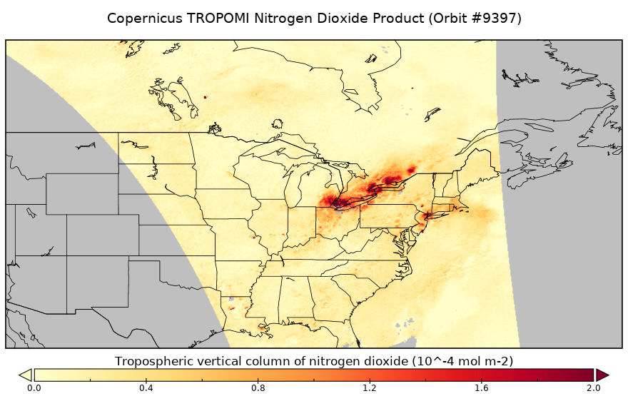
Sentinel-5P TROPOMI Tropospheric NO2 1-Orbit L2 7km x 3.5km V1 (S5P_L2__NO2___) at GES DISC
National Aeronautics and Space Administration —
Starting from August 6th in 2019, Sentinel-5P TROPOMI along-track high spatial resolution (~5.5km at nadir) has been implemented. For data after August 6th of 2019,... -
Federal
SDG Indicator 11.2.1: Urban Access to Public Transport, 2023 Release
National Aeronautics and Space Administration —
The SDG Indicator 11.2.1: Urban Access to Public Transport, 2023 Release, part of the SDGI collection, measures the proportion of the population in a city that has... -
Federal
Daily and Annual PM2.5 Concentrations for the Contiguous United States, 1-km Grids, v1 (2000 - 2016)
National Aeronautics and Space Administration —
The Daily and Annual PM2.5 Concentrations for the Contiguous United States, 1-km Grids, v1 (2000 - 2016) data set includes predictions of PM2.5 concentrations in grid... -
Federal
SDG Indicator 9.1.1: Rural Access Index (RAI), 2023 Release
National Aeronautics and Space Administration —
The SDG Indicator 9.1.1: The Rural Access Index (RAI), 2023 Release data set, part of the SDGI collection, measures the proportion of the rural population who live... -
Federal
High Mountain Asia COAWST Monthly 4km Regional Climate Model Simulations V001
National Aeronautics and Space Administration —
This data product contains either monthly averaged or monthly accumulated modeled data in the High Mountain Asia region, generated by the Coupled-Ocean-Atmosphere-... -
Federal
Daily 8-Hour Maximum and Annual O3 Concentrations for the Contiguous United States, 1-km Grids, v1 (2000 - 2016)
National Aeronautics and Space Administration —
The Daily 8-Hour Maximum and Annual O3 Concentrations for the Contiguous United States, 1-km Grids, v1 (2000 - 2016) data set contains estimates of ozone... -
Federal
Global Annual PM2.5 Grids from MODIS, MISR and SeaWiFS Aerosol Optical Depth (AOD), 1998-2019, V4.GL.03 NGDA
National Aeronautics and Space Administration —
The Global Annual PM2.5 Grids from MODIS, MISR and SeaWiFS Aerosol Optical Depth (AOD), 1998-2019, V4.GL.03 consists of annual concentrations (micrograms per cubic... -
Federal
High Mountain Asia COAWST Hourly 4km Regional Climate Model Simulations V001
National Aeronautics and Space Administration —
This data product contains either hourly accumulated or hourly snapshots of modeled data in the High Mountain Asia region, generated by the Coupled-Ocean-Atmosphere-... -
Federal
Daily and Annual PM2.5, O3, and NO2 Concentrations at ZIP Codes for the Contiguous U.S., 2000-2016, v1.0
National Aeronautics and Space Administration —
The Daily and Annual PM2.5, O3, and NO2 Concentrations at ZIP Codes for the Contiguous U.S., 2000-2016, v1.0 data set contains daily and annual concentration... -
Federal
Global Multihazard Mortality Risks and Distribution
National Aeronautics and Space Administration —
The Global Multihazard Mortality Risks and Distribution is a 2.5 minute grid identifying and characterizing the nature of multihazard risk at the global scale. For... -
Federal
Global Multihazard Frequency and Distribution
National Aeronautics and Space Administration —
The Global Multihazard Frequency and Distribution is a 2.5 minute grid presenting a simple multihazard index based solely on summated single-hazard decile values. The... -
Federal
Sentinel-5P TROPOMI Near-Real-Time (NRT) Tropospheric NO2 1-Orbit L2 5.5km x 3.5km V2 (S5P_L2__NO2____HiR_NRT) at GES DISC
National Aeronautics and Space Administration —
The Sentinel-5P TROPOMI Near Real Time (NRT) Tropospheric NO2 1-Orbit L2 5.5km x 3.5km V2 (S5P_L2__NO2_HiRNRT) at GES DISC is the near real time version of the... -
Federal
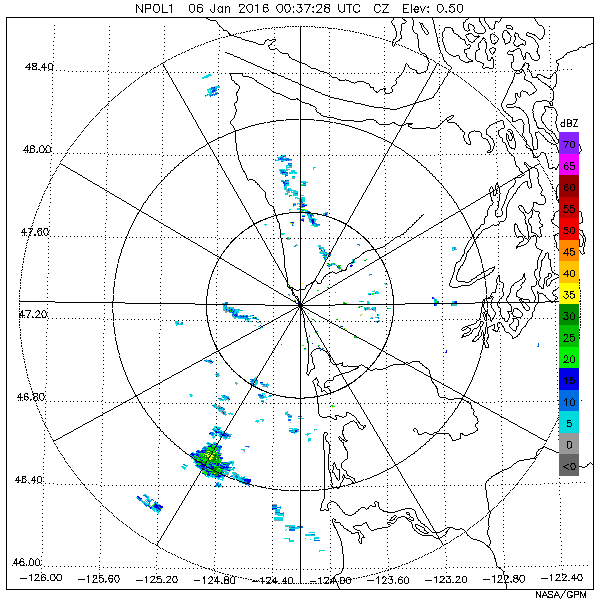
GPM Ground Validation NASA S-Band Dual Polarimetric (NPOL) Doppler Radar OLYMPEX V2
National Aeronautics and Space Administration —
The GPM Ground Validation NASA S-Band Dual Polarimetric (NPOL) Doppler Radar OLYMPEX V2 dataset consists of rain rate, reflectivity, Doppler velocity, and other radar... -
Federal
High Mountain Asia COAWST Daily 4km Regional Climate Model Simulations V001
National Aeronautics and Space Administration —
This data product contains either daily averaged or daily accumulated modeled data in the High Mountain Asia region, generated by the Coupled-Ocean-Atmosphere-Waves-...

Official websites use .gov
A
.gov website belongs to an official government
organization in the United States.
Secure .gov websites use HTTPS
A
lock (
) or https:// means you’ve safely connected to
the .gov website. Share sensitive information only on official,
secure websites.