
-
Federal
Georeferenced Population Datasets of Mexico (GEO-MEX): GIS of Mexican States, Municipalities and Islands
National Aeronautics and Space Administration —
The GIS of Mexican States, Municipalities and Islands consists of attribute and boundary data for 1990. The attribute data include population, language, education,... -
Federal
Global Fertilizer and Manure, Version 1: Nitrogen Fertilizer Application
National Aeronautics and Space Administration —
The Nitrogen Fertilizer Application data set of the Global Fertilizer and Manure, Version 1 Data Collection represents the amount of nitrogen fertilizer nutrients... -
Federal
Global Gridded Relative Deprivation Index (GRDI), Version 1
National Aeronautics and Space Administration —
The Global Gridded Relative Deprivation Index (GRDI), Version 1 (GRDIv1) data set characterizes the relative levels of multidimensional deprivation and poverty in... -
Federal
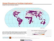
Global Fertilizer and Manure, Version 1: Phosphorus Fertilizer Application
National Aeronautics and Space Administration —
The Phosphorus Fertilizer Application data set of the Global Fertilizer and Manure, Version 1 Data Collection represents the amount of phosphorus fertilizer nutrients... -
Federal
VIIRS/NPP Surface Reflectance 8-Day L3 Global 500m SIN Grid V001
National Aeronautics and Space Administration —
The 8-day Visible Infrared Imaging Radiometer Suite (VIIRS) (https://lpdaac.usgs.gov/dataset_discovery/viirs) Surface Reflectance (VNP09H1) Version 1 composite... -
Federal
U.S. Social Vulnerability Index Grids, Revision 01
National Aeronautics and Space Administration —
The U.S. Social Vulnerability Index Grids, Revision 01 data set contains gridded layers for the overall Centers for Disease Control and Prevention (CDC) Social... -
Federal
CLASIC07 Soil Texture Data V001
National Aeronautics and Space Administration —
This data set contains soil texture data obtained for the Cloud and Land Surface Interaction Campaign 2007 (CLASIC07). The original data were extracted from a multi-... -
Federal
Alaska AVHRR Twice-Monthly Composites
National Aeronautics and Space Administration —
The goal of the Alaska Advanced Very High Resolution Radiometer (AVHRR) project is to compile a time series data set of calibrated, georegistered daily observations... -
Federal
Sounder SIPS: Suomi NPP CrIMSS Level 2 CLIMCAPS Full Spectral Resolution: Cloud Cleared Radiances V2 at GES DISC
National Aeronautics and Space Administration —
The CLIMCAPS (Community Long-term Infrared Microwave Coupled Product System) algorithm is used to analyze data from the Cross-track Infrared Sounder/Advanced... -
Federal
National Land Cover Database 2006 (NLCD2006)
National Aeronautics and Space Administration —
National Land Cover Database 2006 (NLCD2006) is a 16-class land cover classification scheme that has been applied consistently across the conterminous United States... -
Federal
Archive of Census Related Products (ACRP): 1990 Standard Extract Files
National Aeronautics and Space Administration —
The 1990 Standard Extract Files portion of the Archive of Census Related Products (ACRP) contains population and housing data derived from the U.S. Census Bureau's... -
Federal
Public Use Microdata Samples (PUMS)
National Aeronautics and Space Administration —
The Public Use Microdata Samples (PUMS) are computer-accessible files containing records for a sample of housing Units, with information on the characteristics of... -
Federal
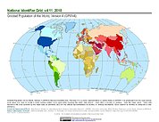
Gridded Population of the World, Version 4 (GPWv4): National Identifier Grid, Revision 11
National Aeronautics and Space Administration —
The Gridded Population of the World, Version 4 (GPWv4): National Identifier Grid, Revision 11 is a raster representation of nation-states in GPWv4 for use in... -
Federal
Georeferenced Population Datasets of Mexico (GEO-MEX): Population Database of Mexico
National Aeronautics and Space Administration —
The Population Database of Mexico contains geographically referenced population data for Mexican states, municipalities and localities from the 1990 Mexican... -
Federal
VIIRS/NPP Surface Reflectance 8-Day L3 Global 1km SIN Grid V001
National Aeronautics and Space Administration —
The 8-day Visible Infrared Imaging Radiometer Suite (VIIRS) surface reflectance (VNP09A1) Version 1 composite product provides an estimate of land surface reflectance... -
Federal
SMAPVEX08 Soil Texture Data V001
National Aeronautics and Space Administration —
This data set contains soil texture data that were extracted from a multi-layer soil characteristics database for the conterminous United States and generated for... -
Federal
CLASIC07 Soil Texture Data V001
National Aeronautics and Space Administration —
This data set contains soil texture data obtained for the Cloud and Land Surface Interaction Campaign 2007 (CLASIC07). The original data were extracted from a multi-... -
Federal
Archive of Census Related Products (ACRP): 1990 SAS Transport Files
National Aeronautics and Space Administration —
The 1990 SAS Transport Files portion of the Archive of Census Related Products (ACRP) contains housing and population data from the U.S. Census Bureau's 1990 Summary... -
Federal
SMAPVEX08 Soil Texture Data V001
National Aeronautics and Space Administration —
This data set contains soil texture data that were extracted from a multi-layer soil characteristics database for the conterminous United States and generated for... -
Federal
West Africa Coastal Vulnerability Mapping: Deforestation, 2000-2012
National Aeronautics and Space Administration —
The West Africa Coastal Vulnerability Mapping: Deforestation, 2000-2012, layer was created from the Global Forest Change data set which represents global tree cover...

Official websites use .gov
A
.gov website belongs to an official government
organization in the United States.
Secure .gov websites use HTTPS
A
lock (
) or https:// means you’ve safely connected to
the .gov website. Share sensitive information only on official,
secure websites.