
-
Federal
Georeferenced Population Datasets of Mexico (GEO-MEX): GIS of Mexican States, Municipalities and Islands
National Aeronautics and Space Administration —
The GIS of Mexican States, Municipalities and Islands consists of attribute and boundary data for 1990. The attribute data include population, language, education,... -
Federal
India Village-Level Geospatial Socio-Economic Data Set: 1991, 2001
National Aeronautics and Space Administration —
The India Village-Level Geospatial Socio-Economic Data Set: 1991, 2001 is a compilation of the finest level of administrative boundaries in India (village/town-level)... -
Federal
Georeferenced Population Datasets of Mexico (GEO-MEX): Urban Place GIS Coverage of Mexico
National Aeronautics and Space Administration —
The Urban Place GIS Coverage of Mexico is a vector based point Geographic Information System (GIS) coverage of 696 urban places in Mexico. Each Urban Place is... -
Federal
Archive of Census Related Products (ACRP): 1990 Standard Extract Files
National Aeronautics and Space Administration —
The 1990 Standard Extract Files portion of the Archive of Census Related Products (ACRP) contains population and housing data derived from the U.S. Census Bureau's... -
Federal
NLCD 2001 Version 2
National Aeronautics and Space Administration —
National Land Cover Database 2001 (NLCD2001) is a 16-class (additional four classes in Alaska only) land cover classification scheme that has been applied... -
Federal
AIRSAR_TOPSAR_P-BAND_STOKES
National Aeronautics and Space Administration —
AIRSAR topographic SAR digital elevation model P_Stokes product -
Federal
Archive of Census Related Products (ACRP): 1992 Boundary Files
National Aeronautics and Space Administration —
The 1992 Boundary Files portion of the Archive of Census Related Products (ACRP) consists of 1992 boundary data from the U.S. Census Bureau's Topologically Integrated... -
Federal
Georeferenced Population Datasets of Mexico (GEO-MEX): Raster Based GIS Coverage of Mexican Population
National Aeronautics and Space Administration —
The Raster Based GIS Coverage of Mexican Population is a gridded coverage (1 x 1 km) of Mexican population. The data were converted from vector into raster. The... -
Federal
Alaska AVHRR Twice-Monthly Composites
National Aeronautics and Space Administration —
The goal of the Alaska Advanced Very High Resolution Radiometer (AVHRR) project is to compile a time series data set of calibrated, georegistered daily observations... -
Federal
UAVSAR_POLSAR_ML_COMPLEX_GRD
National Aeronautics and Space Administration —
UAVSAR PolSAR Scene Projected -
Federal
UAVSAR_INSAR_AMPLITUDE_GRD
National Aeronautics and Space Administration —
UAVSAR Repeat Pass Interferometry Ground Projected Amplitude Scene -
Federal
UAVSAR_POLSAR_DEM
National Aeronautics and Space Administration —
UAVSAR PolSAR Scene DEM TIFF -
Federal
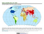
Gridded Population of the World, Version 4 (GPWv4): National Identifier Grid, Revision 11
National Aeronautics and Space Administration —
The Gridded Population of the World, Version 4 (GPWv4): National Identifier Grid, Revision 11 is a raster representation of nation-states in GPWv4 for use in... -
Federal
UAVSAR_POLSAR_ML_COMPLEX_GRD_5X5
National Aeronautics and Space Administration —
UAVSAR PolSAR Scene Projected Multilook 5x5 -
Federal
2015 Urban Extents from VIIRS and MODIS for the Continental U.S. Using Machine Learning Methods NGDA
National Aeronautics and Space Administration —
The 2015 Urban Extents from VIIRS and MODIS for the Continental U.S. Using Machine Learning Methods data set models urban settlements in the Continental United States... -
Federal
UAVSAR_POLSAR_SLOPE
National Aeronautics and Space Administration —
UAVSAR PolSAR Scene Slope -
Federal
AIRSAR_TOPSAR_DEM_C
National Aeronautics and Space Administration —
AIRSAR topographic SAR digital elevation model CTIF product -
Federal
AIRSAR_TOPSAR_L-BAND_STOKES
National Aeronautics and Space Administration —
AIRSAR topographic SAR digital elevation model L_Stokes product -
Federal
AIRSAR_TOPSAR_DEM_P
National Aeronautics and Space Administration —
AIRSAR topographic SAR digital elevation model PTIF product

Official websites use .gov
A
.gov website belongs to an official government
organization in the United States.
Secure .gov websites use HTTPS
A
lock (
) or https:// means you’ve safely connected to
the .gov website. Share sensitive information only on official,
secure websites.