
-
Federal
ABoVE: Thaw Depth at Selected Unburned and Burned Sites Across Alaska
National Aeronautics and Space Administration —
This dataset provides thaw depth measurements made at seven locations across Alaska, during August 2016, June and September 2017, and July-August 2018. Three of the... -
Federal
FIFE CDROM Vol. 3 Contents: NS001 Thematic Mapper Simulator (TMS) Imagery, 1987-1989
National Aeronautics and Space Administration —
This data set provides aircraft-based NS001 Thematic Mapper Simulator (TMS) images of the study area associated with The First ISLSCP (International Satellite Land... -
Federal
A Global Database of Gas Fluxes from Soils after Rewetting or Thawing, Version 1.0
National Aeronautics and Space Administration —
This database contains information compiled from published studies on gas flux from soil following rewetting or thawing. The resulting database includes 222 field and... -
Federal
Tundra Plant Reflectance, CO2 Exchange, PAM Fluorometry, and Pigments, AK, 2001-2002
National Aeronautics and Space Administration —
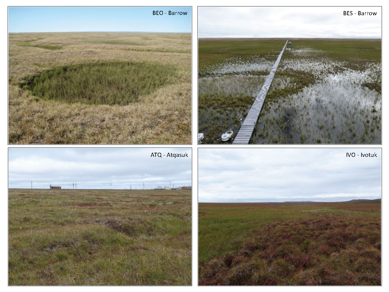
This dataset provides measurements at tundra plots collected near Utqiagvik and Atqasuk, AK, including visible-near infrared spectral reflectance, chamber gas... -
Federal
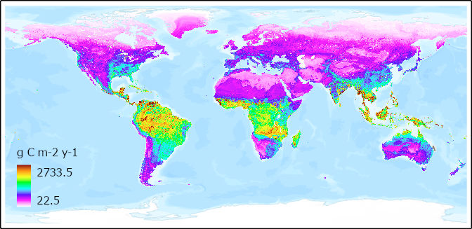
Global Gridded 1-km Soil and Soil Heterotrophic Respiration Derived from SRDB v5
National Aeronautics and Space Administration —
This dataset provides global gridded estimates of annual soil respiration (Rs) and soil heterotrophic respiration (Rh) and associated uncertainties at 1 km... -
Federal
Burned and Unburned Field Site Data, Noatak, Seward, and North Slope, AK, 2016-2018
National Aeronautics and Space Administration —
This dataset includes field measurements from unburned and burned 10 m x 10 m and 1 m x 1 m plots in the Noatak, Seward, and North Slope regions of the Alaskan tundra... -
Federal
Arctic Vegetation Plots at Umiat, North Slope, Alaska, 1951
National Aeronautics and Space Administration —
This data set provides vegetation cover and plot data collected during the periods of July and August, 1951, from 51 stands (areas of homogeneous vegetation... -
Federal
Arctic Vegetation Plots in Flux Tower Footprints, North Slope, Alaska, 2014
National Aeronautics and Space Administration —
This data set provides vegetation, environmental, and soil data collected from plots located in the footprints of eddy covariance flux towers along a 300 km north-... -
Federal
ABoVE: Post-Fire and Unburned Vegetation Community and Field Data, NWT, Canada, 2017
National Aeronautics and Space Administration —
This dataset provides vegetation community characteristics, soil moisture, and biophysical data collected in 2017 from 11 study sites in the ABoVE Study area. The 11... -
Federal
ABoVE: Post-Fire and Unburned Vegetation Community and Field Data, NWT, Canada, 2018
National Aeronautics and Space Administration —
This dataset provides vegetation community characteristics and biophysical data collected in 2018 from areas that were burned by wildfire in 2014 and 2015, and from... -
Federal
Arctic Vegetation Plots at ARCSS/LAII Flux Sites, North Slope, Alaska, 1995-1996
National Aeronautics and Space Administration —
This dataset provides vegetation cover and environmental plot and soil data collected at flux tower sites of the North Slope Arctic System Science/Land-Atmosphere-Ice... -
Federal
ABoVE: Active Layer Soil Characteristics at Selected Sites Across Alaska
National Aeronautics and Space Administration —
This dataset provides soil active layer characteristics from nine locations across Alaska. Soil samples were collected in 2016 except for one site which was sampled... -
Federal
ABoVE: Post-Fire and Unburned Vegetation Community and Field Data, NWT, Canada, 2019
National Aeronautics and Space Administration —
This dataset provides vegetation community characteristics, soil moisture, and biophysical data collected in 2019 from 11 study areas, which contained 28 sites that... -
Federal
Greenness Trends and Carbon Stocks of Mangrove Forests Across Mexico, 2001-2015 NGDA
National Aeronautics and Space Administration —
This dataset provides estimates of greenness trends, above- and belowground carbon stocks, and climate variables of the persistent mangrove forests on the coasts of... -
Federal
Global Gridded Surfaces of Selected Soil Characteristics (IGBP-DIS)
National Aeronautics and Space Administration —
Global data-surfaces pre-generated by SoilData, at a resolution of 5x5 arc-minutes, in ASCII GRID format for ARC INFO, and for the soil depth interval 0-100 cm. -
Federal
Arctic Vegetation Plots in NPS Arctic Network Parks, Alaska, 2002-2008
National Aeronautics and Space Administration —
This dataset provides environmental, soil, and vegetation data collected at selected locations in the parks and preserves of the National Park Service (NPS) Arctic... -
Federal
Global Soil Types, 0.5-Degree Grid (Modified Zobler)
National Aeronautics and Space Administration —
A global data set of soil types is available at 0.5-degree latitude by 0.5-degree longitude resolution. There are 106 soil units, based on Zobler's (1986) assessment... -
Federal
Arctic Vegetation Plots in Willow Communities, North Slope, Alaska, 1997
National Aeronautics and Space Administration —
This data set provides environmental, soil, and vegetation data collected in July and August 1997 from 85 study plots in willow shrub communities located along a... -
Federal
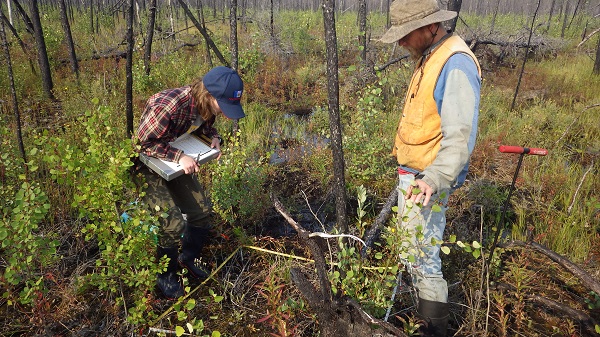
ABoVE: Characterization of Carbon Dynamics in Burned Forest Plots, NWT, Canada, 2014
National Aeronautics and Space Administration —
This dataset provides field data from boreal forests in the Northwest Territories (NWT), Canada, that were burned by wildfires in 2014. During fieldwork in 2015, 211... -
Federal
Characteristics of African Savanna Biomes for Determining Woody Cover
National Aeronautics and Space Administration —
This data set includes the soil and vegetation characteristics, herbivore estimates, and precipitation measurement data for the 854 sites described and analyzed in...

Official websites use .gov
A
.gov website belongs to an official government
organization in the United States.
Secure .gov websites use HTTPS
A
lock (
) or https:// means you’ve safely connected to
the .gov website. Share sensitive information only on official,
secure websites.