ABoVE: Post-Fire and Unburned Vegetation Community and Field Data, NWT, Canada, 2017
Access & Use Information
Downloads & Resources
-
Google Scholar search resultsHTML
Search results for publications that cite this dataset by its DOI.
-
Download this datasetHTML
This link allows direct data access via Earthdata login
-
View documentation related to this datasetHTML
ORNL DAAC Data Set Documentation
-
This dataset's landing pageHTML
Data set Landing Page DOI URL
-
View documentation related to this datasetPDF
ABoVE: Post-Fire and Unburned Vegetation Community and Field Data, NWT,...
-
Get a related visualizationJPEG
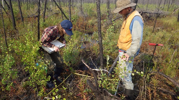
Researchers collecting data on vegetation and biophysical characteristics at...
-
The dataset's project home pageHTML
ABoVE project site
-
Landing PageLanding Page
Dates
| Metadata Created Date | December 1, 2022 |
|---|---|
| Metadata Updated Date | December 6, 2023 |
Metadata Source
- Data.json Data.json Metadata
Harvested from NASA Data.json
Graphic Preview

Additional Metadata
| Resource Type | Dataset |
|---|---|
| Metadata Created Date | December 1, 2022 |
| Metadata Updated Date | December 6, 2023 |
| Publisher | ORNL_DAAC |
| Maintainer | |
| Identifier | C2308231345-ORNL_CLOUD |
| Data First Published | 2022-06-24 |
| Language | en-US |
| Data Last Modified | 2023-06-12 |
| Category | ABoVE, geospatial |
| Public Access Level | public |
| Bureau Code | 026:00 |
| Metadata Context | https://project-open-data.cio.gov/v1.1/schema/catalog.jsonld |
| Metadata Catalog ID | https://data.nasa.gov/data.json |
| Schema Version | https://project-open-data.cio.gov/v1.1/schema |
| Catalog Describedby | https://project-open-data.cio.gov/v1.1/schema/catalog.json |
| Citation | Bourgeau-Chavez, L.L., S.E. Grelick, N.H.F. French, D. Tanzer, and E.S. Kane. 2022. ABoVE: Post-Fire and Unburned Vegetation Community and Field Data, NWT, Canada, 2017. ORNL DAAC, Oak Ridge, Tennessee, USA. https://doi.org/10.3334/ORNLDAAC/1771 |
| Graphic Preview Description | Researchers collecting data on vegetation and biophysical characteristics at a study site in Northwest Territories of Canada that was burned by wildfires in 2014-2015. |
| Graphic Preview File | https://daac.ornl.gov/ABOVE/guides/ABoVE_NWT_2017_Field_Data_Fig1.jpg |
| Harvest Object Id | 4d7d1572-cc8f-4a0c-92b2-9acfaf4a9433 |
| Harvest Source Id | 58f92550-7a01-4f00-b1b2-8dc953bd598f |
| Harvest Source Title | NASA Data.json |
| Homepage URL | https://doi.org/10.3334/ORNLDAAC/1771 |
| Metadata Type | geospatial |
| Old Spatial | -117.38 60.52 -111.37 62.58 |
| Program Code | 026:001 |
| Source Datajson Identifier | True |
| Source Hash | 7d9aa9f4ed001130449ce9110977d7a73e7d70265141fb52d04cc514ef5ad59f |
| Source Schema Version | 1.1 |
| Spatial | |
| Temporal | 2015-07-13T00:00:00Z/2017-08-10T23:59:59Z |
Didn't find what you're looking for? Suggest a dataset here.

