
-
VIIRS/NPP Day/Night Band Terrain Corrected Geolocation L1 6-Min Swath 750 m recent views
The VIIRS/NPP Day/Night Band Terrain Corrected Geolocation 6-Min L1 Swath 750m product, short-name VNP03DNB includes the geolocation fields that are calculated for Visible-... -
TEMPEST STP-H8 Antenna and Microwave Brightness Temperatures Version 10.0 recent views
!!!Temporary notice posted Sept. 27th, 2024!!! These data are in the process of being ingested and not all files are available yet. The data were made public early to allow... -
OMI/Aura Formaldehyde (HCHO) Total Column Daily L3 Weighted Mean Global 0.1deg Lat/Lon Grid V003 (OMHCHOd) at GES DISC recent views
The OMI/Aura Formaldehyde (HCHO) Total Column Daily L3 Weighted Mean Global 0.1deg Lat/Lon Grid (OMHCHOd). The formaldehyde values in each file are the average for 0.1 x 0.1... -
Diagnosing Faults in Electrical Power Systems of Spacecraft and Aircraft recent views
Electrical power systems play a critical role in spacecraft and aircraft, and they exhibit a rich variety of failure modes. This paper discusses electrical power system fault... -
NLDAS Secondary Forcing Data L4 Hourly 0.125 x 0.125 degree V2.0 (NLDAS_FORB0125_H) at GES DISC recent views
This data set contains the secondary forcing hourly data "File B" for Phase 2 of the North American Land Data Assimilation System (NLDAS-2). The data are in 1/8th degree grid... -
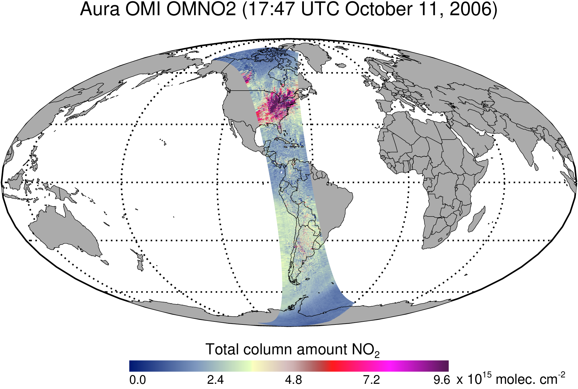
OMI/Aura Nitrogen Dioxide (NO2) Total and Tropospheric Column 1-orbit L2 Swath 13x24 km V003 (OMNO2) at GES DISC recent views
The Version 4.0 Aura Ozone Monitoring Instrument (OMI) Nitrogen Dioxide (NO2) Standard Product (OMNO2) is now available from the NASA Goddard Earth Sciences Data and Information... -
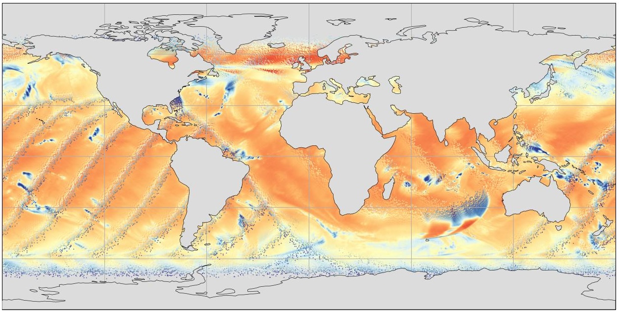
GHRSST Level 4 MUR Global Foundation Sea Surface Temperature Analysis (v4.1) NGDA recent views
A Group for High Resolution Sea Surface Temperature (GHRSST) Level 4 sea surface temperature analysis produced as a retrospective dataset (four day latency) and near-real-time... -
AMSR2/GCOM-W1 surface soil moisture (LPRM) L3 1 day 10 km x 10 km ascending V001 (LPRM_AMSR2_DS_A_SOILM3) at GES DISC recent views
AMSR2/GCOM-W1 surface soil moisture (LPRM) L3 1 day 10 km x 10 km ascending V001 is a Level 3 (gridded) data set. Its land surface parameters, surface soil moisture, land... -
Smerge-Noah-CCI root zone soil moisture 0-40 cm L4 daily 0.125 x 0.125 degree V2.0 (SMERGE_RZSM0_40CM) at GES DISC recent views
Smerge-Noah-CCI root zone soil moisture 0-40 cm L4 daily 0.125 x 0.125 degree V2.0 is a multi-decadal root-zone soil moisture product. Smerge is developed by merging the North... -
NACP Integrated Wildland and Cropland 30-m Fuel Characteristics Map, U.S.A., 2010 recent views
The data set provides a 30-m comprehensive fuelbed characteristics map for both the wildland and cropland areas of the conterminous United States (CONUS) for 2010. This... -
GEOS-Carb CASA-GFED Monthly Fire Fuel NPP Rh NEE Fluxes 0.5 degree x 0.5 degree V3 (GEOS_CASAGFED_M_FLUX) at GES DISC recent views
This product provides Monthly average Net Primary Production (NPP), heterotrophic respiration (Rh), wildfire emissions (FIRE), and fuel wood burning emissions (FUEL) derived... -
Automated Discovery of Flight Track Anomalies recent views
As new technologies are developed to handle the complexities of the Next Generation Air Transportation System (NextGen), it is increasingly important to address both current and... -
Distributed Data Mining in Peer-to-Peer Networks recent views
Peer-to-peer (P2P) networks are gaining popularity in many applications such as file sharing, e-commerce, and social networking, many of which deal with rich, distributed data... -
Delta-X AVIRIS-NG L3 Derived Vegetation Types, MRD, Louisiana, USA recent views
This dataset provides maps of vegetation types for the Atchafalaya and Terrebonne basins in coastal Louisiana, U.S., derived from NASA's Next Generation Airborne Visible... -
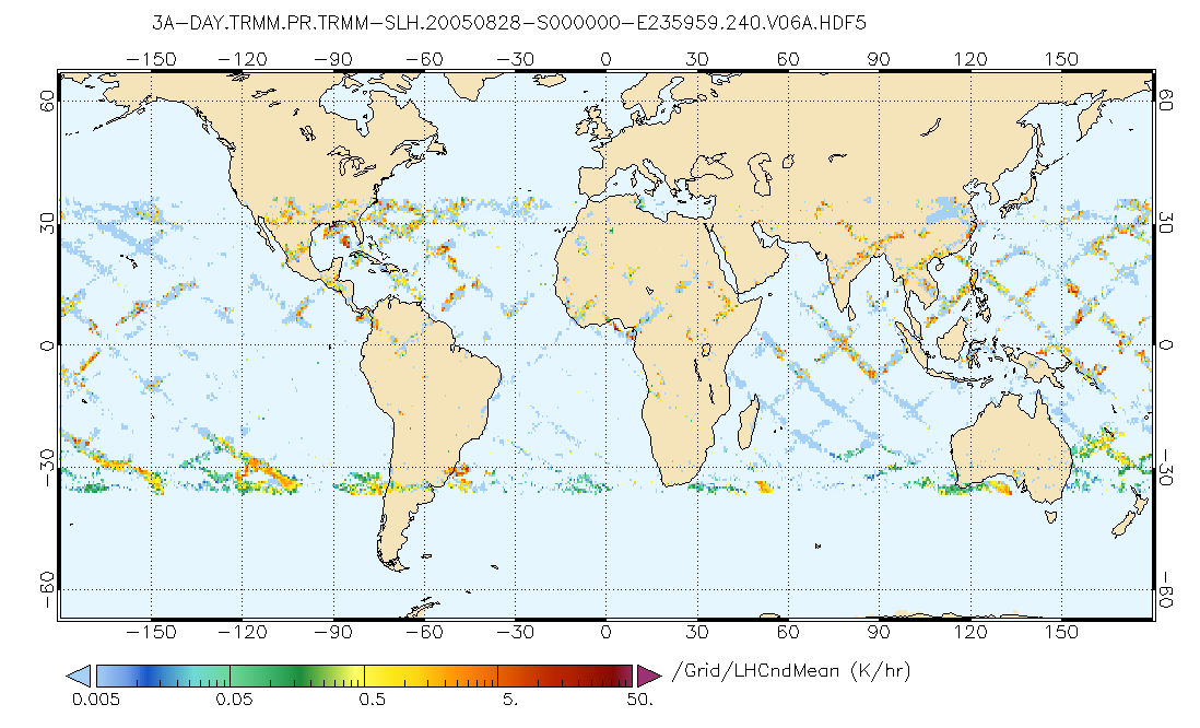
GPM PR on TRMM Spectral Latent Heating Profiles L3 1 Day 0.5x0.5 degree V07 (GPM_3HSLH_TRMM_DAY) at GES DISC recent views
This a new (GPM-formated) TRMM product. There is no equivalent in the old TRMM suite of products. Version 07 is the current version of the data set. Older versions will no... -
NASA Shuttle Radar Topography Mission Global 1 arc second Number NetCDF V003 recent views
The Land Processes Distributed Active Archive Center (LP DAAC) is responsible for the archive and distribution of the NASA Making Earth System Data Records for Use in Research... -
Fleet Level Anomaly Detection of Aviation Safety Data recent views
For the purposes of this paper, the National Airspace System (NAS) encompasses the operations of all aircraft which are subject to air traffic control procedures. The NAS is a... -
OMI/Aura Sulfur Dioxide (SO2) Total Column Daily L3 1 day Best Pixel in 0.25 degree x 0.25 degree V3 (OMSO2e) at GES DISC recent views
The OMI science team produces this Level-3 Aura/OMI Global OMSO2e Data Products (0.25 degree Latitude/Longitude grids). In this Level-3 daily global SO2 data product, each grid... -
FLDAS Noah Land Surface Model L4 Global Monthly 0.1 x 0.1 degree (MERRA-2 and CHIRPS) V001 (FLDAS_NOAH01_C_GL_M) at GES DISC recent views
This dataset contains a series of land surface parameters simulated from the Noah 3.6.1 model in the Famine Early Warning Systems Network (FEWS NET) Land Data Assimilation...

Official websites use .gov
A
.gov website belongs to an official government
organization in the United States.
Secure .gov websites use HTTPS
A
lock (
) or https:// means you’ve safely connected to
the .gov website. Share sensitive information only on official,
secure websites.