
-
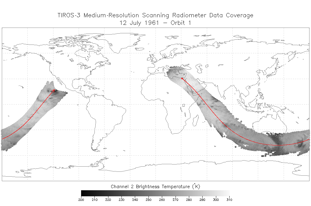
TIROS-3 Medium-Resolution Scanning Radiometer Level 1 Final Meteorological Radiation Data V001 (TIROS3L1FMRT) at GES DISC
TIROS-3 Medium-Resolution Scanning Radiometer Level 1 Final Meteorological Radiation Data (FMRT) product contains radiances expressed in five infrared/visible wavelength... -
TES/Aura L2 Instantaneous Radiative Kernel Nadir Special Observation V008
TL2IRKNS_8 is the Tropospheric Emission Spectrometer (TES)/Aura Level 2 Instantaneous Radiative Kernel Nadir Special Observation Version 8 data product. TES was an instrument... -
TES/Aura L2 Deuterium Oxide Lite Nadir V007
TL2HDOLN_7 is the Tropospheric Emission Spectrometer (TES)/Aura Level 2 Deuterium Oxide Lite Nadir Version 7 data product. TES was an instrument aboard NASA's Aura satellite and... -
TEMPO gridded formaldehyde total column V03 (PROVISIONAL)
Formaldehyde Level 3 files provide trace gas information on a regular grid covering the TEMPO field of regard for nominal TEMPO observations. Level 3 files are derived by... -
TEMPO geolocated Earth radiances V03 (PROVISIONAL)
Level 1 radiance files provide radiance information at TEMPO’s native spatial resolution, ~10 km^2 at the center of the Field of Regard (FOR), for individual granules. Each... -
Synthesis of Winter In Situ Soil CO2 Flux in pan-Arctic and Boreal Regions, 1989-2017
This dataset provides a synthesis of winter ( September-April) in situ soil CO2 flux measurement data from locations across pan-Arctic and Boreal permafrost regions. The in situ... -
Primary Ancillary Data Geo-Colocated to OMI/Aura UV2 1-Orbit L2 Swath 13x24km V4 (OMUANC) at GES DISC
The Primary Ancillary Data Geo-Colocated to OMI/Aura UV2 1-Orbit L2 Swath 13x24km (OMUANC) provides selected parameters from GEOS-5 Forward Processing for Instrument Teams (FP-... -
Portable Remote Imaging SpectroMeter (PRISM) from Elkhorn Slough to Monterey Bay, California
The estuarine waters of Elkhorn Slough terminating in Monterey Bay, California present an excellent study site for testing the limits of hyperspectral imaging spectroscopy in a... -
Portable Remote Imaging Spectrometer (PRISM) COral Reef Airborne Laboratory (CORAL) Regional Reflectance Data
Flight line reflectance measurements from the Portable Remote Imaging Spectrometer (PRISM) instrument aboard the Tempus Applied Solutions Gulfstream-IV (G-IV) aircraft, taken as... -
Paleo-periglacial phenomena in Northwestern Europe, Version 1
This data set includes site descriptions of paleoperiglacial features and related paleoclimatic data for Europe, including radiocarbon dating. Data have been extracted from... -
Panama City, Florida optical measurements in 1993
Measurements taken in the Gulf of Mexico near Panama City, Florida in 1993. -
Optical Thickness Data: Bruegge (FIFE)
The NIPS and Reagan Sunphotometer Optical Thickness study compared various ground and image-based techniques used to characterize the atmosphere. These data are used to remove... -
Optical Thickness Data: C-130 (FIFE)
The data in the Sunphotometer Optical Thickness Data from C130 Aircraft data set were collected in June, July and August 1987, and in August 1989. The data was collected at... -
OMPS-NPP L1G LP Radiance EV Wavelength-Altitude Grid swath orbital 3slit V2.6 (OMPS_NPP_LP_L1G_EV) at GES DISC
The OMPS-NPP L1G LP Radiance EV Wavelength-Altitude Grid swath orbital 3slit product contains the calibrated earth-viewing radiances measured by the Ozone Mapping and Profiling...

Official websites use .gov
A
.gov website belongs to an official government
organization in the United States.
Secure .gov websites use HTTPS
A
lock (
) or https:// means you’ve safely connected to
the .gov website. Share sensitive information only on official,
secure websites.