
-
Vulcan: High-Resolution Hourly Fossil Fuel CO2 Emissions in USA, 2010-2015, Version 3 recent views
The Vulcan version 3.0 hourly dataset quantifies hourly emissions at a 1-km resolution for the 2010-2015 time period. Estimates are provided of hourly carbon dioxide (CO2)... -
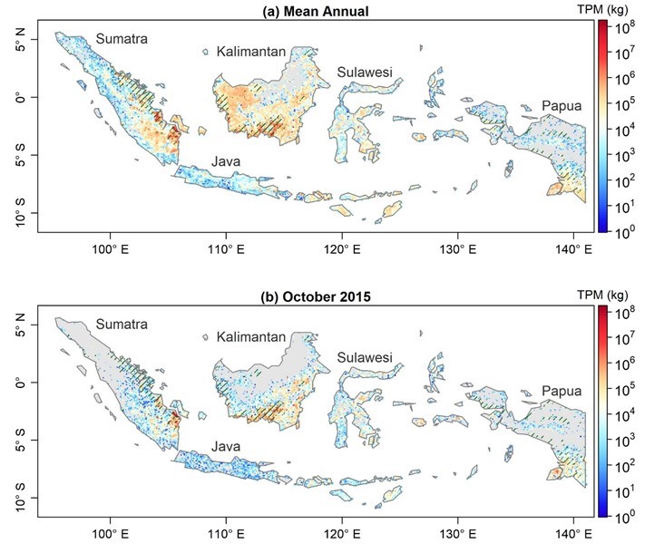
Fire Particulate Emissions from Combined VIIRS and AHI Data for Indonesia, 2015-2020 recent views
This dataset provides 10-minute fire emissions within 0.1-degree regularly spaced intervals across Indonesia from July 2015 to December 2020. The dataset was produced with a... -
Methane Plumes Derived from AVIRIS-NG over Point Sources across California, 2016-2017 recent views
This dataset provides maps of methane (CH4) plumes along flight lines over identified methane point-source emitting infrastructure across the State of California, USA collected... -
NACP MCI: CO2 Emissions Inventory, Upper Midwest Region, USA., 2007 recent views
This data set provides a bottom-up CO2 emissions inventory for the mid-continent region of the United States for the year 2007. The study was undertaken as part of the North... -
Geoecology: County-Level Environmental Data for the United States, 1941-1981 recent views
The Geoecology database is a compilation of environmental data for the period 1941 to 1981. The Geoecology database contains selected data on terrain and soils, water resources,... -
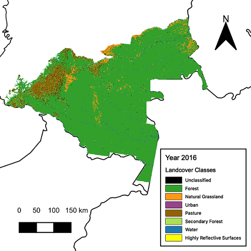
CMS: Landsat-derived Annual Land Cover Maps for the Colombian Amazon, 2001-2016 recent views
This dataset provides annual maps of land cover classes for the Colombian Amazon from 2001 through 2016 that were created by classifying time segments detected by the Continuous... -
LBA-ECO LC-39 MODIS Active Fire and Frequency Data for South America: 2000-2007 NGDA recent views
This data set provides active fire locations and estimates of annual fire frequencies for South America from 2000-2007. Data from the Moderate Resolution Imaging... -
ISLSCP II Global Population of the World NGDA recent views
Global Population of the World (GPW) translates census population data to a latitude-longitude grid so that population data may be used in cross-disciplinary studies. There are... -
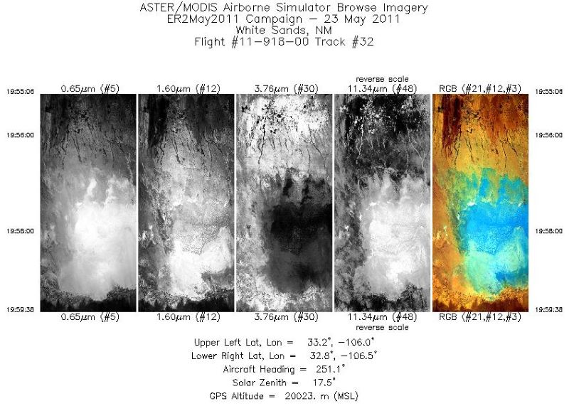
MASTER: Student Airborne Research Program (SARP) campaign, California, USA, 2016 recent views
This dataset includes Level 1B (L1B) data products from the MODIS/ASTER Airborne Simulator (MASTER) instrument collected and developed by the Student Airborne Research Program... -
ATom: Merged Atmospheric Chemistry, Trace Gases, and Aerosols recent views
This dataset provides information on greenhouse gases and human-produced air pollution, including atmospheric concentrations of carbon dioxide (CO2), methane (CH4), tropospheric... -
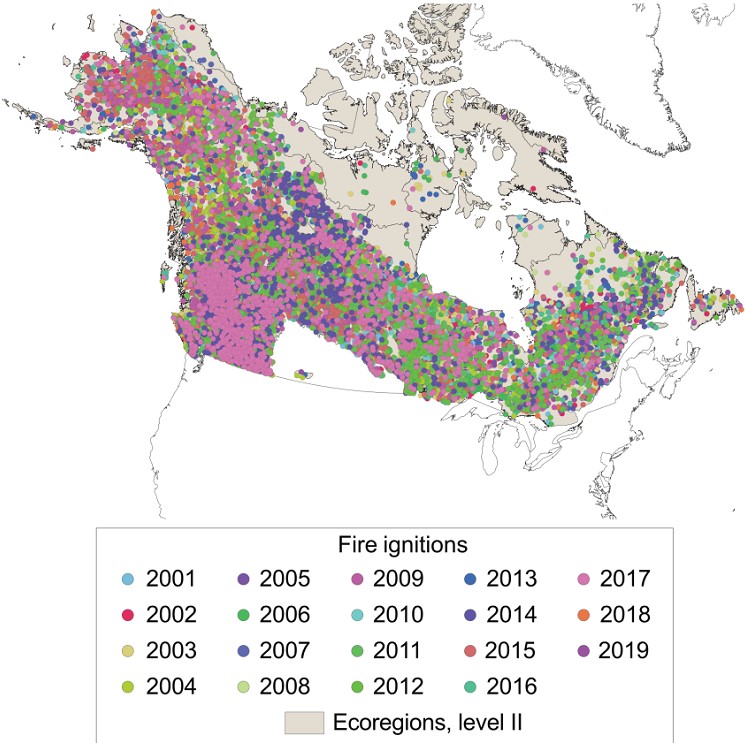
ABoVE: Ignitions of ABoVE-FED Fires in Alaska and Canada recent views
This dataset provides daily fire ignition locations and timing for boreal fires in Alaska, U.S., and Canada between 2001 and 2019. The fire ignition locations and timing are... -
Understory Vegetation Biomass from Selected Burned and Unburned sites in Alaska recent views
This dataset provides measurements of vegetation biomass from 11 locations across Alaska during 2016 to 2018. Vegetation was harvested from plots that were located at the end of... -
Understory Vegetation Biomass from Selected Burned and Unburned sites in Alaska recent views
This dataset provides measurements of vegetation biomass from 11 locations across Alaska during 2016 to 2018. Vegetation was harvested from plots that were located at the end of... -
Longwave-infrared spectral imagery in support of COMEX, 2014 recent views
This dataset provides calibrated at-sensor radiance, retrieved surface brightness temperature, and adaptive coherence estimator (ACE) detection imagery of methane, and a limited... -
LBA-ECO LC-01 City, Community, and Road Maps, Northern Ecuadorian Amazon: 1990-2002 recent views
This data set contains the boundaries of the four major cities in the Northern Ecuadorian Amazon, the locations of primary communities in the colonist settlement area, and the... -
LBA-ECO LC-09 Land Cover Transitions Maps for Study Sites in Para, Brazil: 1970-2001 recent views
This data set includes classified land cover transition maps at 30-m resolution derived from Landsat TM, MSS, ETM+ imagery and aerial photos of Altamira, Santarem, and Ponta de...

Official websites use .gov
A
.gov website belongs to an official government
organization in the United States.
Secure .gov websites use HTTPS
A
lock (
) or https:// means you’ve safely connected to
the .gov website. Share sensitive information only on official,
secure websites.