
-
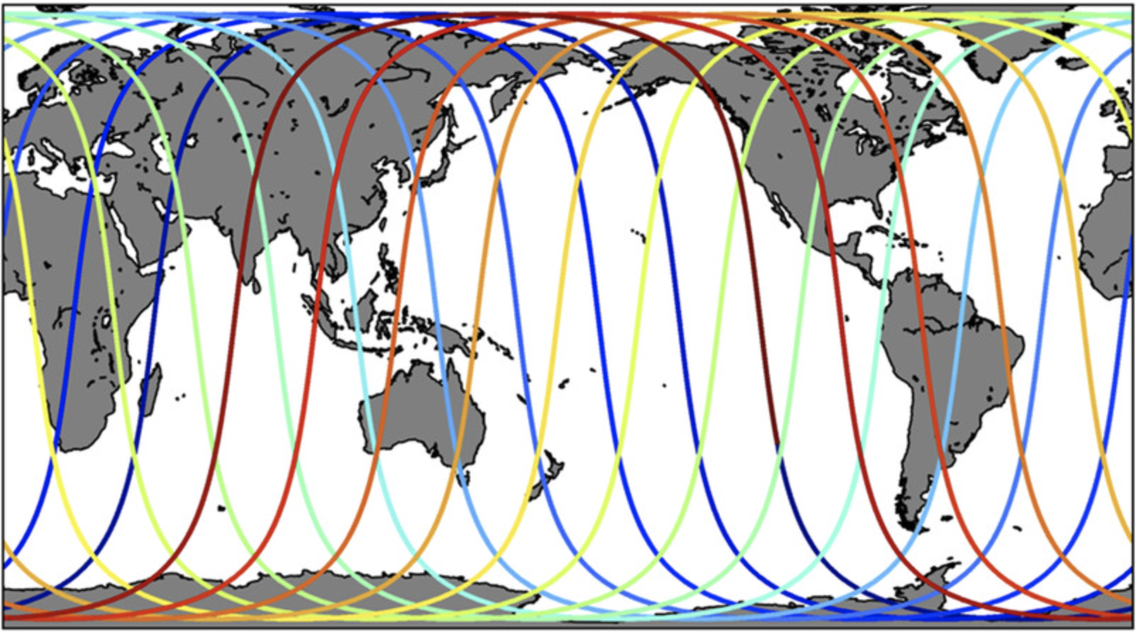
Sentinel-6A MF Jason-CS L1B GNSS-POD Tracking Data Hourly
Provides L1B hourly GNSS-POD tracking data for the Sentinel-6A radar altimetry mission. -
Labrador Sea Pre-SWOT Level-4 Hourly MITgcm LLC4320 Native Grid 2km Oceanographic Dataset Version 1.0
This dataset provides a regional multivariate oceanographic state estimate from a global ocean numerical simulation with a focus on the Labrador Sea region. The global ocean... -
SASSIE Arctic Field Campaign Shipboard uCTD Data Fall 2022 Version 1
The Salinity and Stratification at the Sea Ice Edge (SASSIE) project is a NASA experiment that aims to understand how salinity anomalies in the upper ocean generated by melting... -
SASSIE Arctic Field Campaign SWIFT Data Fall 2022 Version 1
The Salinity and Stratification at the Sea Ice Edge (SASSIE) project is a NASA experiment that aims to understand how salinity anomalies in the upper ocean generated by melting... -
S-MODE Shipboard uCTD and EcoCTD Measurements Version 1
This dataset contains shipboard Underway conductivity, temperature, and depth (UCDT) measurements taken during the Sub-Mesoscale Ocean Dynamics Experiment (S-MODE) field... -
S-MODE L2 Shipboard Meteorological Data from Rawinsondes Version 1
This dataset contains atmospheric sounding measurements taken during the Sub-Mesoscale Ocean Dynamics Experiment (S-MODE) field campaign. The experiment was conducted... -
S-MODE Lagrangian Float Observations Version 1
This dataset contains in-situ measurements of temperature, salinity, and velocity from the Sub-Mesoscale Ocean Dynamics Experiment (S-MODE) conducted approximately 300 km... -
S-MODE DopplerScatt Level 2 Ocean Winds and Currents Version 1
This dataset contains concurrent airborne DopplerScatt radar retrievals of surface vector winds and ocean currents from the Sub-Mesoscale Ocean Dynamics Experiment (S-MODE)... -
S-MODE Pre-Pilot Level 1 Data from the Ka-band Ocean Doppler Scatterometer (KaBODS) at the Air-Sea Interaction Tower Version 1
This data set includes tower-based Ka-band ocean surface backscatter measurements (cross section, incidence angle, radial velocity from radar, pulse-pair correlation) located... -
SWOT 2019-2020 Prelaunch Oceanography Field Campaign Rutgers Slocum Gliders
This dataset provides the Conductivity, Temperature, and Depth measurements carried by a Slocum glider. The measurements were collected during the 2019-2020 SWOT prelaunch field... -
SWOT 2019-2020 Prelaunch Oceanography Field Campaign NOAA Prawlers
This dataset provides the conductivity, temperature and depth (CTD) profiles from a Prawler profiler mooring deployed by the SWOT prelaunch field campaign. The campaign was... -
Sentinel-6A MF Jason-CS L3 P4 Altimeter High Resolution (HR) NTC Ocean Surface Topography (Unfiltered) Version F08
Provides L3 high resolution (HR) non-time critical (NTC; 60-day latency) altimetry from the Poseidon-4 SAR altimeter on the Sentinel-6A Michael Freilich spacecraft, which... -
SMODE L4 ROMS Model Ancillary Files Version 1
This dataset provides ancillary data for the Sub-Mesoscale Ocean Dynamics Experiment (S-MODE) Regional Ocean Modelling System (ROMS) model runs, and is intended for expert... -
GHRSST Level 4 REMO_OI_SST_5km Regional Foundation Sea Surface Temperature Analysis (GDS version 2)
A Group for High Resolution Sea Surface Temperature (GHRSST) Level 4 sea surface temperature (SST) analysis produced daily on an operational basis by the Oceanographic Modeling... -
ECCO Sea-Ice Velocity - Daily Mean llc90 Grid (Version 4 Release 4)
This dataset provides daily-averaged sea-ice velocity on the native Lat-Lon-Cap 90 (LLC90) model grid from the ECCO Version 4 Release 4 (V4r4) ocean and sea-ice state estimate.... -
ECCO Sea Surface Height - Daily Mean 0.5 Degree (Version 4 Release 4b)
This dataset contains daily-averaged dynamic sea surface height interpolated to a regular 0.5-degree grid from the ECCO Version 4 revision 4b (V4r4b) ocean and sea-ice state... -
ECCO Ocean Density, Stratification, and Hydrostatic Pressure - Daily Mean llc90 Grid (Version 4 Release 4)
This dataset provides daily-averaged ocean density, stratification, and hydrostatic pressure on the native Lat-Lon-Cap 90 (LLC90) model grid from the ECCO Version 4 Release 4... -
ECCO Gent-McWilliams Bolus Transport Streamfunction - Monthly Mean llc90 Grid (Version 4 Release 4)
This dataset provides monthly-averaged Gent-McWilliams ocean bolus transport streamfunction on the native Lat-Lon-Cap 90 (LLC90) model grid from the ECCO Version 4 Release 4... -
S-MODE L2 Position Data from Surface Drifters Version 1
This dataset contains in-situ position data from surface drifters from the Sub-Mesoscale Ocean Dynamics Experiment (S-MODE) conducted approximately 300 km offshore of San...

Official websites use .gov
A
.gov website belongs to an official government
organization in the United States.
Secure .gov websites use HTTPS
A
lock (
) or https:// means you’ve safely connected to
the .gov website. Share sensitive information only on official,
secure websites.