
-
Airborne Multi-angle Imaging SpectroRadiometer (AirMISR) Data from the Snow and Ice 2001 Campaign recent views
The AIRMISR_SNOW_ICE_2001 data were acquired during the Colorado snow albedo field experiment in the Yampa Valley of Colorado during February and March, 2001. This experiment... -
MISR Level 3 Component Global Aerosol Regional public Product covering a month V002 recent views
MI3MAER_2 is the Multi-angle Imaging SpectroRadiometer (MISR) Level 3 Component Global Aerosol Regional public Product covering a month version 2. It contains a monthly... -
MISR Level 3 Cloud Fraction by Altitude Product covering a month V001 recent views
MIL3MCFA_1 is the Multi-angle Imaging SpectroRadiometer (MISR) Level 3 Cloud Fraction by Altitude Product covering a month version 1. It provides the frequency of cloud... -
MISR Level 3 Global Joint Aerosol monthly product V002 recent views
MIL3MJTA_2 is the Multi-angle Imaging SpectroRadiometer (MISR) Level 3 Global Joint Aerosol monthly product version 2 data product. It contains global statistical summaries of... -
Soil Organic Carbon Stock Estimates with Uncertainty across Latin America recent views
This dataset provides 5 x 5 km gridded estimates of soil organic carbon (SOC) across Latin America that were derived from existing point soil characterization data and compiled... -
MISR Level 3 Component Global Aerosol Product covering a day V004 recent views
MIL3DAE_4 is the Multi-angle Imaging SpectroRadiometer (MISR) Level 3 Component Global Aerosol Product covering a day version 4. It contains a statistical summary of column... -
ABoVE: Lake and Wetland Classification from L-band SAR, Alaska and Canada, 2017-2019 recent views
This dataset contains a high-resolution land cover classification focused on water and wetland vegetation classes over three NASA ABoVE Campaign regions: Yukon Flats, Alaska,... -
GRIP HURRICANE IMAGING RADIOMETER (HIRAD) V1 recent views
The GRIP Hurricane Imaging Radiometer (HIRAD) V1 dataset contains measurements of brightness temperature taken at 4, 5, 6 and 6.6 GHz, as well as MERRA 2 m wind speed data and... -
Gazetteer of Planetary Nomenclature recent views
Planetary nomenclature, like terrestrial nomenclature, is used to uniquely identify a feature on the surface of a planet or satellite so that the feature can be easily located,... -
LiDAR and DTM Data from Tapajos National Forest in Para, Brazil, 2008 recent views
This data set provides LiDAR point clouds and digital terrain models (DTM) from surveys over the Tapajos National Forest in Belterra municipality, Para, Brazil during late June... -
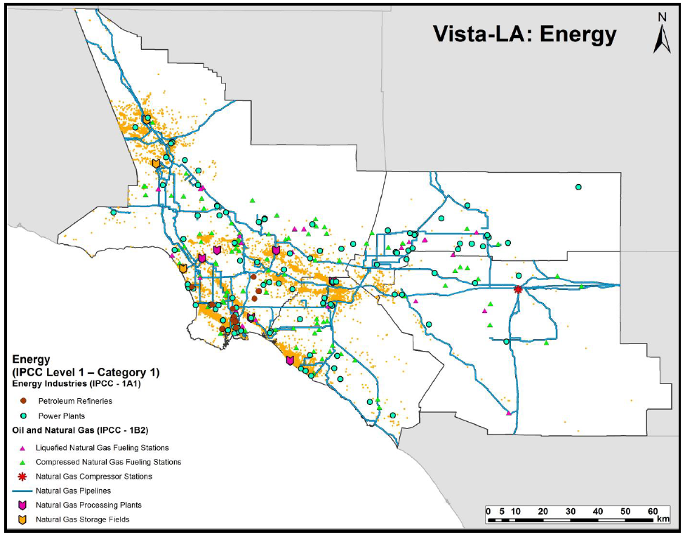
Sources of Methane Emissions (Vista-LA), South Coast Air Basin, California, USA recent views
This data set provides spatial data products with identified and classified locations of potential methane (CH4) emitting facilities and infrastructure in the South Coast Air... -
MISR Level 3 Global Cloud public Product in netCDF format covering a day V002 recent views
MI3DCLDN_2 is the Multi-angle Imaging SpectroRadiometer (MISR) Level 3 Global Cloud public Product in netCDF format covering a day version 2. It contains the public MISR Level 3... -
MISR Level 3 Cloud Motion Vector yearly Product in netCDF format V002 recent views
MI3YCMVN_2 is the Multi-angle Imaging SpectroRadiometer (MISR) Level 3 Cloud Motion Vector yearly Product in netCDF format version 2. It contains retrievals of cloud motion... -
MISR Level 3 Cloud Top Height-Optical Depth Product covering a year V001 recent views
MIL3YCOD_1 is the Multi-angle Imaging SpectroRadiometer (MISR) Level 3 Cloud Top Height-Optical Depth Product covering a year version 1. MISR itself is an instrument designed to... -
Airborne Multi-angle Imaging SpectroRadiometer (AirMISR) Data from the Morgan Monore 2003 Campaign recent views
The AIRMISR_MORGAN_MONROE_2003 data were acquired during a flight over the Morgan Monroe State Forest, Indiana, USA, target as part of the AirMISR deployments from the Wallops... -
Airborne Multi-angle Imaging SpectroRadiometer (AirMISR) Data from the Wisconsin 2000 Campaign recent views
The AIRMISR_WISCONSIN_2000 data were acquired during a field mission which overflew Wisconsin and the ARM/CART site in Oklahoma on March 3, 2000. The Jet Propulsion Laboratory... -
Airborne Multi-angle Imaging SpectroRadiometer (AirMISR) Data from the Harvard 2003 Campaign recent views
The AIRMISR_HARVARD_2003 data set was asquired during a flight over the Harvard Forest, Massachusetts, USA, target as part of the AirMISR deployments from the Wallops Flight... -
MISR Level 3 Component Global Land Regional public Product covering a day V002 recent views
MI3DLSR_2 is the Multi-angle Imaging SpectroRadiometer (MISR) Level 3 Component Global Land Regional public Product covering a dayversion 2. It contains a daily statistical... -
NARSTO EPA Supersite (SS) Houston, Texas Air Quality Study 2000 (TexAQS2000) Department of Energy (DOE) G-1 Air Chemistry, Aerosol, and Met Data recent views
NARSTO_EPA_SS_HOUSTON_TEXAQS2000_DOE_G-1_DATA is North American Research Strategy for Tropospheric Ozone (NARSTO) Environmental Protection Agency (EPA) Supersite (SS) Houston,...

Official websites use .gov
A
.gov website belongs to an official government
organization in the United States.
Secure .gov websites use HTTPS
A
lock (
) or https:// means you’ve safely connected to
the .gov website. Share sensitive information only on official,
secure websites.