
-
CARVE: Alaskan Fire Emissions Database (AKFED), 2001-2013 NGDA recent views
This data set provides estimates of annual carbon emissions (kg carbon per square meter) from boreal fires at 450-m resolution for the state of Alaska between 2001 and 2013. To... -
HURRICANE AND SEVERE STORM SENTINEL (HS3) GLOBAL HAWK NAVIGATION V1 recent views
The Hurricane and Severe Storm Sentinel (HS3) Global Hawk Navigation dataset consists of the real-time navigation and housekeeping data that was acquired from various... -
LBA-ECO CD-05 Understory Fuel Stick Moisture, km 67 Site, Para, Brazil: 1998-2000 recent views
This data set contains moisture content measurements for fuel sticks located in the forest understory of the rainfall exclusion experimental site, Tapajos National Forest, Para,... -
HURRICANE AND SEVERE STORM SENTINEL (HS3) WORLD WIDE LIGHTNING LOCATION NETWORK (WWLLN) STORMS V1 recent views
The World Wide Lightning Location Network (WWLLN) is a global, ground-based lightning sensor network operated by the University of Washington in Seattle. This network monitors... -
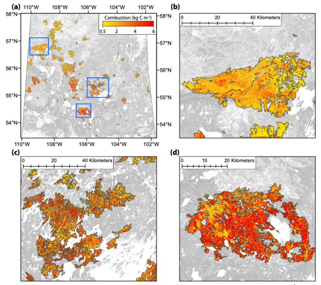
ABoVE: Spatial Estimates of Carbon Combustion from Wildfires across SK, Canada, 2015 recent views
This dataset provides spatial estimates of carbon combustion from all 2015 wildfire burned areas across Saskatchewan, Canada, on a 30-m grid. Carbon combustion (kg C/m2) was... -
Global Fire Atlas with Characteristics of Individual Fires, 2003-2016 NGDA recent views
The Global Fire Atlas is a global dataset that tracks the day-to-day dynamics of individual fires to determine the timing and location of ignitions, fire size, duration, daily... -
VIIRS/NPP Burned Area Monthly L4 Global 500m SIN Grid V001 recent views
The daily NASA/NOAA Suomi National Polar-orbiting Partnership (Suomi NPP) Visible Infrared Imaging Radiometer Suite (VIIRS) Burned Area (VNP64A1) Version 1 data product is a... -
ABoVE: AVHRR-Derived Forest Fire Burned Area-Hot Spots, Alaska and Canada, 1989-2000 recent views
This dataset provides annual forest fire burned area and daily hotspot products developed using data acquired from the Advanced Very-High-Resolution Radiometer (AVHRR)... -
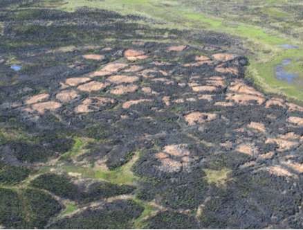
ABoVE: Post-Fire and Unburned Field Site Data, Anaktuvuk River Fire Area, 2008-2017 recent views
This dataset includes field measurements from 26 burned and unburned transects established in 2008 in the region of the Anaktuvuk River tundra fire on the Arctic Slope of... -
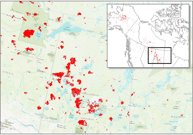
ABoVE: Wildfire Date of Burning within Fire Scars across Alaska and Canada, 2001-2019 NGDA recent views
This dataset provides estimates of wildfire progression represented by date of burning (DoB) within fire scars across Alaska and Canada for the period 2001-2019. Burn scar... -
Understory Vegetation Biomass from Selected Burned and Unburned sites in Alaska recent views
This dataset provides measurements of vegetation biomass from 11 locations across Alaska during 2016 to 2018. Vegetation was harvested from plots that were located at the end of... -
ABoVE: Landsat-derived Burn Scar dNBR across Alaska and Canada, 1985-2015 recent views
This dataset contains differenced Normalized Burned Ratio (dNBR) at 30-m resolution calculated for burn scars from fires that occurred within the Arctic Boreal and Vulnerability...

Official websites use .gov
A
.gov website belongs to an official government
organization in the United States.
Secure .gov websites use HTTPS
A
lock (
) or https:// means you’ve safely connected to
the .gov website. Share sensitive information only on official,
secure websites.