ABoVE: Spatial Estimates of Carbon Combustion from Wildfires across SK, Canada, 2015
Access & Use Information
Downloads & Resources
-
Google Scholar search resultsHTML
Search results for publications that cite this dataset by its DOI.
-
Download this datasetHTML
This link allows direct data access via Earthdata login
-
View documentation related to this datasetHTML
ORNL DAAC Data Set Documentation
-
This dataset's landing pageHTML
Data set Landing Page DOI URL
-
View documentation related to this datasetPDF
ABoVE: Spatial Estimates of Carbon Combustion from Wildfires across SK,...
-
Get a related visualizationPNG
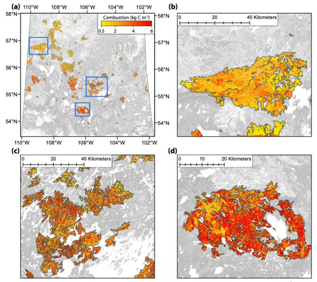
Spatial estimates of total carbon combustion at 30-m resolution across the...
-
The dataset's project home pageHTML
ABoVE project site
-
Landing PageLanding Page
Dates
| Metadata Created Date | December 1, 2022 |
|---|---|
| Metadata Updated Date | December 6, 2023 |
Metadata Source
- Data.json Data.json Metadata
Harvested from NASA Data.json
Graphic Preview

Additional Metadata
| Resource Type | Dataset |
|---|---|
| Metadata Created Date | December 1, 2022 |
| Metadata Updated Date | December 6, 2023 |
| Publisher | ORNL_DAAC |
| Maintainer | |
| Identifier | C2143401918-ORNL_CLOUD |
| Data First Published | 2020-07-15 |
| Language | en-US |
| Data Last Modified | 2023-06-12 |
| Category | ABoVE, geospatial |
| Public Access Level | public |
| Bureau Code | 026:00 |
| Metadata Context | https://project-open-data.cio.gov/v1.1/schema/catalog.jsonld |
| Metadata Catalog ID | https://data.nasa.gov/data.json |
| Schema Version | https://project-open-data.cio.gov/v1.1/schema |
| Catalog Describedby | https://project-open-data.cio.gov/v1.1/schema/catalog.json |
| Citation | Potter, S., B.M. Rogers, and C. Dieleman. 2020. ABoVE: Spatial Estimates of Carbon Combustion from Wildfires across SK, Canada, 2015. ORNL DAAC, Oak Ridge, Tennessee, USA. https://doi.org/10.3334/ORNLDAAC/1787 |
| Graphic Preview Description | Spatial estimates of total carbon combustion at 30-m resolution across the 2015 fire perimeters in Saskatchewan (a) and sampled fires (b, c, d). The spatial extents of sampled fires are shown as blue rectangles in (a). Source: Dieleman et al., 2020 |
| Graphic Preview File | https://daac.ornl.gov/ABOVE/guides/Post_Fire_C_Emissions_Fig1.png |
| Harvest Object Id | 7cdde9c6-f18f-42db-a8e4-0fc2c75c9e8d |
| Harvest Source Id | 58f92550-7a01-4f00-b1b2-8dc953bd598f |
| Harvest Source Title | NASA Data.json |
| Homepage URL | https://doi.org/10.3334/ORNLDAAC/1787 |
| Metadata Type | geospatial |
| Old Spatial | -116.06 51.19 -100.17 61.24 |
| Program Code | 026:001 |
| Source Datajson Identifier | True |
| Source Hash | 8b411ccaa818f4d8f075124efd758ff1da81443f481d866e17b67ff43bb36d93 |
| Source Schema Version | 1.1 |
| Spatial | |
| Temporal | 2015-04-06T00:00:00Z/2015-08-11T23:59:59Z |
Didn't find what you're looking for? Suggest a dataset here.

