
-
Geostationary Lightning Mapper (GLM) Thunder Hour Data Product
The Geostationary Lightning Mapper (GLM) is the first optical lightning detector in geostationary orbit, and GLM sensors operate aboard the National Oceanic and Atmospheric... -
REGIONAL AIR-SEA INTERACTION (RASI) GAP WIND AND COASTAL UPWELLING EVENTS CLIMATOLOGY GULF OF PANAMA, PANAMA V1
The Regional Air-Sea Interactions (RASI) Gap Wind and Coastal Upwelling Events Climatology Gulf of Panama, Panama dataset was created using an automated intelligent algorithm... -
GRIP HURRICANE IMAGING RADIOMETER (HIRAD) V1
The GRIP Hurricane Imaging Radiometer (HIRAD) V1 dataset contains measurements of brightness temperature taken at 4, 5, 6 and 6.6 GHz, as well as MERRA 2 m wind speed data and... -
AMPR BRIGHTNESS TEMPERATURE CAMEX-1 V2
The Advanced Microwave Precipitation Radiometer (AMPR) was deployed during the Convection and Moisture Experiments (CAMEX-1) conducted at Wallops Island, VA. AMPR data were... -
Flight Reports EPOCH
The Flight Reports EPOCH dataset consists of flight number, purpose of flight, and flight hours logged during the East Pacific Origins and Characteristics of Hurricanes (EPOCH)... -
GPM GROUND VALIDATION NOAA CPC MORPHING TECHNIQUE (CMORPH) IPHEX V1
The GPM Ground Validation NOAA CPC Morphing Technique (CMORPH) IPHEx dataset consists of global precipitation analyses data produced by the NOAA Climate Prediction Center (CPC)... -
GPM Ground Validation Optical Disdrometer (ODM) LPVEx
The GPM Ground Validation Optical Disdrometer (ODM) LPVEx dataset consists of precipitation particle size distribution data collected by the Eigenbrodt Optical Disdrometer (ODM)... -
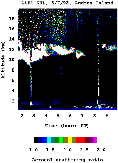
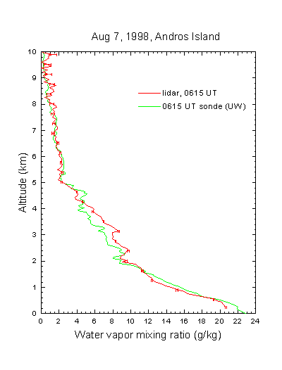
CAMEX-3 SCANNING RAMAN LIDAR V1
The CAMEX-3 Scanning Raman LIDAR dataset collected data during the CAMEX-3 campaign on Andros Island during the period 6 August - 20 September 1998. The SRL instrument is... -
Puerto Rico Radiosondes CPEX-AW V1
The Puerto Rico Radiosondes CPEX-AW dataset consists of atmospheric pressure, atmospheric temperature, relative humidity, wind speed, and wind direction measurements. These... -
GPM GROUND VALIDATION ACHIEVE W-BAND CLOUD RADAR IPHEX V1
The GPM Ground Validation ACHIEVE W-band Cloud Radar IPHEx dataset consists of cloud and light precipitation radar observations gathered during the Global Precipitation... -
RSS SSM/I OCEAN PRODUCT GRIDS MONTHLY AVERAGE FROM DMSP F15 NETCDF V7
The RSS SSM/I Ocean Product Grids Monthly Average from DMSP F15 netCDF dataset is part of the collection of Special Sensor Microwave/Imager (SSM/I) and Special Sensor Microwave... -
TCSP AMPR BRIGHTNESS TEMPERATURE (TB) V2
The TCSP AMPR Brightness Temperature (TB) dataset consists of brightness temperature measurements from July 5, 2005 to July 27, 2005. The Advanced Microwave Precipitation... -
GPM GROUND VALIDATION NASA MICRO RAIN RADAR (MRR) MC3E V1
The GPM Ground Validation NASA Micro Rain Radar (MRR) MC3E dataset was collected by a Micro Rain Radar (MRR), which is a vertically pointing Doppler radar which provides... -
Lightning Instrument Package (LIP) IMPACTS V2
The Lightning Instrument Package (LIP) IMPACTS dataset consists of electrical field measurements of lightning and navigation data collected by the Lightning Instrument Package... -
GPM Ground Validation Dual-frequency Dual-polarized Doppler Radar (D3R) OLYMPEX
The GPM Ground Validation Dual-frequency Dual-polarized Doppler Radar (D3R) OLYMPEX dataset contains radar reflectivity, velocity, differential reflectivity, differential phase,... -
CAMEX-4 MIPS FIELD MILL V1
The University of Alabama in Huntsville (UAH) Mobile Integrated Profiling System (MIPS) is a mobile atmospheric profiling system. It includes a 915 MHz Doppler profiler, lidar... -
GPM GROUND VALIDATION ENVIRONMENT CANADA (EC) MICRO RAIN RADAR (MRR) GCPEX
The GPM Ground Validation Environment Canada (EC) Micro Rain Radar (MRR) GCPEx V2 dataset was collected from the Micro Rain Radar (MRR) during the GPM Cold-season Precipitation... -
GRIP FLIGHT TRACKS AND ANIMATIONS V1
The GRIP Flight Tracks and Animations dataset includes both KML files and animation files. The KML files use Google Earth to show the flight tracks on a map. The animations vary... -
RSS SSM/I OCEAN PRODUCT GRIDS WEEKLY AVERAGE FROM DMSP F13 NETCDF V7
The RSS SSM/I Ocean Product Grids Weekly Average from DMSP F13 netCDF dataset is part of the collection of Special Sensor Microwave/Imager (SSM/I) and Special Sensor Microwave...

Official websites use .gov
A
.gov website belongs to an official government
organization in the United States.
Secure .gov websites use HTTPS
A
lock (
) or https:// means you’ve safely connected to
the .gov website. Share sensitive information only on official,
secure websites.