
-
Net Radiation and Albedo from MODIS for Xingu River Basin, Brazil, 2000-2012 NGDA recent views
This dataset provides daily average land surface net radiation (Rnet) as an 8-day time series at approximately 0.5 km resolution for the upper Xingu River Basin in Mato Grosso,... -
2015 Urban Extents from VIIRS and MODIS for the Continental U.S. Using Machine Learning Methods NGDA recent views
The 2015 Urban Extents from VIIRS and MODIS for the Continental U.S. Using Machine Learning Methods data set models urban settlements in the Continental United States (CONUS) as... -
Arctic Boreal Annual Burned Area, Circumpolar Boreal Forest and Tundra, V2, 2002-2022 NGDA recent views
This dataset provides annual cumulative end-of-season burned area in circumpolar boreal forests and tundra for the years 2002-2022. The data were generated using the Arctic... -
Urban Biogenic CO2 fluxes: GPP, Reco and NEE Estimates from SMUrF, 2010-2019 NGDA recent views
This dataset contains estimates of biogenic CO2 flux components at 0.05 degree resolution from the Solar-Induced Fluorescence (SIF) for Modeling Urban biogenic Fluxes (SMUrF)... -
ABoVE: Burned Area, Depth, and Combustion for Alaska and Canada, 2001-2019 NGDA recent views
This dataset provides annual gridded estimates of fire locations and associated burn fraction per pixel for Alaska and Canada at approximately 500 m spatial resolution for the... -
CARVE: Alaskan Fire Emissions Database (AKFED), 2001-2013 NGDA recent views
This data set provides estimates of annual carbon emissions (kg carbon per square meter) from boreal fires at 450-m resolution for the state of Alaska between 2001 and 2013. To... -
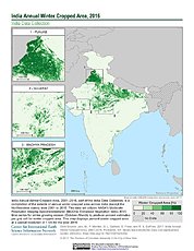
India Annual Winter Cropped Area, 2001-2016 NGDA recent views
The India Annual Winter Cropped Area, 2001 - 2016 consists of annual winter cropped areas for most of India (except the Northeastern states) from 2000-2001 to 2015-2016. This... -
Global Fire Atlas with Characteristics of Individual Fires, 2003-2016 NGDA recent views
The Global Fire Atlas is a global dataset that tracks the day-to-day dynamics of individual fires to determine the timing and location of ignitions, fire size, duration, daily... -
ABoVE: Wildfire Date of Burning within Fire Scars across Alaska and Canada, 2001-2019 NGDA recent views
This dataset provides estimates of wildfire progression represented by date of burning (DoB) within fire scars across Alaska and Canada for the period 2001-2019. Burn scar... -
ISLSCP II Global Population of the World NGDA recent views
Global Population of the World (GPW) translates census population data to a latitude-longitude grid so that population data may be used in cross-disciplinary studies. There are... -
LBA-ECO LC-39 MODIS Active Fire and Frequency Data for South America: 2000-2007 NGDA recent views
This data set provides active fire locations and estimates of annual fire frequencies for South America from 2000-2007. Data from the Moderate Resolution Imaging... -
ABoVE: Environmental Conditions During Fall Moose Hunting Seasons, Alaska, 2000-2016 NGDA recent views
This dataset provides daily and annual air temperature, river water level, and leaf drop dates coincident with the moose (Alces alces) hunting season (September) for the area... -
Fire Intensity and Burn Severity Metrics for Circumpolar Boreal Forests, 2001-2013 NGDA recent views
This data set provides products characterizing immediate and longer-term ecosystem changes from fires in the circumpolar boreal forests of Northern Eurasia and North America.... -
SAFARI 2000 1-Degree Estimates of Burned Biomass, Area, and Emissions, 2000 NGDA recent views
A new method is used to generate spatial estimates of monthly averaged biomass burned area and spatial and temporal estimates of trace gas and aerosol emissions from open fires... -
ISLSCP II Global Gridded Gross Domestic Product (GDP), 1990 NGDA recent views
The data sets in this directory were provided by Mr. Gregory Yetman and Drs. Stuart Gaffin and Deborah Balk from the Center for International Earth Science Information Network... -
SAFARI 2000 Emissions Estimates, MODIS Burned Area Product, Dry Season 2000 NGDA recent views
The recently generated MODIS burned area product over southern Africa for the month of September 2000 was used to calculate regional biomass burning emissions from grassland and... -
LBA-ECO LC-23 Characterization of Vegetation Fire Dynamics for Brazil: 2001-2003 NGDA recent views
Satellite fire detection was determined from two sensors, the Advanced Very High Resolution Radiometer (AVHRR) on NOAA-12 and the Moderate Resolution Imaging Spectroradiometer... -
Distribution of Estimated Stand Age Across Siberian Larch Forests, 1989-2012 NGDA recent views
This data set provides mapped estimates of the stand age of young (less than 25 years old) larch forests across Siberia from 1989-2012 at 30-m resolution. The age estimates were...

Official websites use .gov
A
.gov website belongs to an official government
organization in the United States.
Secure .gov websites use HTTPS
A
lock (
) or https:// means you’ve safely connected to
the .gov website. Share sensitive information only on official,
secure websites.