
-
ABoVE: Environmental Conditions and Subsistence Resource Access, Alaska, 2016-2017
This dataset provides descriptions and photos of environmental conditions that impacted availability to subsistence resources by residents in nine rural communities within the... -
Alaska's Changing YK Delta: Knowledge Exchange between Elders and Geoscientists, 2018
This dataset provides a booklet documenting the discussions and outcomes from a knowledge-exchange meeting with Yup'ik elders from the Yukon-Kuskokwim Delta (YKD), western... -
Compendium of Environmental Sustainability Indicator Collections: 2004 Environmental Vulnerability Index (EVI)
The 2004 Environmental Vulnerability Index (EVI) portion of the Compendium of Environmental Sustainability Indicator Collections contains 111 variables for 235 countries and... -
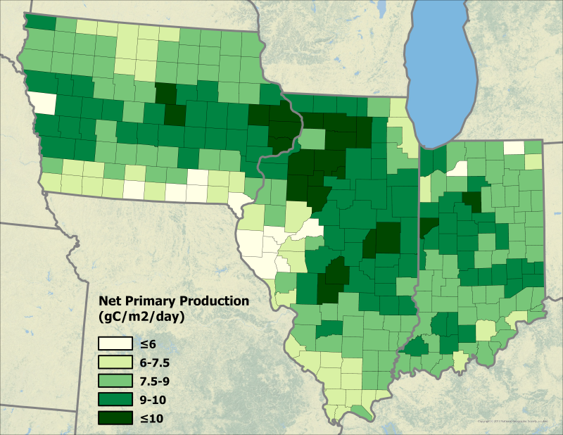
Export and Leaching of Carbon and Nitrogen from Mississippi River Basin, 1901-2099
This dataset provides estimates for export and leaching of dissolved inorganic carbon (DIC), dissolved organic carbon (DOC), total organic carbon (TOC), particulate organic... -
TOMS/N7 MS SO2 Vertical Column 1-Orbit L2 Swath 50x50 km V3 (TOMSN7SO2) at GES DISC
Version 3 is the current version of the data set. Older versions will no longer be available and have been superseded by Version 3. The goal of this data set is to create and... -
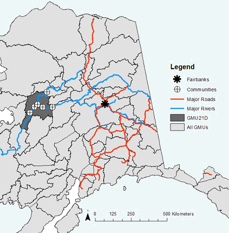
ABoVE: Environmental Conditions During Fall Moose Hunting Seasons, Alaska, 2000-2016 NGDA
This dataset provides daily and annual air temperature, river water level, and leaf drop dates coincident with the moose (Alces alces) hunting season (September) for the area... -
Geoecology: County-Level Environmental Data for the United States, 1941-1981
The Geoecology database is a compilation of environmental data for the period 1941 to 1981. The Geoecology database contains selected data on terrain and soils, water resources,... -
Committee on Earth Observation Satellites (CEOS) International Directory Portal
The CEOS IDN is an international effort developed to assist researchers in locating information on available datasets and services. The directory is sponsored as a service to... -
USGS JECAM Canada South Nation
Joint Experiment for Crop Assessment and Monitoring The overarching goal of JECAM is to reach a convergence of approaches, develop monitoring and reporting protocols and best... -
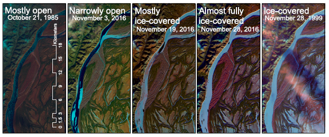
ABoVE: River Ice Breakup and Freeze-up Stages, Yukon River Basin, Alaska, 1972-2016
This dataset provides estimates of river ice breakup and freeze-up stages along selected reaches of the Yukon and Tanana Rivers in the Yukon River Basin in interior Alaska from... -
ACCLIP WB-57 Aircraft Merge Data
ACCLIP_Merge_WB57-Aircraft_Data is the pre-generated merge files created from a variety of in-situ instrumentation collecting measurements onboard the WB-57 aircraft during the... -
Annual wildland fire emissions (WFEIS v0.5) for Conterminous US and Alaska, 2001-2013 NGDA
This data set contains annual modeled estimates of wildland fire emissions at 0.01 degree (~1-km) spatial resolution from the Wildland Fire Emissions Information System (WFEIS... -
Voices from the Frontlines of Changing Bering Sea, Version 1
The Bering Sea is home to over 70 Indigenous communities of the Iñupiat, Central Yup’ik, Cup’ik, St. Lawrence Island Yupik, Unangan, and Chukchi Peoples. In recent years, the... -
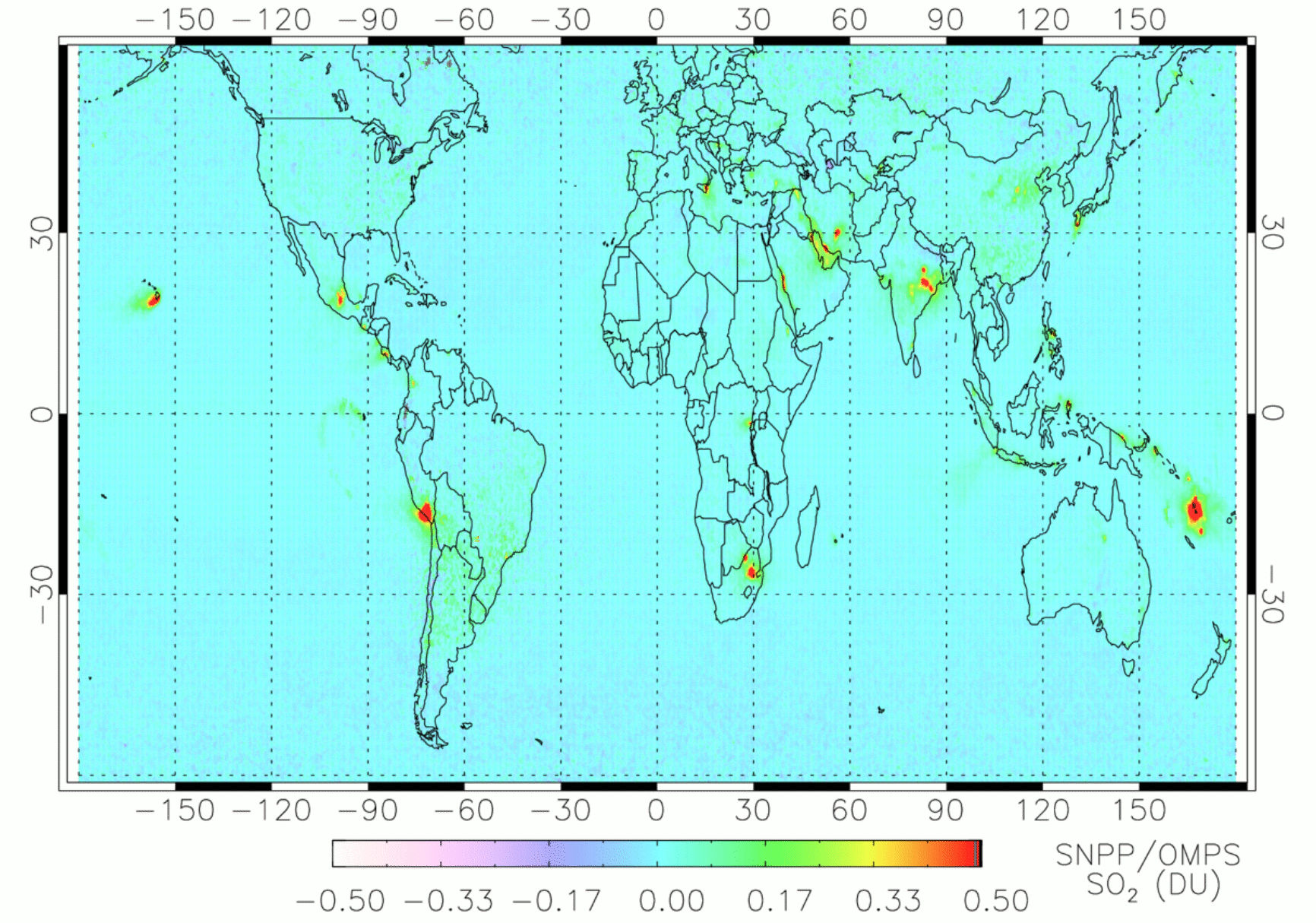
OMPS/NPP PCA SO2 Total Column 1-Orbit L2 Swath 50x50km V2 (OMPS_NPP_NMSO2_PCA_L2) at GES DISC
The OMPS_NPP_NMSO2_PCA_L2 product is part of the MEaSUREs (Making Earth Science Data Records for Use in Research Environments) suite of products. It is retrieved from the...

Official websites use .gov
A
.gov website belongs to an official government
organization in the United States.
Secure .gov websites use HTTPS
A
lock (
) or https:// means you’ve safely connected to
the .gov website. Share sensitive information only on official,
secure websites.