OMPS/NPP PCA SO2 Total Column 1-Orbit L2 Swath 50x50km V2 (OMPS_NPP_NMSO2_PCA_L2) at GES DISC
Access & Use Information
Downloads & Resources
-
Google Scholar search resultsHTML
Search results for publications that cite this dataset by its DOI.
-
Get a related visualizationPNG
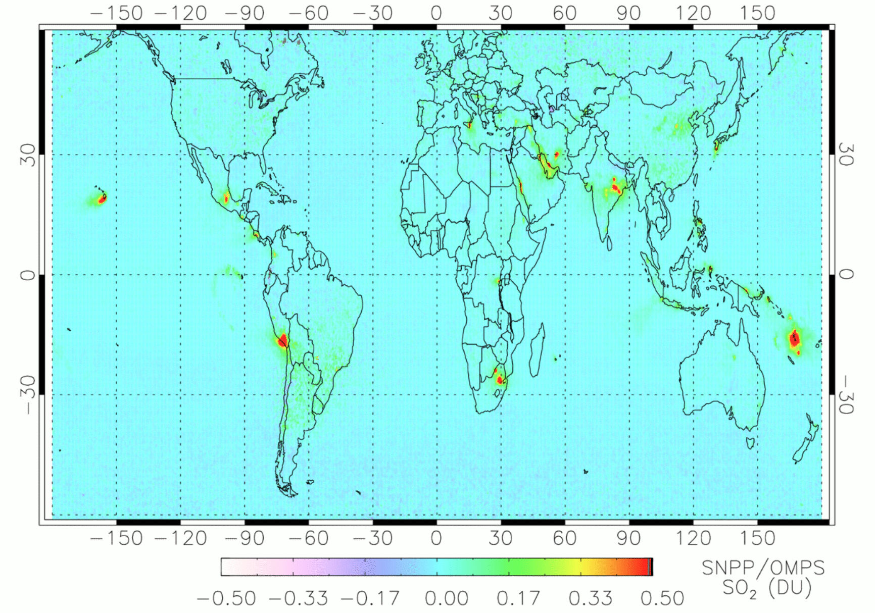
Annual mean SO2 vertical column densities (VCDs) in Dobson Units (DU, 1 DU =...
-
This dataset's landing pageHTML
Access the dataset landing page from the GES DISC website.
-
Download this dataset through a directory mapHTML
Access the data via HTTP
-
Use OPeNDAP to access the dataset's dataHTML
Access the data via the OPeNDAP protocol.
-
Download this dataset through Earthdata SearchHTML
Use the Earthdata Search to find and retrieve data sets across multiple data...
-
View the primary investigator's documentation...HTML
Global Sulfur Dioxide Monitoring Home Page
-
View this dataset's read me documentPDF
README document
-
Landing PageLanding Page
References
| https://doi.org/10.5194/amt-10-1495-2017 |
| https://doi.org/10.5194/amt-10-445-2017 |
| https://doi.org/10.1002/2013GL058134 |
| https://doi.org/10.5194/amt-2020-186 |
Dates
| Metadata Created Date | November 12, 2020 |
|---|---|
| Metadata Updated Date | December 6, 2023 |
Metadata Source
- Data.json Data.json Metadata
Harvested from NASA Data.json
Graphic Preview

Additional Metadata
| Resource Type | Dataset |
|---|---|
| Metadata Created Date | November 12, 2020 |
| Metadata Updated Date | December 6, 2023 |
| Publisher | NASA/GSFC/SED/ESD/GCDC/GESDISC |
| Maintainer | |
| Identifier | C1917909223-GES_DISC |
| Data First Published | 2020-07-29 |
| Language | en-US |
| Data Last Modified | 2020-07-29 |
| Category | MEaSUREs, geospatial |
| Public Access Level | public |
| Bureau Code | 026:00 |
| Metadata Context | https://project-open-data.cio.gov/v1.1/schema/catalog.jsonld |
| Metadata Catalog ID | https://data.nasa.gov/data.json |
| Schema Version | https://project-open-data.cio.gov/v1.1/schema |
| Catalog Describedby | https://project-open-data.cio.gov/v1.1/schema/catalog.json |
| Citation | Can Li, Nickolay A. Krotkov, Peter Leonard, Joanna Joiner. 2020-07-30. OMPS_NPP_NMSO2_PCA_L2. Version 2. OMPS/NPP PCA SO2 Total Column 1-Orbit L2 Swath 50x50km V2. Greenbelt, MD, USA. OMPS_NPP_NMSO2_PCA_L2. Archived by National Aeronautics and Space Administration, U.S. Government, Goddard Earth Sciences Data and Information Services Center (GES DISC). https://doi.org/10.5067/MEASURES/SO2/DATA205. https://disc.gsfc.nasa.gov/datacollection/OMPS_NPP_NMSO2_PCA_L2_2.html. Digital Science Data. |
| Creator | Can Li, Nickolay A. Krotkov, Peter Leonard, Joanna Joiner |
| Data Presentation Form | Digital Science Data |
| Graphic Preview Description | Annual mean SO2 vertical column densities (VCDs) in Dobson Units (DU, 1 DU = 2.69 ×10¹⁶ molecules/cm2) for 2018 from the OMPS_NPP_NMSO2_PCA_L2 V2.0 product. Pixels with large cloud fractions (> 0.3) or solar zenith angles (> 65º) or near the edge of the swath (rows 1-2 and 35-36 out of 36 OMPS rows) or low sensitivities to SO2 (air mass factor, AMF < 0.3) have been excluded. In addition, days with large volcanic plumes from explosive eruptions have also been excluded. Areas having major anthropogenic SO2 sources (e.g., India, eastern China, the Middle East, and South Africa) or degassing volcanoes (e.g., Kilauea and Etna) can be identified from the map. |
| Graphic Preview File | https://docserver.gesdisc.eosdis.nasa.gov/public/project/MEaSUREs/Krotkov/OMPS_NPP_NMSO2_PCA_L2.v2.png |
| Harvest Object Id | 70646dc9-0e53-403e-9553-2342297794c3 |
| Harvest Source Id | 58f92550-7a01-4f00-b1b2-8dc953bd598f |
| Harvest Source Title | NASA Data.json |
| Issue Identification | OMPS_NPP_NMSO2_PCA_L2 |
| Homepage URL | https://doi.org/10.5067/MEASURES/SO2/DATA205 |
| Metadata Type | geospatial |
| Old Spatial | -180.0 -90.0 180.0 90.0 |
| Program Code | 026:001 |
| Related Documents | https://doi.org/10.5194/amt-10-1495-2017, https://doi.org/10.5194/amt-10-445-2017, https://doi.org/10.1002/2013GL058134, https://doi.org/10.5194/amt-2020-186 |
| Release Place | Greenbelt, MD, USA |
| Series Name | OMPS_NPP_NMSO2_PCA_L2 |
| Source Datajson Identifier | True |
| Source Hash | 1995f163205f5058aa609bc8b66f8431b95fcd263d14ef98618ffd1902b59ebd |
| Source Schema Version | 1.1 |
| Spatial | |
| Temporal | 2012-01-26T21:52:00Z/2022-01-17T00:00:00Z |
Didn't find what you're looking for? Suggest a dataset here.

