
-
SWOT Level 2 Lake Single-Pass Vector Data Product, Version 2.0
The SWOT Level 2 Lake Single-Pass Vector Data Product from the Surface Water Ocean Topography (SWOT) mission provides water surface elevation, area, storage change derived from... -
GLDAS Noah Land Surface Model L4 monthly 0.25 x 0.25 degree V2.0 (GLDAS_NOAH025_M) at GES DISC
NASA Global Land Data Assimilation System Version 2 (GLDAS-2) has three components: GLDAS-2.0, GLDAS-2.1, and GLDAS-2.2. GLDAS-2.0 is forced entirely with the Princeton... -
CLPX-Model: Land Data Assimilation System (LDAS) Data, Version 1
The LDAS data set contains 43 model and observation-based fields produced by the LDAS uncoupled modeling system at the NASA Goddard Space Flight Center using the Mosaic Land... -
CLPX-Model: Rapid Update Cycle 40km (RUC-40) Model Output Reduced Data, Version 1
The Rapid Update Cycle, version 2 at 40km (RUC-2, known to the Cold Land Processes community as RUC40) model is a Mesoscale Analysis and Prediction System (MAPS) data set that... -
GLDAS Noah Land Surface Model L4 monthly 0.25 x 0.25 degree V2.1 (GLDAS_NOAH025_M) at GES DISC
NASA Global Land Data Assimilation System Version 2 (GLDAS-2) has three components: GLDAS-2.0, GLDAS-2.1, and GLDAS-2.2. GLDAS-2.0 is forced entirely with the Princeton... -
GLDAS VIC Land Surface Model L4 monthly 1.0 x 1.0 degree Early Product V2.1 (GLDAS_VIC10_M_EP) at GES DISC
NASA Global Land Data Assimilation System Version 2 (GLDAS-2) has three components: GLDAS-2.0, GLDAS-2.1, and GLDAS-2.2. GLDAS-2.0 is forced entirely with the Princeton... -
World Glacier Inventory, Version 1
The World Glacier Inventory (WGI) contains information for over 130,000 glaciers, or about 85% of the total estimated number of glaciers. Inventory parameters include geographic... -
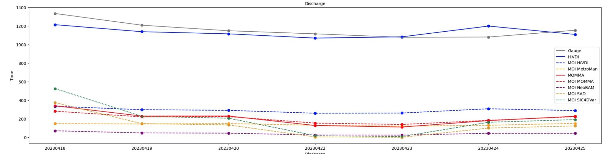
SWOT Sword of Science River Discharge Products Version 1
This dataset contains estimates of river discharge generated from hydrology observations taken by the Surface Water and Ocean Topography (SWOT) satellite. Data products are... -
Combined ASTER and MODIS Emissivity database over Land (CAMEL) Emissivity Monthly Global 0.05Deg V003 NGDA
The NASA Making Earth System Data Records for Use in Research Environments (MEaSUREs) (https://earthdata.nasa.gov/community/community-data-system-programs/measures-projects)... -
CLPX-Ground: ISA Snow Pit Measurements, Version 2
This data set consists of snow pit data from nine study areas, within three larger-scale areas in northern Colorado (Fraser, North Park, and Rabbit Ears Meso-cell Study Areas... -
Monthly Historical Water Balance Products for the CONUS
This dataset provides daily historical Water Balance Model outputs from a Thornthwaite-type, single bucket model. Climate inputs to the model are from GridMet daily temperature... -
GEWEX SRB Integrated Product (Rel-4) Ancillary 3-Hourly
GEWEX SRB Integrated Product (Rel-4) Ancillary 3-Hourly contains the global fields of meteorology, clouds and other ancillary data that serves as the inputs to the GEWEX SRB... -
Sea Ice in the Belcher Islands, Nunavut, Canada, Version 1
This data set contains interviews of three hunters from Sanikiliaq, Belcher Islands, in the territory of Nunavut, Canada. The hunters describe their observations of sea ice... -
FLDAS Noah Land Surface Model L4 Global Monthly 0.1 x 0.1 degree (MERRA-2 and CHIRPS) V001 (FLDAS_NOAH01_C_GL_M) at GES DISC
This dataset contains a series of land surface parameters simulated from the Noah 3.6.1 model in the Famine Early Warning Systems Network (FEWS NET) Land Data Assimilation... -
GLDAS Catchment Land Surface Model L4 daily 0.25 x 0.25 degree GRACE-DA1 V2.2 (GLDAS_CLSM025_DA1_D) at GES DISC
NASA Global Land Data Assimilation System Version 2 (GLDAS-2) has three components: GLDAS-2.0, GLDAS-2.1, and GLDAS-2.2. GLDAS-2.0 is forced entirely with the Princeton... -
USGS Digital Orthophoto Quadrangles
A Digital Orthophoto Quadrangle (DOQ) is a computer-generated image of an aerial photograph in which the image displacement caused by terrain relief and camera tilt has been...

Official websites use .gov
A
.gov website belongs to an official government
organization in the United States.
Secure .gov websites use HTTPS
A
lock (
) or https:// means you’ve safely connected to
the .gov website. Share sensitive information only on official,
secure websites.