
-
Global Change Master Directory (GCMD) recent views
The GCMD database holds more than 30,000 descriptions of Earth science data sets and services covering all aspects of Earth and environmental sciences. The mission of the GCMD... -
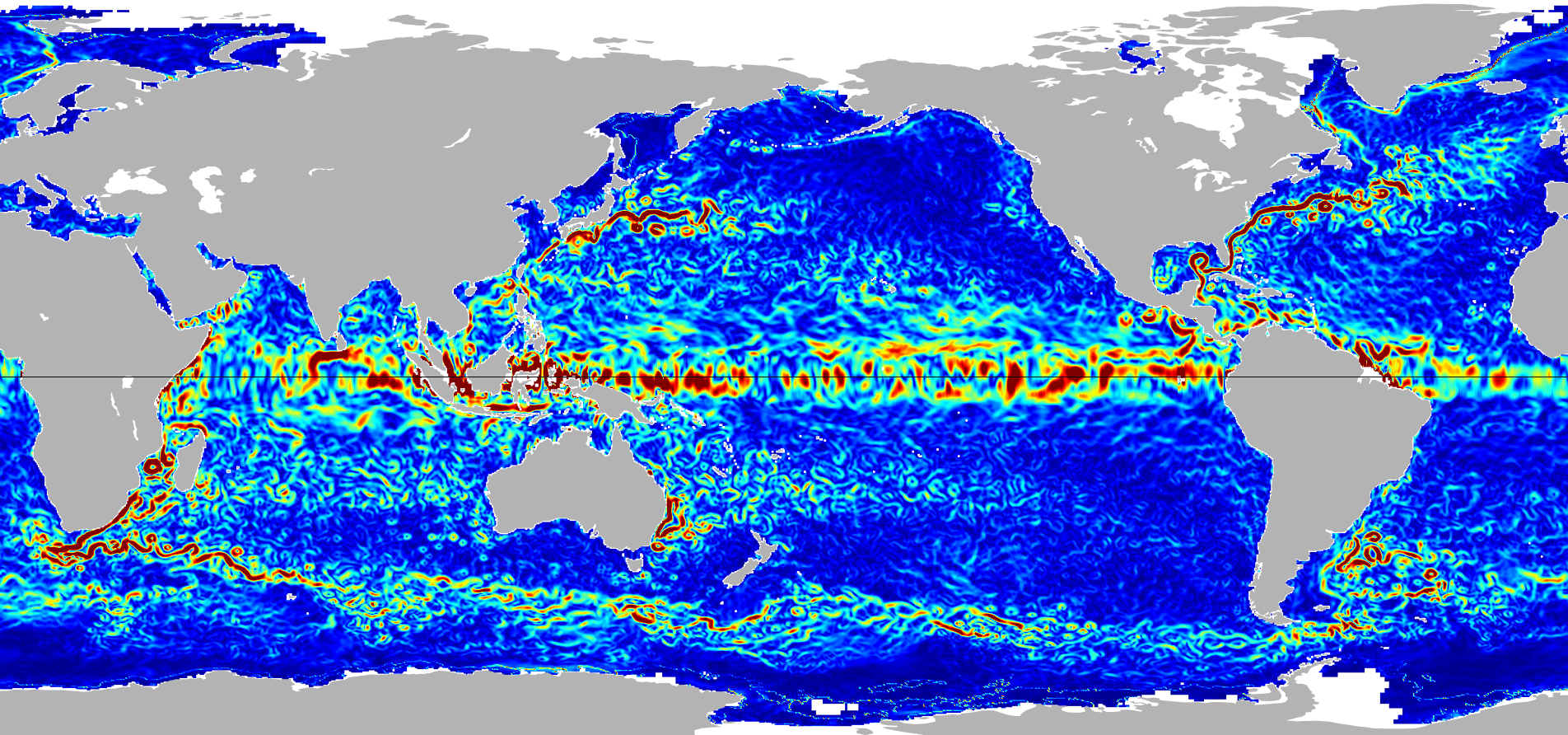
Ocean Surface Current Analyses Real-time (OSCAR) Surface Currents - Final 0.25 Degree (Version 2.0) recent views
Ocean Surface Current Analyses Real-time (OSCAR) is a global surface current database and NASA funded research project. OSCAR ocean mixed layer velocities are calculated from... -
National Oceanic and Atmospheric Administration (NOAA) recent views
NOAA measurements from 1996 to 1999 along the Eastern US coastal region. -
MERRA-2 tavg1_2d_slv_Nx: 2d,1-Hourly,Time-Averaged,Single-Level,Assimilation,Single-Level Diagnostics 0.625 x 0.5 degree V5.12.4 (M2T1NXSLV) at GES DISC recent views
M2T1NXSLV (or tavg1_2d_slv_Nx) is an hourly time-averaged 2-dimensional data collection in Modern-Era Retrospective analysis for Research and Applications version 2 (MERRA-2).... -
SRTM Water Body Data recent views
The SRTM Water Body Data files are a by-product of the data editing performed by the National Geospatial-Intelligence Agency (NGA) to produce the finished SRTM Digital Terrain... -
NOAA Fisheries Ecosystem Monitoring Program recent views
EcoMon is the NOAA Northeast Fisheries Science Center Ecosystem Monitoring program for the Northeast U.S. continental shelf. EcoMon main objective is hydrography and zooplankton... -
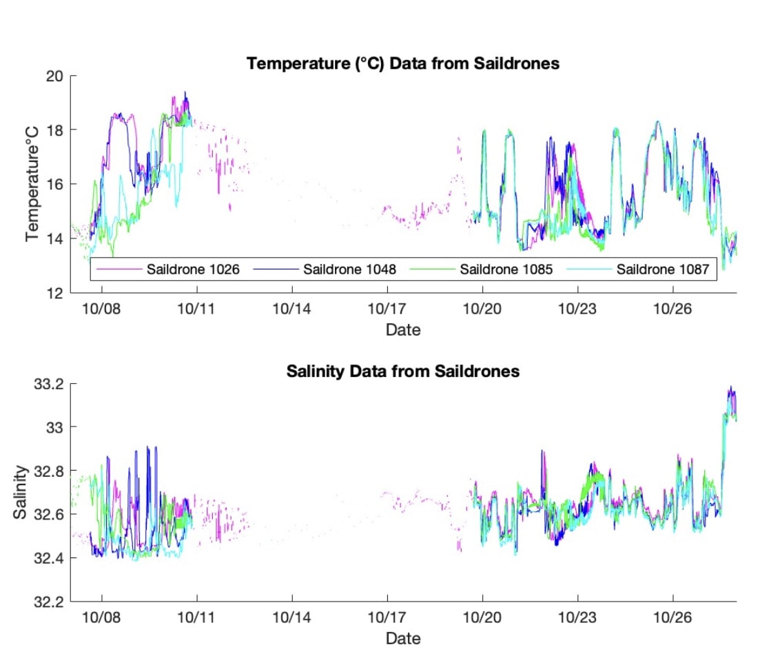
S-MODE L2 Temperature and Salinity from Saildrones Version 1 recent views
This dataset contains Saildrone in-situ measurements taken during the Sub-Mesoscale Ocean Dynamics Experiment (S-MODE) conducted approximately 300 km offshore of San Francisco... -
Enhancing Knowledge of the Arabian Sea Marine environment through Science and Advanced Training (EKAMSAT) recent views
Enhancing Knowledge of the Arabian Sea Marine environment through Science and Advanced Training (EKAMSAT) is a collaborative Indo-US field campaign funded by the Ministry of... -
Ocean Surface Current Analyses Real-time (OSCAR) Surface Currents - Near Real Time 0.25 Degree (Version 2.0) recent views
Ocean Surface Current Analyses Real-time (OSCAR) is a global surface current database and NASA funded research project. OSCAR ocean mixed layer velocities are calculated from... -
Panama City, Florida optical measurements in 1993 recent views
Measurements taken in the Gulf of Mexico near Panama City, Florida in 1993. -
Ocean color calibration and validation measurements off the New Jersey and New York coasts recent views
Measurements made off the New Jersey and New York coasts between 2005 and 2009. -
2011 R/V Catlin cruise in the Arctic Ocean recent views
Measurements made in the Arctic Ocean by the RV Catlin in 2011. -
VIIRS validation measurements made in the Florida Keys recent views
Measurements made in the Florida Keys as part of efforts to Validate the VIIRS instrument. -
CYGNSS Level 3 MRG Science Data Record Near Real Time Version 3.2.1 recent views
This dataset contains the version 3.2.1 CYGNSS Level 3 Merged (MRG) Science Data Record Near Real Time (NRT) Storm Wind Speed derived from the Delay Doppler Mapping Instrument... -
Jason-1 SGDR version E NetCDF recent views
The Sensory Geophysical Data Record (SGDR) files contain full accuracy altimeter data, with a high precision orbit (accuracy ~1.5 cm). The instruments on Jason-1 make direct... -
OSCAR third degree resolution ocean surface currents - yearly files recent views
OSCAR (Ocean Surface Current Analysis Real-time) contains near-surface ocean current estimates, derived using quasi-linear and steady flow momentum equations. The horizontal... -
Landsat Surface Reflectance - L8 OLI/TIRS recent views
Landsat satellite data have been produced, archived, and distributed by the U.S. Geological Survey (USGS) since 1972. Users rely on these data for historical study of land... -
NOAA-21 VIIRS Global Binned Particulate Inorganic Carbon (PIC) Data, version R2022.0 recent views
The Visible and Infrared Imager/Radiometer Suite (VIIRS) is a multi-disciplinary instrument that is being flown on the Joint Polar Satellite System (JPSS) series of spacecraft,... -
West Florida Shelf measurements between 2005 and 2008 recent views
Measurements made along the West Florida Shelf between 2005 and 2008. -
Penobscot Bay Optical Survey recent views
Measurements made in the Penobscot Bay between 2007 and 2008.

Official websites use .gov
A
.gov website belongs to an official government
organization in the United States.
Secure .gov websites use HTTPS
A
lock (
) or https:// means you’ve safely connected to
the .gov website. Share sensitive information only on official,
secure websites.