
-
CORONA Satellite Photography recent views
On February 24, 1995, President Clinton signed an Executive Order, directing the declassification of intelligence imagery acquired by the first generation of United States... -
National Agriculture Imagery Program (NAIP) recent views
The National Agriculture Imagery Program (NAIP) acquires aerial imagery during the agricultural growing seasons in the continental U.S. A primary goal of the NAIP program is to... -
Shuttle Radar Topography Mission DTED Level 1 (3-arc second) Data (DTED-1) recent views
The Shuttle Radar Topography Mission (SRTM) successfully collected Interferometric Synthetic Aperture Radar (IFSAR) data over 80 percent of the landmass of the Earth between 60... -
Landsat 8 recent views
The Operational Land Imager (OLI) and Thermal Infrared Sensor (TIRS) are onboard the Landsat 8 satellite, have acquired images of the Earth since February 2013. The sensors... -
GLDAS Noah Land Surface Model L4 monthly 0.25 x 0.25 degree V2.1 (GLDAS_NOAH025_M) at GES DISC recent views
NASA Global Land Data Assimilation System Version 2 (GLDAS-2) has three components: GLDAS-2.0, GLDAS-2.1, and GLDAS-2.2. GLDAS-2.0 is forced entirely with the Princeton... -
GPM IMERG Final Precipitation L3 Half Hourly 0.1 degree x 0.1 degree V07 (GPM_3IMERGHH) at GES DISC recent views
Version 07 is the current version of the data set. Older versions will no longer be available and have been superseded by Version 07. The Integrated Multi-satellitE Retrievals... -
India Village-Level Geospatial Socio-Economic Data Set: 1991, 2001 recent views
The India Village-Level Geospatial Socio-Economic Data Set: 1991, 2001 is a compilation of the finest level of administrative boundaries in India (village/town-level) and over... -
ASTER Global DEM NGDA recent views
ASTER is capable of collecting in-track stereo using nadir- and aft-looking near infrared cameras. Since 2001, these stereo pairs have been used to produce single-scene (60- x... -
Georeferenced Population Datasets of Mexico (GEO-MEX): Urban Place GIS Coverage of Mexico recent views
The Urban Place GIS Coverage of Mexico is a vector based point Geographic Information System (GIS) coverage of 696 urban places in Mexico. Each Urban Place is geographically... -
MERRA-2 inst3_3d_aer_Nv: 3d,3-Hourly,Instantaneous,Model-Level,Assimilation,Aerosol Mixing Ratio 0.625 x 0.5 degree V5.12.4 (M2I3NVAER) at GES DISC recent views
M2I3NVAER (or inst3_3d_aer_Nv) is an instantaneous 3-dimensional 3-hourly data collection in Modern-Era Retrospective analysis for Research and Applications version 2 (MERRA-2).... -
MERRA-2 tavg1_2d_slv_Nx: 2d,1-Hourly,Time-Averaged,Single-Level,Assimilation,Single-Level Diagnostics 0.625 x 0.5 degree V5.12.4 (M2T1NXSLV) at GES DISC recent views
M2T1NXSLV (or tavg1_2d_slv_Nx) is an hourly time-averaged 2-dimensional data collection in Modern-Era Retrospective analysis for Research and Applications version 2 (MERRA-2).... -
VEMAP 2: Annual Ecosystem Model Responses to U.S. Climate Change, 1994-2100 recent views
Phase 2 of the VEMAP Project developed historical (1895-1993) gridded data sets of climate (temperature, precipitation, solar radiation, humidity, and wind speed) and projected... -
TRMM (TMPA) Rainfall Estimate L3 3 hour 0.25 degree x 0.25 degree V7 (TRMM_3B42) at GES DISC recent views
TMPA (3B42) dataset have been discontinued as of Dec. 31, 2019, and users are strongly encouraged to shift to the successor IMERG dataset (doi: 10.5067/GPM/IMERG/3B-HH/06). This... -
GLDAS Catchment Land Surface Model L4 daily 0.25 x 0.25 degree V2.0 (GLDAS_CLSM025_D) at GES DISC recent views
NASA Global Land Data Assimilation System Version 2 (GLDAS-2) has three components: GLDAS-2.0, GLDAS-2.1, and GLDAS-2.2. GLDAS-2.0 is forced entirely with the Princeton... -
Mars surface image (Curiosity rover) labeled data set version 1 recent views
This data set consists of 6691 images spanning 24 classes that were collected by the Mars Science Laboratory (MSL, Curosity) rover by three instruments (Mastcam Right eye,... -
National Space Science Data Center Master Catalog recent views
The National Space Science Data Center serves as the permanent archive for NASA space science mission data. 'Space science' means astronomy and astrophysics, solar and space... -
Ocean Surface Current Analyses Real-time (OSCAR) Surface Currents - Final 0.25 Degree (Version 2.0) recent views
Ocean Surface Current Analyses Real-time (OSCAR) is a global surface current database and NASA funded research project. OSCAR ocean mixed layer velocities are calculated from... -
ASTER Global Digital Elevation Model V003 NGDA recent views
The ASTER Global Digital Elevation Model (GDEM) Version 3 (ASTGTM) provides a global digital elevation model (DEM) of land areas on Earth at a spatial resolution of 1 arc second... -
CALIPSO Lidar Level 2 Cloud Profile, V4-20 recent views
CAL_LID_L2_05kmCPro-Standard-V4-20 is the Cloud-Aerosol Lidar and Infrared Pathfinder Satellite Observations (CALIPSO) Lidar Level 2 Cloud Profile, Version 4-20 data product.... -
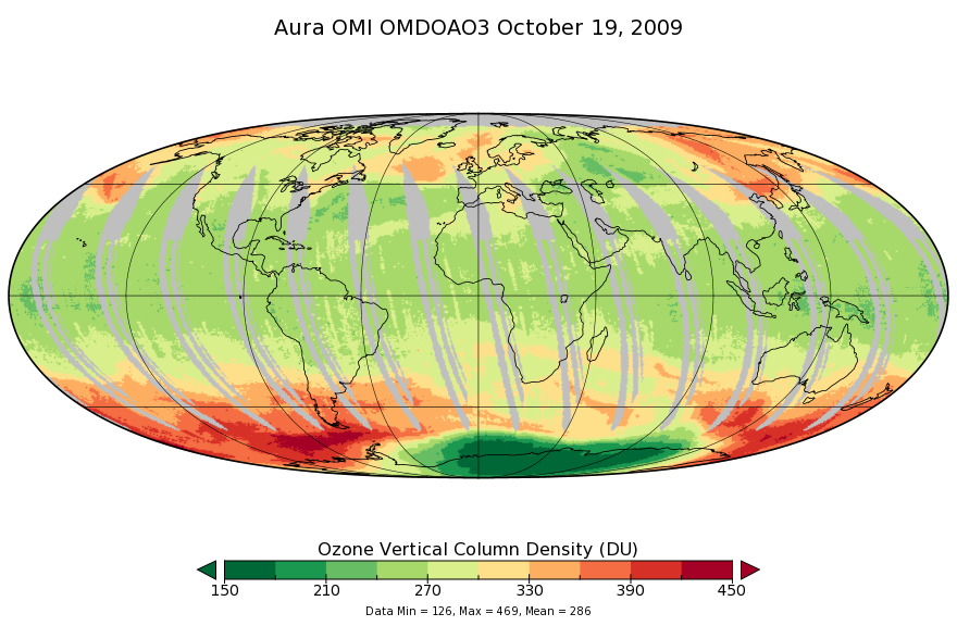
OMI/Aura Ozone (O3) DOAS Total Column Daily L3 1 day 0.25 degree x 0.25 degree V3 (OMDOAO3e) at GES DISC recent views
The OMI science team produces this Level-3 Aura/OMI Global OMDOAO3e Data Products (0.25deg Lat/Lon grids). This Level-3 global total column ozone product is derived from OMDOAO3...

Official websites use .gov
A
.gov website belongs to an official government
organization in the United States.
Secure .gov websites use HTTPS
A
lock (
) or https:// means you’ve safely connected to
the .gov website. Share sensitive information only on official,
secure websites.