
-
UARS Correlative NMC Daily Gridded Stratospheric Assimilated Data V001 (UARZCNMC) at GES DISC recent views
The UARS Correlative assimilation data from NOAA's National Meteorological Center (NMC) consists of daily model runs at 12 GMT as a means of providing an independent analysis... -
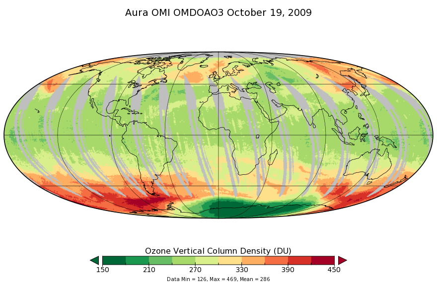
OMI/Aura Ozone (O3) DOAS Total Column Daily L3 1 day 0.25 degree x 0.25 degree V3 (OMDOAO3e) at GES DISC recent views
The OMI science team produces this Level-3 Aura/OMI Global OMDOAO3e Data Products (0.25deg Lat/Lon grids). This Level-3 global total column ozone product is derived from OMDOAO3... -
30 Minute Rainfall Data (FIFE) recent views
30 minute rainfall data for the Konza Prairie -
UARS Solar Ultraviolet Spectral Irradiance Monitor (SUSIM) Level 3BS V022 (UARSU3BS) at GES DISC recent views
The Solar Ultraviolet Spectral Irradiance Monitor (SUSIM) Level 3BS data product consists of daily, 1 nm resolution, solar spectral irradiances and selected solar parameters.... -
CAMEX-4 AEROSONDE V1 recent views
The CAMEX-4 Aerosonde dataset contains temperature, humidity, and atmospheric pressure measurements collected to study the boundary layer below levels where traditional... -
BOREAS TE-05 Leaf Carbon Isotope Data recent views
Contains leaf carbon isotope data collected by TE-05 during 1994. -
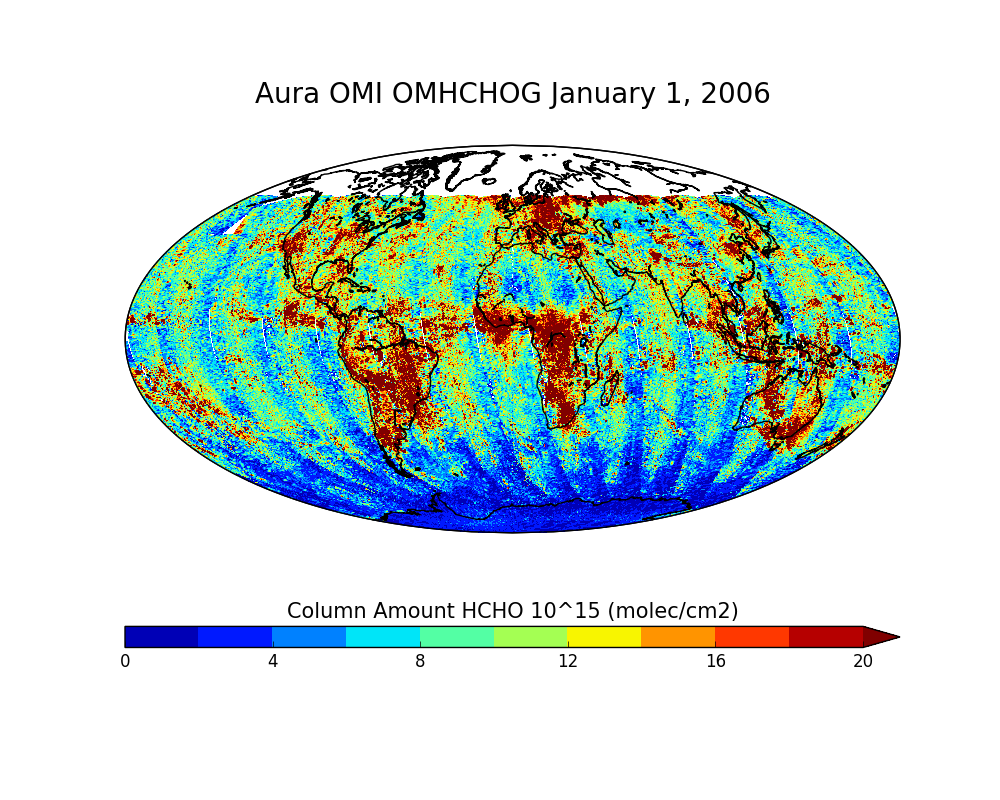
OMI/Aura Formaldehyde (HCHO) Total Column Daily L2 Global Gridded 0.25 degree x 0.25 degree V3 (OMHCHOG) at GES DISC recent views
This Level-2G daily global gridded product OMHCHOG is based on the pixel level OMI Level-2 HCHO product OMHCHO. OMHCHOG data product is a special Level-2 Global Gridded Product... -
BOREAS AFM-08 ECMWF Hourly Surface and Upper Air Data for the SSA and NSA recent views
Hourly data from the ECMWF operational model from below the surface to the top of the atmosphere, including the model fluxes at the surface, at Candle Lake, Saskatchewan, in the... -
BOREAS RSS-02 Extracted Reflectance Factors Derived from ASAS Imagery recent views
Contains calculated bidirectional reflectance factor means derived from extractions of C130-based ASAS measurements made during BOREAS. -
BOREAS Landsat TM Level-3s Imagery: Scaled At-Sensor Radiance in LGSOWG Format recent views
For BOREAS, the level-3s Landsat TM data, along with the other remotely sensed images, were collected in order to provide spatially extensive information over the primary study... -
BOREAS/SRC AMS Suite A Surface Meteorological and Radiation Data: 1996 recent views
Contains the data collected in 1996 by the AMS suite A instrument set operated by SRC and provided to BORIS. -
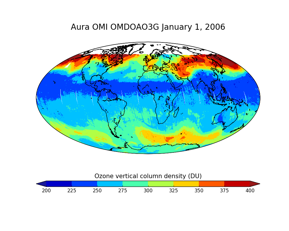
OMI/Aura Ozone (O3) DOAS Total Column Daily L2 Global Gridded 0.25 degree x 0.25 degree V3 (OMDOAO3G) at GES DISC recent views
This Level-2G daily global gridded product OMDOAO3G is based on the pixel level OMI Level-2 DOAO3 product OMDOAO3. This Level-2G global total column ozone product is derived... -
BOREAS Daedalus TMS Level-0 Imagery: Digital Counts in BIL Format recent views
The level-0 Daedalus TMS imagery, along with the other remotely sensed images, was collected to provide spatially extensive information about radiant energy over the primary... -
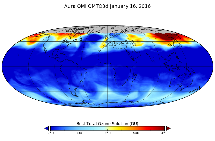
OMI/Aura TOMS-Like Ozone, Aerosol Index, Cloud Radiance Fraction L3 1 day 1 degree x 1 degree V3 (OMTO3d) at GES DISC recent views
The OMI science team produces this Level-3 daily global TOMS-Like Total Column Ozone gridded product OMTO3d (1 deg Lat/Lon grids). The OMTO3d product is produced by gridding and... -
OMI/Aura Multi-wavelength Aerosol Optical Depth and Single Scattering Albedo Daily L2 Global Gridded 0.25 degree x 0.25 degree V3 (OMAEROG) at GES DISC recent views
This Level-2G daily global gridded product OMAEROG is based on the pixel level OMI Level-2 Aerosol product OMAERO, based on the multi-wavelength algorithm that uses up to 20... -
BOREAS Site and Area Geographic Coordinate Information recent views
Geographic coordinate and other site information from several sources throughout the experiment period. The final set of information is organized into two data sets that provide... -
BOREAS TE-18 Landsat TM Maximum Likelihood Classification Image of the SSA recent views
A Landsat-5 TM image from 06-Aug-1990 was used to derive this classification, the objective of which is to provide BOREAS investigators with a data product that characterizes... -
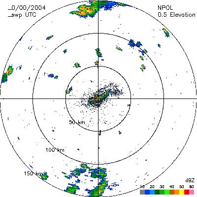
CAMEX-4 NASA PORTABLE S-BAND MULTIPARAMETER WX RESEARCH RADAR V1 recent views
The CAMEX-4 NASA Portable S-Band Multiparameter WX Research Radar dataset was collected by the NASA Portable S-band Multiparameter Weather Research Radar (NPOL), which is a... -
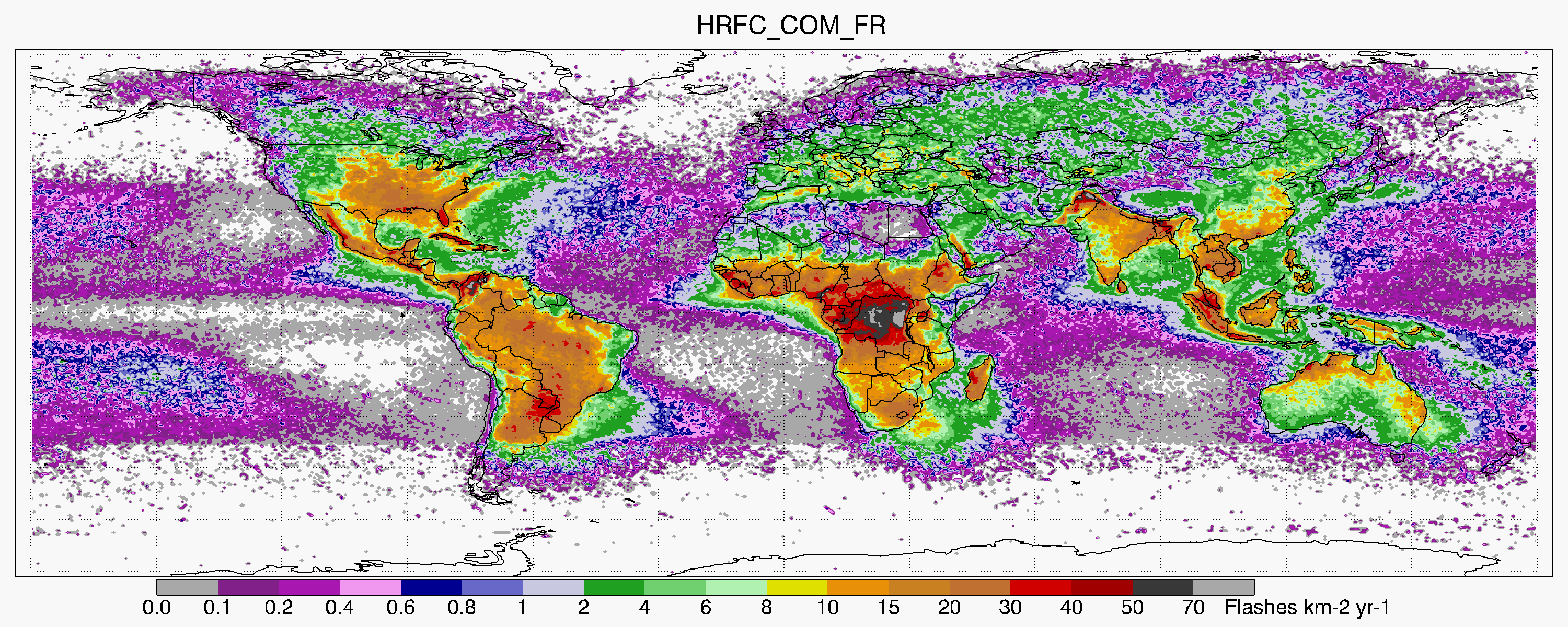
LIS/OTD 0.5 Degree High Resolution Full Climatology (HRFC) V2.3.2015 recent views
The LIS/OTD 0.5 Degree High Resolution Full Climatology (HRFC) contains a variety of gridded climatologies of total lightning flash rates obtained from two lightning detection...

Official websites use .gov
A
.gov website belongs to an official government
organization in the United States.
Secure .gov websites use HTTPS
A
lock (
) or https:// means you’ve safely connected to
the .gov website. Share sensitive information only on official,
secure websites.