
-
Global Fire Emissions Database, Version 4.1 (GFEDv4) NGDA recent views
This dataset provides global estimates of monthly burned area, monthly emissions and fractional contributions of different fire types, daily or 3-hourly fields to scale the... -
MODIS-derived Annual Vegetation Resilience, 2000-2019 NGDA recent views
This dataset provides estimates of vegetation resilience in the Arctic Boreal Vulnerability Experiment (ABoVE) core domain at annual time steps for 2000-2019 and at 300-m... -
ISLSCP II Ecosystem Rooting Depths NGDA recent views
The goal of this study was to predict the global distribution of plant rooting depths based on data about global aboveground vegetation structure and climate. Vertical root... -
MODIS-derived Vegetation and Albedo Parameters for Agroecosystem-Climate Modeling NGDA recent views
This dataset provides MODIS-derived leaf area index (LAI), stem area index (SAI), vegetation area fraction, dominant landcover category, and albedo parameters for the... -
ISLSCP II MODIS (Collection 4) Albedo, 2002 NGDA recent views
This International Satellite Land Surface Climatology Project (ISLSCP II) MODerate resolution Image Spectroradiometer (MODIS) dataset, ISLSCP II MODIS (Collection 4) Albedo... -
Ecosystem Functional Type Distribution Map for the Conterminous USA, 2001-2014 NGDA recent views
This dataset provides maps of the distribution of ecosystem functional types (EFTs) and the interannual variability of EFTs at 0.05 degree resolution across the conterminous... -
Global MODIS and FLUXNET-derived Daily Gross Primary Production, V2 NGDA recent views
This dataset provides global gridded daily estimates of gross primary production (GPP) and uncertainties at 0.05-degree resolution for the period 2000-03-01 to the recent past.... -
Global Monthly Mean Leaf Area Index Climatology, 1981-2015 NGDA recent views
This dataset provides a global 0.25 degree x 0.25 degree gridded monthly mean leaf area index (LAI) climatology as averaged over the period from August 1981 to August 2015. The... -
SAFARI 2000 MODIS MOD04_L2 Aerosol Data, GRANT Format, for Southern Africa NGDA recent views
The subset of the MODIS MOD04_L2 aerosol product provided in this data set represents the swaths that coincide with known times of the South African Weather Bureau/Service... -
ABoVE: Fractional Open Water Cover for Pan-Arctic and ABoVE-Domain Regions, 2002-2015 NGDA recent views
This data set provides land surface fractional open water cover maps for two overlapping regions: the entire pan-Arctic region (latitude > 45 degrees) and the Arctic-Boreal... -
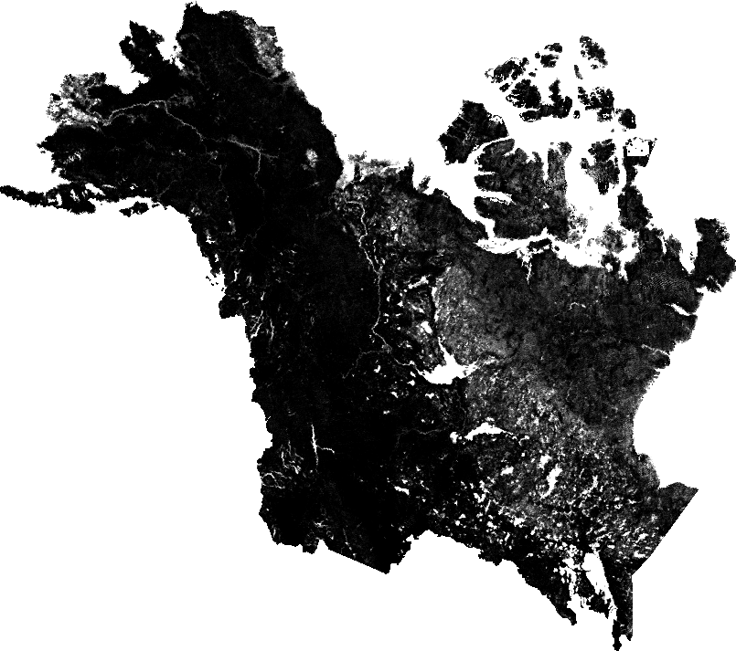
ABoVE: Wildfire Date of Burning within Fire Scars across Alaska and Canada, 2001-2019 NGDA recent views
This dataset provides estimates of wildfire progression represented by date of burning (DoB) within fire scars across Alaska and Canada for the period 2001-2019. Burn scar... -
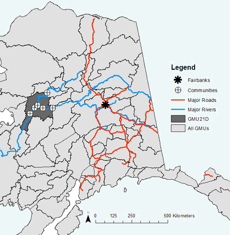
ABoVE: Environmental Conditions During Fall Moose Hunting Seasons, Alaska, 2000-2016 NGDA recent views
This dataset provides daily and annual air temperature, river water level, and leaf drop dates coincident with the moose (Alces alces) hunting season (September) for the area... -
ISLSCP II Historical Croplands Cover, 1700-1992 NGDA recent views
The Historical Croplands Cover data set was developed to understand the consequences of historical changes in land use and land cover for ecosystem goods and services. In... -
MODIS NDVI Data, Smoothed and Gap-filled, for the Conterminous US: 2000-2015 NGDA recent views
This data set provides Moderate Resolution Imaging Spectroradiometer (MODIS) normalized difference vegetation index (NDVI) data, smoothed and gap-filled, for the conterminous US... -
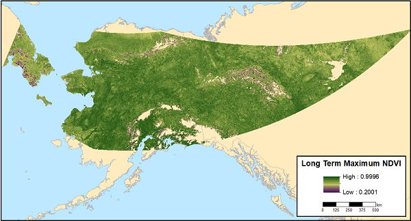
ABoVE: MODIS-derived Maximum NDVI, Northern Alaska and Yukon Territory for 2002-2017 NGDA recent views
This dataset provides the maximum Normalized Difference Vegetation Index (NDVI) at 1-km resolution over northern Alaska, USA and the Yukon Territory, Canada for each year from... -
LBA-ECO LC-22 Land Cover from MODIS Vegetation Indices, Mato Grosso, Brazil NGDA recent views
This data set, LBA-ECO LC-22 Land Cover from MODIS Vegetation Indices, Mato Grosso, Brazil, provides land cover classifications for Mato Grosso, Brazil, for the years 2000-2001... -
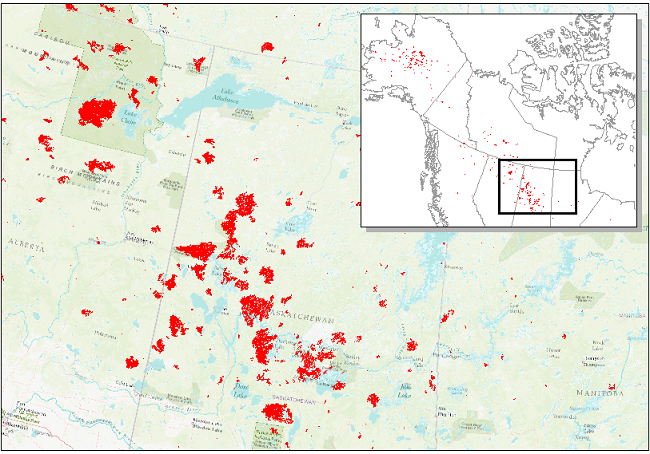
Annual wildland fire emissions (WFEIS v0.5) for Conterminous US and Alaska, 2001-2013 NGDA recent views
This data set contains annual modeled estimates of wildland fire emissions at 0.01 degree (~1-km) spatial resolution from the Wildland Fire Emissions Information System (WFEIS... -
ISLSCP II C4 Vegetation Percentage NGDA recent views
The photosynthetic composition (C3 or C4) of vegetation on the land surface is essential for accurate simulations of biosphere-atmosphere exchanges of carbon, water, and energy.... -
ABoVE: Wolf Denning Phenology and Reproductive Success, Alaska and Canada, 2000-2017 NGDA recent views
This dataset provides annual gray wolf (Canis lupus) denning spatial information and timing, associated climatic and phenologic metrics, and reproductive success (i.e., pup...

Official websites use .gov
A
.gov website belongs to an official government
organization in the United States.
Secure .gov websites use HTTPS
A
lock (
) or https:// means you’ve safely connected to
the .gov website. Share sensitive information only on official,
secure websites.