
-
Global Forest Ecosystem Structure and Function Data For Carbon Balance Research recent views
A comprehensive global database has been assembled to quantify CO2 fluxes and pathways across different levels of integration (from photosynthesis up to net ecosystem... -
Nitrogen Deposition onto the United States and Western Europe recent views
This data set contains data for wet and dry nitrogen-species deposition for the United States and Western Europe. Deposition data were acquired directly from monitoring programs... -
Burned and Unburned Field Site Data, Noatak, Seward, and North Slope, AK, 2016-2018 recent views
This dataset includes field measurements from unburned and burned 10 m x 10 m and 1 m x 1 m plots in the Noatak, Seward, and North Slope regions of the Alaskan tundra during... -
ABoVE: Synthesis of Burned and Unburned Forest Site Data, AK and Canada, 1983-2016 recent views
This dataset is a synthesis of field plot characterization data, derived above-ground and below-ground combusted carbon, and acquired Fire Weather Index (FWI) System components... -
ABoVE: Burned Area, Depth, and Combustion for Alaska and Canada, 2001-2019 NGDA recent views
This dataset provides annual gridded estimates of fire locations and associated burn fraction per pixel for Alaska and Canada at approximately 500 m spatial resolution for the... -
CARVE: Alaskan Fire Emissions Database (AKFED), 2001-2013 NGDA recent views
This data set provides estimates of annual carbon emissions (kg carbon per square meter) from boreal fires at 450-m resolution for the state of Alaska between 2001 and 2013. To... -
SAFARI 2000 Biomass Burning Emissions, Selected Sites, Dry Season 2000 recent views
Biomass burning is a major source for gaseous and particulate atmospheric pollution over southern Africa and globally. The purpose of this study was to quantify biomass burning... -
Annual wildland fire emissions (WFEIS v0.5) for Conterminous US and Alaska, 2001-2013 NGDA recent views
This data set contains annual modeled estimates of wildland fire emissions at 0.01 degree (~1-km) spatial resolution from the Wildland Fire Emissions Information System (WFEIS... -
Woody and Herbaceous Vegetation Change across the Savannas of West Africa, 1982-2013 recent views
The WAVeTrends dataset is a 0.05 degree (5.55 km) vegetation change product, spanning the West African Sudano-Sahel region. It provides pixel-wise information on concurrent... -
Soil Moisture Active Passive (SMAP) L4 Carbon Ancillary Biome Parameter Look Up Table V001 recent views
This ancillary SMAP product contains biophysical characteristics (biome parameters) used to estimate carbon fluxes and soil organic carbon in the SMAP L4 Carbon algorithm.... -
SAFARI 2000 1-Degree Estimates of Burned Biomass, Area, and Emissions, 2000 NGDA recent views
A new method is used to generate spatial estimates of monthly averaged biomass burned area and spatial and temporal estimates of trace gas and aerosol emissions from open fires... -
SAFARI 2000 Emissions Estimates, MODIS Burned Area Product, Dry Season 2000 NGDA recent views
The recently generated MODIS burned area product over southern Africa for the month of September 2000 was used to calculate regional biomass burning emissions from grassland and... -
Global N Cycle: Fluxes and N2O Mixing Ratios Originating from Human Activity recent views
Nitrogen is a major nutrient in terrestrial ecosystems and an important catalyst in tropospheric photochemistry. Over the last century human activities have dramatically... -
NACP Regional: Gridded 1-deg Observation Data and Biosphere and Inverse Model Outputs NGDA recent views
This data set contains standardized gridded observation data, terrestrial biosphere model output data, and inverse model simulations of carbon flux parameters that were used in... -
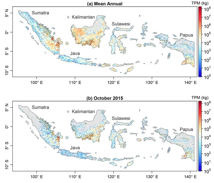
Fire Particulate Emissions from Combined VIIRS and AHI Data for Indonesia, 2015-2020 recent views
This dataset provides 10-minute fire emissions within 0.1-degree regularly spaced intervals across Indonesia from July 2015 to December 2020. The dataset was produced with a... -
Geoecology: County-Level Environmental Data for the United States, 1941-1981 recent views
The Geoecology database is a compilation of environmental data for the period 1941 to 1981. The Geoecology database contains selected data on terrain and soils, water resources,...

Official websites use .gov
A
.gov website belongs to an official government
organization in the United States.
Secure .gov websites use HTTPS
A
lock (
) or https:// means you’ve safely connected to
the .gov website. Share sensitive information only on official,
secure websites.