Woody and Herbaceous Vegetation Change across the Savannas of West Africa, 1982-2013
Access & Use Information
Downloads & Resources
-
Google Scholar search resultsHTML
Search results for publications that cite this dataset by its DOI.
-
Download this datasetHTML
This link allows direct data access via Earthdata login
-
View documentation related to this datasetHTML
ORNL DAAC Data Set Documentation
-
This dataset's landing pageHTML
Data set Landing Page DOI URL
-
View documentation related to this datasetPDF
West African Vegetation Trends (WAVeTrends): WAVeTrends.pdf
-
View documentation related to this datasetPDF
West African Vegetation Trends (WAVeTrends): WAVeTrends_classify.pdf
-
Get a related visualizationPNG
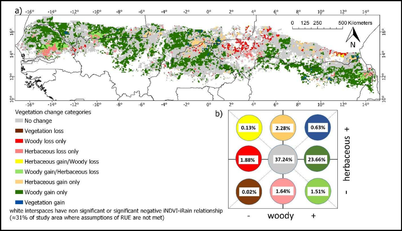
Concurrent woody and herbaceous vegetation changes between the 1982-1991 and...
-
Landing PageLanding Page
Dates
| Metadata Created Date | September 27, 2023 |
|---|---|
| Metadata Updated Date | December 7, 2023 |
Metadata Source
- Data.json Data.json Metadata
Harvested from NASA Data.json
Graphic Preview

Additional Metadata
| Resource Type | Dataset |
|---|---|
| Metadata Created Date | September 27, 2023 |
| Metadata Updated Date | December 7, 2023 |
| Publisher | ORNL_DAAC |
| Maintainer | |
| Identifier | C2764722720-ORNL_CLOUD |
| Data First Published | 2020-05-07 |
| Language | en-US |
| Data Last Modified | 2023-09-11 |
| Category | Vegetation, geospatial |
| Public Access Level | public |
| Bureau Code | 026:00 |
| Metadata Context | https://project-open-data.cio.gov/v1.1/schema/catalog.jsonld |
| Metadata Catalog ID | https://data.nasa.gov/data.json |
| Schema Version | https://project-open-data.cio.gov/v1.1/schema |
| Catalog Describedby | https://project-open-data.cio.gov/v1.1/schema/catalog.json |
| Citation | Anchang, J.Y., L. Prihodko, A.T. Kaptue, C.W. Ross, W. Ji, S.S. Kumar, B. Lind, M.A. Sarr, A.A. Diouf, and N.P. Hanan. 2020. Woody and Herbaceous Vegetation Change across the Savannas of West Africa, 1982-2013. ORNL DAAC, Oak Ridge, Tennessee, USA. https://doi.org/10.3334/ORNLDAAC/1738 |
| Graphic Preview Description | Concurrent woody and herbaceous vegetation changes between the 1982-1991 and 2004-2013 decades of the Sudano-Sahel region of Africa. (A) Map of vegetation change categories. (B) Chart showing the conceptual position and the relative abundance of each category in a 2-D space (Anchang et al. 2019). |
| Graphic Preview File | https://daac.ornl.gov/VEGETATION/guides/WAVeTrends_Fig1.png |
| Harvest Object Id | 46dd7607-372a-459d-965b-315492a52a4c |
| Harvest Source Id | 58f92550-7a01-4f00-b1b2-8dc953bd598f |
| Harvest Source Title | NASA Data.json |
| Homepage URL | https://doi.org/10.3334/ORNLDAAC/1738 |
| Metadata Type | geospatial |
| Old Spatial | -17.14 9.96 15.31 17.41 |
| Program Code | 026:001 |
| Source Datajson Identifier | True |
| Source Hash | 47cc077215a2fccde8af13ff1d75e1c5072e5316cfad063676cbc238a737b485 |
| Source Schema Version | 1.1 |
| Spatial | |
| Temporal | 1982-01-01T00:00:00Z/2013-12-31T23:59:59Z |
Didn't find what you're looking for? Suggest a dataset here.

