
-
State
Alaska landslide inventory database
State of Alaska —
Alaska landslide inventory database, Digital Data Series 23, provides a catalog of slope instabilities across Alaska and documents the development of the Alaska... -
Federal
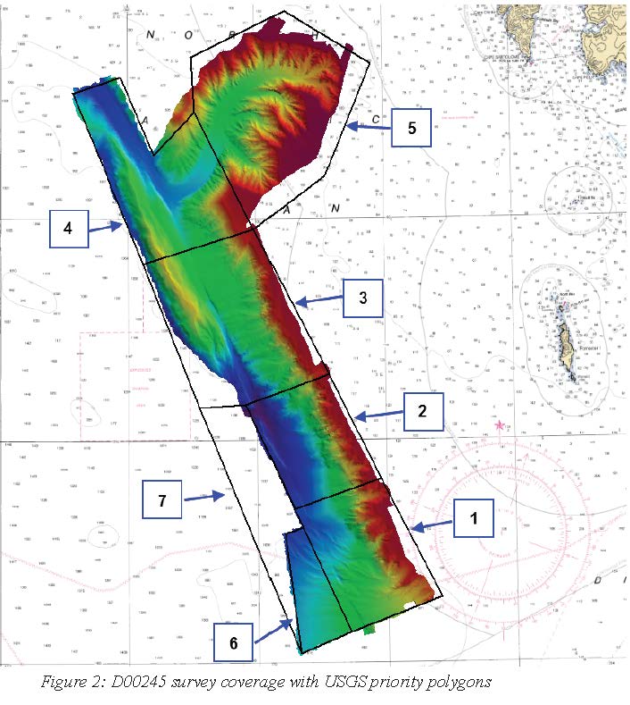
D00245: NOS Hydrographic Survey , 2018-06-29
National Oceanic and Atmospheric Administration, Department of Commerce —
The National Oceanic and Atmospheric Administration (NOAA) has the statutory mandate to collect hydrographic data in support of nautical chart compilation for safe... -
State
Thin section analysis of samples from the Haines-Takshanuk Mountains-Chilkat Peninsula area STATEMAP project, Southeast Alaska, collected 2022 and 2023
State of Alaska —
Thin section analysis of samples from the Haines-Takshanuk Mountains-Chilkat Peninsula area STATEMAP project, Southeast Alaska, collected 2022 and 2023, Raw Data File... -
Federal
Harbor porpoise (Phocoena phocoena) abundance survey conducted during visual observations from a vessel platform in the coastal waters of Southeast Alaska by the Alaska Fisheries Science Center Cetacean Assessment and Ecology Program from 2019-07-19 to 2019-08-12 (NCEI Accession 0277244)
National Oceanic and Atmospheric Administration, Department of Commerce —
This dataset includes visual line transect survey data collected in the summer of 2019 in the waters of Southeast Alaska. The survey was designed for updating the... -
Federal
High-resolution record of surface seawater carbon dioxide (CO2) content, water temperature, sea surface salinity and other parameters collected in Sitka Harbor, Alaska, USA from 2017-06-01 to 2021-04-27 (NCEI Accession 0247208)
National Oceanic and Atmospheric Administration, Department of Commerce —
This dataset includes measurements of partial pressure of carbon dioxide (pCO2), sea surface salinity, sea surface temperature and other parameters collected in Sitka... -
Federal
AFSC/ABL: NPRB project 1106 Improved aging estimates for spiny dogfish
National Oceanic and Atmospheric Administration, Department of Commerce —
The spiny dogfish (Squalus suckleyi, formerly Squalus acanthias, Ebert et al. 2010) is a small, long-lived and slow-growing shark, which is vulnerable to overfishing.... -
Federal
Elfin Cove Alaska 1/3 arc-second MHW Coastal Digital Elevation Model
National Oceanic and Atmospheric Administration, Department of Commerce —
NOAA's National Geophysical Data Center (NGDC) is building high-resolution digital elevation models (DEMs) to support individual coastal States as part of the... -
State
Soil index properties and radiocarbon ages of the Haines-Takshanuk Mountains-Chilkat Peninsula area statemap project, Southeast Alaska
State of Alaska —
Soil index properties and radiocarbon ages of the Haines-Takshanuk Mountains-Chilkat Peninsula area statemap project, Southeast Alaska, Raw Data File 2024-27,... -
Federal
AFSC/ABL: Embryonic development of quillback rockfish
National Oceanic and Atmospheric Administration, Department of Commerce —
Maternal effects on the quality of progeny can have direct impacts on population productivity. Rockfish are viviparous and the oil globule size of larvae at... -
Federal
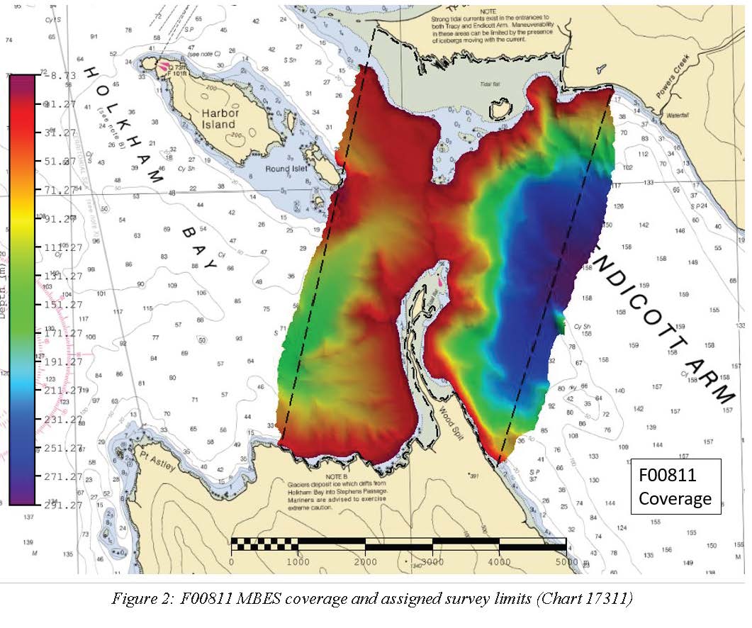
F00811: NOS Hydrographic Survey , 2020-10-10
National Oceanic and Atmospheric Administration, Department of Commerce —
The National Oceanic and Atmospheric Administration (NOAA) has the statutory mandate to collect hydrographic data in support of nautical chart compilation for safe... -
Federal
Dissolved inorganic carbon, total alkalinity, pH, nutrients, and other variables collected from surface only or profile discrete sampling observations using Niskin bottle and other instruments in the Gulf of Alaska region from 2007-05-19 to 2013-07-22 (NCEI Accession 0132049)
National Oceanic and Atmospheric Administration, Department of Commerce —
This dataset includes environmental data from the Gulf of Alaska region. Samples were collected between May 2007 and July 2013. -
State
Regional tsunami hazard assessment for the communities of Kasaan, Klawock, Metlakatla, Pelican, Point Baker, and Port Protection in Southeast Alaska
State of Alaska —
We assess potential tsunami hazards for six communities in Southeast Alaska: Kasaan, Klawock, Metlakatla, Pelican, Point Baker, and Port Protection. These communities... -
State
Landslide hazard susceptibility mapping in Haines, Alaska
State of Alaska —
Landslide hazard susceptibility mapping in Haines, Alaska, Report of Investigation 2024-8, provides a map and database of historical and prehistoric slope failures,... -
State
High-resolution lidar data for the Chilkat Ridge area, Alaska
State of Alaska —
The State of Alaska Division of Geological & Geophysical Surveys (DGGS) used lidar to produce a digital terrain model (DTM) and digital surface model (DSM) over... -
Federal
Southeast Alaska ESI: ESI (Environmental Sensitivity Index Shoreline Types - Polygons and Lines)
National Oceanic and Atmospheric Administration, Department of Commerce —
This data set contains vector lines and polygons representing the shoreline and coastal habitats of Southeast Alaska classified according to the Environmental... -
Federal
Southeast Alaska ESI: T_MAMMAL (Terrestrial Mammal Polygons)
National Oceanic and Atmospheric Administration, Department of Commerce —
This data set contains biological resource data for brown bears in Southeast Alaska. Vector polygons in this data set represent locations of bear concentrations.... -
Federal
Southeast Alaska ESI: HABITATS (Habitat and Plant Polygons)
National Oceanic and Atmospheric Administration, Department of Commerce —
This data set contains biological resource data for seagrass habitats in Southeast Alaska. Vector polygons in this data set represent locations of seagrass... -
State
Lidar-derived elevation data for Mount Juneau, Southeast Alaska, collected September 6, 2019
State of Alaska —
The Alaska Division of Geological & Geophysical Surveys (DGGS) used aerial lidar to produce a classified point cloud, digital surface model (DSM), digital terrain...

Official websites use .gov
A
.gov website belongs to an official government
organization in the United States.
Secure .gov websites use HTTPS
A
lock (
) or https:// means you’ve safely connected to
the .gov website. Share sensitive information only on official,
secure websites.