
-
Federal
Global Historical Climatology Network - Monthly (GHCN-M), Version 2 recent views
National Oceanic and Atmospheric Administration, Department of Commerce —
Please note, the temperature portion of this dataset has been superseded by a newer version. Users should not use this version except in rare cases (e.g., when... -
Federal
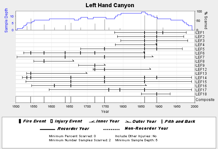
NOAA/WDS Paleoclimatology - Brown fire data from Left Hand Canyon - IMPD USLEF001 recent views
National Oceanic and Atmospheric Administration, Department of Commerce —
This archived Paleoclimatology Study is available from the NOAA National Centers for Environmental Information (NCEI), under the World Data Service (WDS) for... -
Federal
Puget Sound 1/3 arc-second NAVD 88 Coastal Digital Elevation Model recent views
National Oceanic and Atmospheric Administration, Department of Commerce —
NOAA's National Geophysical Data Center (NGDC) is building high-resolution digital elevation models (DEMs) for select U.S. coastal regions. These integrated... -
Federal
NOAA Next Generation Radar (NEXRAD) Level 3 Products recent views
National Oceanic and Atmospheric Administration, Department of Commerce —
This dataset consists of Level 3 weather radar products collected from Next-Generation Radar (NEXRAD) stations located in the contiguous United States, Alaska,... -
Federal
NOAA Climate Data Record (CDR) of Gridded Satellite Data from ISCCP B1 (GridSat-B1) Infrared Channel Brightness Temperature, Version 2 recent views
National Oceanic and Atmospheric Administration, Department of Commerce —
The Gridded Satellite (GridSat-B1) data provides a uniform set of quality controlled geostationary satellite observations for the visible, infrared window and... -
Federal
Regional Snowfall Index (RSI) recent views
National Oceanic and Atmospheric Administration, Department of Commerce —
The Regional Snowfall Index (RSI) is an index of significant snowstorms that impact the eastern two thirds of the U.S. The RSI ranks snowstorm impacts on a scale from... -
Federal
Cetacean and sea turtle spatial density model outputs from visual observations using line-transect survey methods aboard NOAA vessel and aircraft platforms in the Gulf of Mexico from 2003-06-12 to 2019-07-31 (NCEI Accession 0256800) recent views
National Oceanic and Atmospheric Administration, Department of Commerce —
Based on ship-based and aerial line-transect surveys conducted in the U.S. waters of the Gulf of Mexico between 2003 and 2019, the NOAA Southeast Fisheries Science... -
Federal
EMAG2v3: Earth Magnetic Anomaly Grid (2-arc-minute resolution) recent views
National Oceanic and Atmospheric Administration, Department of Commerce —
EMAG2v3 is a global Earth Magnetic Anomaly Grid compiled from satellite, ship, and airborne magnetic measurements. It is a significant update of the previous release... -
Federal
National Solar Radiation Database (NSRDB) SolarAnywhere 10 km Model Output for 1989 to 2009 recent views
National Oceanic and Atmospheric Administration, Department of Commerce —
The National Solar Radiation Database (NSRDB) was produced by the National Renewable Energy Laboratory under the U.S. Department of Energy's Office of Energy... -
Federal
Global Summary of the Year (GSOY), Version 1 recent views
National Oceanic and Atmospheric Administration, Department of Commerce —
This Global Summaries dataset, known as GSOY for Yearly, contains a yearly resolution of meteorological elements from 1763 to present with updates applied weekly. The... -
Federal
H02393: NOS Hydrographic Survey recent views
National Oceanic and Atmospheric Administration, Department of Commerce —
The National Oceanic and Atmospheric Administration (NOAA) has the statutory mandate to collect hydrographic data in support of nautical chart compilation for safe... -
Federal
NESDIS Suspected Oil: Marine Pollution Surveillance Reports (MPSR) Metadata recent views
National Oceanic and Atmospheric Administration, Department of Commerce —
The Satellite Analysis Branch (SAB) of NOAA/NESDIS detects oil slicks in satellite imagery over U.S. waters (and international waters when requested by OR&R) in... -
Federal
Humpback Whale Sound Production Recorded at SanctSound Site SB02_02 recent views
National Oceanic and Atmospheric Administration, Department of Commerce —
This record represents humpback whale sound production detected from raw passive acoustic data. The Low Frequency Detection and Classification System (LFDCS) call... -
Federal
U.S. Climate Normals 2020: U.S. Daily Climate Normals (1991-2020) recent views
National Oceanic and Atmospheric Administration, Department of Commerce —
The Daily Climate Normals for 1991 to 2020 are 30-year averages of meteorological parameters that provide users the information needed to understand typical climate... -
Federal
Snowstorm Database recent views
National Oceanic and Atmospheric Administration, Department of Commerce —
The Snowstorm Database is a collection of over 500 snowstorms dating back to 1900 and updated operationally. Only storms having large areas of heavy snowfall (10-20... -
Federal
EK80 Water Column Sonar Data Collected During DY2002 recent views
National Oceanic and Atmospheric Administration, Department of Commerce —
The Midwater Assessment and Conservation Engineering (MACE) program of NOAA Fisheries, Alaska Fisheries Science Center (AFSC) conducted an acoustic-trawl (AT) stock... -
Federal
EX2103: 2021 ROV Shakedown (ROV & Mapping) recent views
National Oceanic and Atmospheric Administration, Department of Commerce —
This Remotely Operated Vehicle (ROV) shakedown expedition aboard NOAA Ship Okeanos Explorer began in Norfolk, Virginia on June 13, 2021 and concluded on June 28, 2021... -
Federal
NOAA High-Resolution Sea Surface Temperature (SST) Analysis Products NGDA recent views
National Oceanic and Atmospheric Administration, Department of Commerce —
This archive covers two high resolution sea surface temperature (SST) analysis products developed using an optimum interpolation (OI) technique. The analyses have a... -
Federal
Global Marine Observations in 10-degree Bins derived from the International Comprehensive Ocean-Atmosphere Data Set (ICOADS) recent views
National Oceanic and Atmospheric Administration, Department of Commerce —
The Global Marine Observations in 10-degree bins are reformatted data from the International Comprehensive Ocean Atmosphere Data Set (ICOADS). ICOADS consists of... -
Federal
NCEP North American Regional Reanalysis (NARR), for 1979 to Present recent views
National Oceanic and Atmospheric Administration, Department of Commerce —
The North America Regional Reanalysis (NARR) Project is a reanalysis of historical observations using a 32-km version of the National Centers for Environmental...

Official websites use .gov
A
.gov website belongs to an official government
organization in the United States.
Secure .gov websites use HTTPS
A
lock (
) or https:// means you’ve safely connected to
the .gov website. Share sensitive information only on official,
secure websites.