
-
Federal
Shoreline Mapping Program of KODIAK ISLAND, SITKALIDAK STRAIT TO UGAK ISLAND, AK, AK0603B NGDA
National Oceanic and Atmospheric Administration, Department of Commerce —
These data provide an accurate high-resolution shoreline compiled from imagery of KODIAK ISLAND, SITKALIDAK STRAIT TO UGAK ISLAND, AK . This vector shoreline data is... -
Federal
H06829: NOS Hydrographic Survey , 1947-07-22
National Oceanic and Atmospheric Administration, Department of Commerce —
The National Oceanic and Atmospheric Administration (NOAA) has the statutory mandate to collect hydrographic data in support of nautical chart compilation for safe... -
Federal
H13002: NOS Hydrographic Survey , 2017-06-12
National Oceanic and Atmospheric Administration, Department of Commerce —
The National Oceanic and Atmospheric Administration (NOAA) has the statutory mandate to collect hydrographic data in support of nautical chart compilation for safe... -
Federal
Larsen Bay, Alaska 8/15 arc-second MHHW Coastal Digital Elevation Model
National Oceanic and Atmospheric Administration, Department of Commerce —
NOAA's National Centers for Environmental Information is building high-resolution digital elevation models (DEMs) to support individual coastal States as part of the... -
Federal
AFSC/RACE/SAP/Foy: Seawater chemistry of three pH treatments used to test the effect of pH on Tanner crab biology: Kodiak Island, Alaska.
National Oceanic and Atmospheric Administration, Department of Commerce —
To study the effects of ocean acidification we examined the effects of ocean acidification on the embryo and larval stages of the economically important southern... -
Federal
TIGER/Line Shapefile, 2021, County, Kodiak Island Borough, AK, All Roads
U.S. Census Bureau, Department of Commerce —
The TIGER/Line shapefiles and related database files (.dbf) are an extract of selected geographic and cartographic information from the U.S. Census Bureau's Master... -
Federal
Obsolete - AFSC/RACE/EcoFOCI: 2011 Gulf of Alaska Late Larval Survey DY11-02/2DY11
National Oceanic and Atmospheric Administration, Department of Commerce —
A total of 70 stations were occupied. The standard FOCI grid and line 8 were samped. At each station we sampled using paired 20 and 60 cm Bongo frames (150 and 500... -
Federal
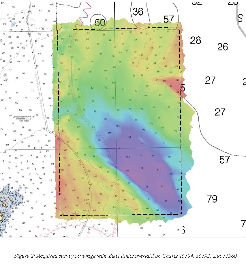
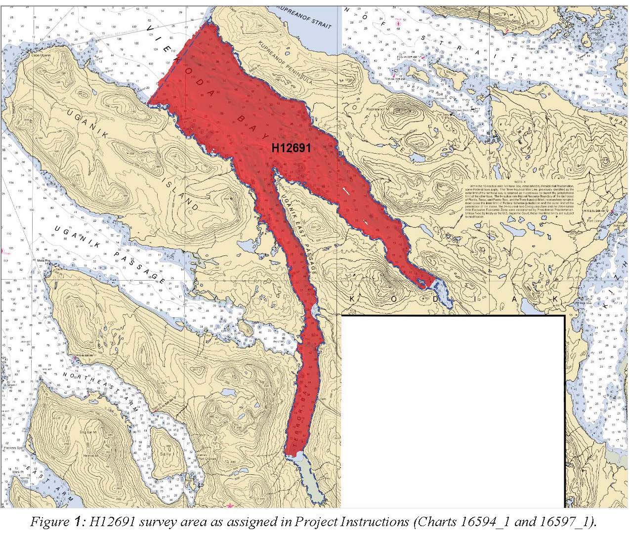
H12691: NOS Hydrographic Survey , 2015-10-21
National Oceanic and Atmospheric Administration, Department of Commerce —
The National Oceanic and Atmospheric Administration (NOAA) has the statutory mandate to collect hydrographic data in support of nautical chart compilation for safe... -
Federal
H12319: NOS Hydrographic Survey , North Coast of Kodiak Island, 2012-09-27
National Oceanic and Atmospheric Administration, Department of Commerce —
The National Oceanic and Atmospheric Administration (NOAA) has the statutory mandate to collect hydrographic data in support of nautical chart compilation for safe... -
State
Regional tsunami hazard assessment for selected communities on Kodiak Island, Alaska
State of Alaska —
We assess potential tsunami hazard for the following seven coastal communities on Kodiak Island, Alaska: Akhiok, Chiniak, Karluk, Larsen Bay, Old Harbor, Ouzinkie,... -
Federal
Kodiak, Alaska 8 arc-second MHW Coastal Digital Elevation Model
National Oceanic and Atmospheric Administration, Department of Commerce —
The 8-second Kodiak, Alaska Elevation Grid provides bathymetric data of 8-second resolution in geographic coordinates. This grid is strictly for tsunami inundation... -
Federal
AFSC/RACE/FBEP/Ryer: Polychaete worm tubes modify juvenile northern rock sole Lepidopsetta polyxystra depth distribution in Kodiak nurseries
National Oceanic and Atmospheric Administration, Department of Commerce —
This dataset is from a study that evaluates whether inter-annual variability in the depth distribution of juvenile northern rock sole on their nursery grounds around... -
Federal
Obsolete - AFSC/RACE/EcoFOCI: 2011 GOA-IERP & Seward Line 1TX11
National Oceanic and Atmospheric Administration, Department of Commerce —
1.Conduct tandem 20 cm (153 mesh size) and 60 cm (505 mesh size) Bongo net tows at all grid stations (Table 2) working from west to east. Deployments were made aft... -
Federal
AFSC/RACE/FBEP/Laurel: Effects of natural and anthropogenic disturbance on polychaete worm tubes and age-0 flatfish distribution
National Oceanic and Atmospheric Administration, Department of Commerce —
This dataset is from a field experiment that examined how juvenile flatfish distribution changed with worm tube heterogeneity, i.e. density and patchiness. -
Federal
AFSC/RACE/SAP/Foy: Effects of ocean acidification on embryo stages of Tanner crab: Kodiak Island, Alaska.
National Oceanic and Atmospheric Administration, Department of Commerce —
To study the effects of ocean acidification we examined the effects of ocean acidification on the embryo stages of the economically important southern Tanner crab,... -
Federal
H13104: NOS Hydrographic Survey , 2019-06-20
National Oceanic and Atmospheric Administration, Department of Commerce —
The National Oceanic and Atmospheric Administration (NOAA) has the statutory mandate to collect hydrographic data in support of nautical chart compilation for safe... -
Federal
H13000: NOS Hydrographic Survey , 2017-06-30
National Oceanic and Atmospheric Administration, Department of Commerce —
The National Oceanic and Atmospheric Administration (NOAA) has the statutory mandate to collect hydrographic data in support of nautical chart compilation for safe... -
Federal
H12999: NOS Hydrographic Survey , 2017-06-30
National Oceanic and Atmospheric Administration, Department of Commerce —
The National Oceanic and Atmospheric Administration (NOAA) has the statutory mandate to collect hydrographic data in support of nautical chart compilation for safe... -
Federal
H13003: NOS Hydrographic Survey , 2017-08-14
National Oceanic and Atmospheric Administration, Department of Commerce —
The National Oceanic and Atmospheric Administration (NOAA) has the statutory mandate to collect hydrographic data in support of nautical chart compilation for safe...

Official websites use .gov
A
.gov website belongs to an official government
organization in the United States.
Secure .gov websites use HTTPS
A
lock (
) or https:// means you’ve safely connected to
the .gov website. Share sensitive information only on official,
secure websites.