
-
Federal
VEMAP 2: Annual Ecosystem Model Responses to U.S. Climate Change, 1994-2100 11 recent views
National Aeronautics and Space Administration —
Phase 2 of the VEMAP Project developed historical (1895-1993) gridded data sets of climate (temperature, precipitation, solar radiation, humidity, and wind speed) and... -
Federal
CLPX-Model: Land Data Assimilation System (LDAS) Data, Version 1
National Aeronautics and Space Administration —
The LDAS data set contains 43 model and observation-based fields produced by the LDAS uncoupled modeling system at the NASA Goddard Space Flight Center using the... -
Federal
MODIS/Terra+Aqua Downward Shortwave Radiation Daily/3-Hour L3 Global 0.05Deg CMG V061 NGDA
National Aeronautics and Space Administration —
The MCD18C1 Version 6.1 is a Moderate Resolution Imaging Spectroradiometer (MODIS) Terra and Aqua combined Downward Shortwave Radiation (DSR) Level 3 product produced... -
Federal
Land Surface Atmospheric Boundary Interaction Product L3 V1(LANDMET) at GES DISC
National Aeronautics and Space Administration —
This product is a multi-variate data compilation that reconciles the variation scales of these multiple measurements from varies resources, merges and maps them into... -
Federal
MISR Level 3 Component Global Land Product covering a year V004
National Aeronautics and Space Administration —
MIL3YLS_4 is the Multi-angle Imaging SpectroRadiometer (MISR) Level 3 Component Global Land Product covering a year version 4. It contains a statistical summary of... -
Federal
SMEX04 San Miguel Watershed Soil Moisture Data: Sonora, Version 1
National Aeronautics and Space Administration —
Notice to Data Users: The documentation for this data set was provided solely by the Principal Investigator(s) and was not further developed, thoroughly reviewed, or... -
Federal
ISLSCP II Continuous Fields of Vegetation Cover, 1992-1993 NGDA
National Aeronautics and Space Administration —
The objective of this study was to derive continuous fields of vegetation cover from multi-temporal Advanced Very High Resolution Radiometer (AVHRR) data using all... -
Federal
SAFARI 2000 AVHRR-derived Land Surface Temperature Maps, Africa, 1995-2000
National Aeronautics and Space Administration —
Land Surface Temperature (LST) is a key indicator of land surface states, and can provide information on surface-atmosphere heat and mass fluxes, vegetation water... -
Federal
ISLSCP II IGBP DISCover and SiB Land Cover, 1992-1993 NGDA
National Aeronautics and Space Administration —
This data set describes the geographic distributions of 17 classes of land cover based on the International Geosphere-Biosphere DISCover land cover legend (Loveland... -
Federal
MODIS-derived Biophysical Parameters for 5-km Land Cover, North America, 2000-2012
National Aeronautics and Space Administration —
This data set provides MODIS-derived surface biophysical climatologies of bidirectional distribution function (BRDF), BDRF/albedo, land surface temperature (LST),... -
Federal
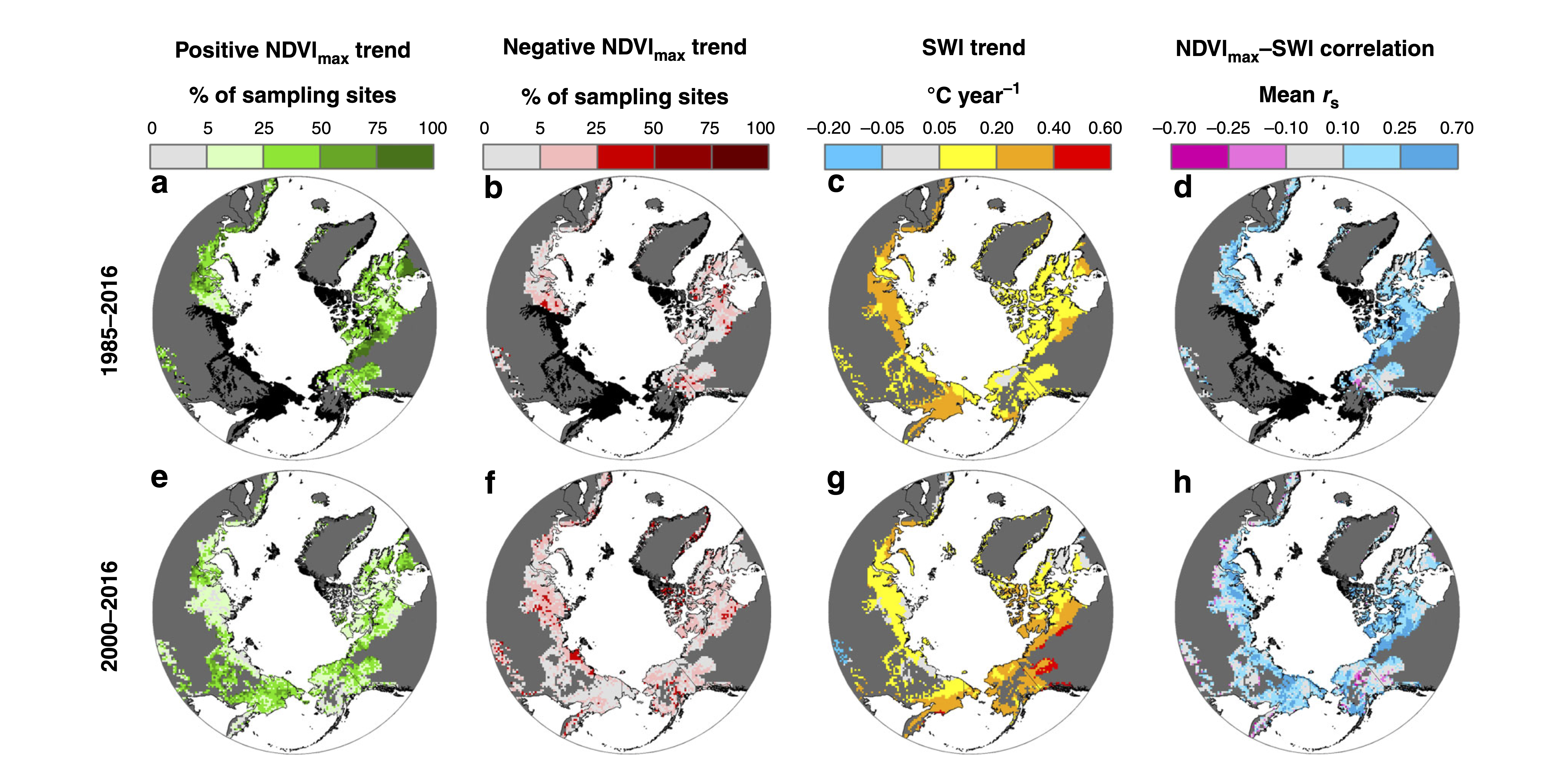
ABoVE: Landsat Tundra Greenness and Summer Air Temperatures, Arctic Tundra, 1985-2016
National Aeronautics and Space Administration —
This dataset provides annual tundra greenness and summer air temperatures at a resolution of 50 km over the pan-Arctic tundra biome above 31.5 degrees over the time... -
Federal
FLUXNET Research Network Site Characteristics, Investigators, and Bibliography, 2016
National Aeronautics and Space Administration —
FLUXNET is a global network of micrometeorological tower sites that use eddy covariance methods to measure the exchanges of carbon dioxide, water vapor, and energy... -
Federal
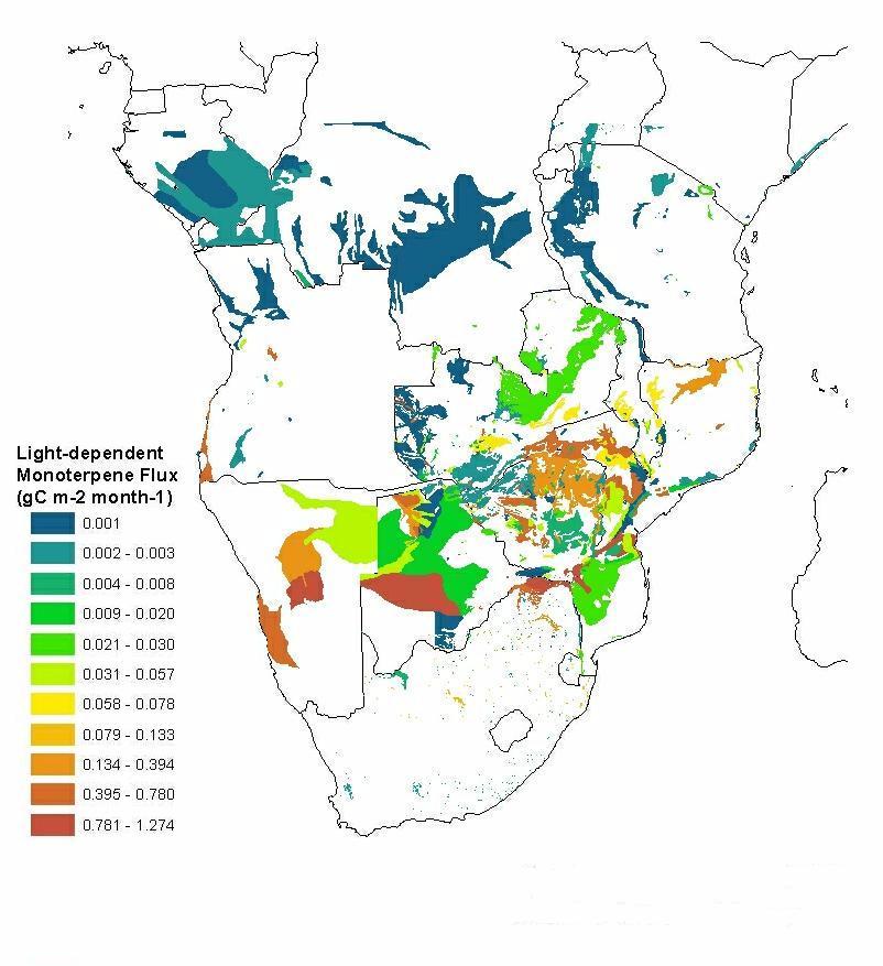
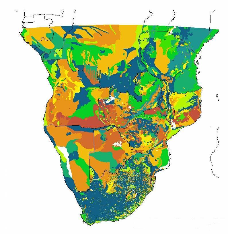
SAFARI 2000 Estimated BVOC Emissions for Southern African Land Cover Types NGDA
National Aeronautics and Space Administration —
Improved vegetation distribution and emission data for Africa south of the equator were developed for the Southern African Regional Science Initiative (SAFARI 2000)... -
Federal
SAFARI 2000 MODIS Water and Heat Fluxes, Maun, Botswana, Dry Season 2001 NGDA
National Aeronautics and Space Administration —
A physically-based model, Energy: Surface Towards Atmosphere (ESTA), was used to model and map the energy and water balances of a heterogeneous land surface in a... -
Federal
Geoecology: County-Level Environmental Data for the United States, 1941-1981
National Aeronautics and Space Administration —
The Geoecology database is a compilation of environmental data for the period 1941 to 1981. The Geoecology database contains selected data on terrain and soils, water... -
Federal
NACP MsTMIP: Global and North American Driver Data for Multi-Model Intercomparison
National Aeronautics and Space Administration —
This data set provides environmental data that have been standardized and aggregated for use as input to carbon cycle models at global (0.5-degree resolution) and... -
Federal
Mechanistic Module for Soil Nitrogen Emissions for CMAQ Model, North America, 2011
National Aeronautics and Space Administration —
This model product provides source code, input data files, and example model outputs for a new mechanistic soil nitrogen (N) module in-line with the Community... -
Federal
MISR Level 3 Component Global Land Regional public Product covering a month V002
National Aeronautics and Space Administration —
MI3MLSR_2 is the Multi-angle Imaging SpectroRadiometer (MISR) Level 3 Component Global Land Regional public Product covering a month version 2. It contains a daily... -
Federal
BOREAS TGB-12 Soil Carbon Data: NSA
National Aeronautics and Space Administration —
Contains the soil carbon data collected by TGB-12 in the northern study area. -
Federal
Archived SAFARI 2000 Project Website, October 2008
National Aeronautics and Space Administration —
This dataset contains an archived copy of the Safari 2000 Project website as of October 2008. This archived website is provided for informational purposes only. No...

Official websites use .gov
A
.gov website belongs to an official government
organization in the United States.
Secure .gov websites use HTTPS
A
lock (
) or https:// means you’ve safely connected to
the .gov website. Share sensitive information only on official,
secure websites.