
-
Federal
USGS Cruise 97009 Sidescan Sonar Data Files recent views
Department of the Interior —
This CD-ROM contains digital high resolution sidescan sonar data collected during the USGS Cruise 97009 aboard the R/V MS MS Coastal. This CD-ROM (Compact Disc-Read... -
Federal
U.S. Geological Survey East Coast Sediment Texture Database (ECSTDB2011.SHP, 2011) recent views
Department of the Interior —
This sediment database contains location, description, and texture of samples taken by numerous marine sampling programs. Most of the samples are from the Atlantic... -
Federal
Airborne geophysical survey: Southern South Carolina, South Carolina recent views
Department of the Interior —
Aeromagnetic data were collected along flight lines by instruments in an aircraft that recorded magnetic-field values and locations. This dataset presents latitude,... -
Federal
H11861: NOS Hydrographic Survey , Charleston Harbor, South Carolina, 2008-11-13 recent views
National Oceanic and Atmospheric Administration, Department of Commerce —
The National Oceanic and Atmospheric Administration (NOAA) has the statutory mandate to collect hydrographic data in support of nautical chart compilation for safe... -
Federal
Compiled reference list to support reservoir thermal energy storage research recent views
Department of the Interior —
This text file (Reference_List_V1.txt) lists references that describe relevant characteristics for reservoir thermal energy storage (RTES) research in the United... -
Federal
H04905: NOS Hydrographic Survey recent views
National Oceanic and Atmospheric Administration, Department of Commerce —
The National Oceanic and Atmospheric Administration (NOAA) has the statutory mandate to collect hydrographic data in support of nautical chart compilation for safe... -
Federal
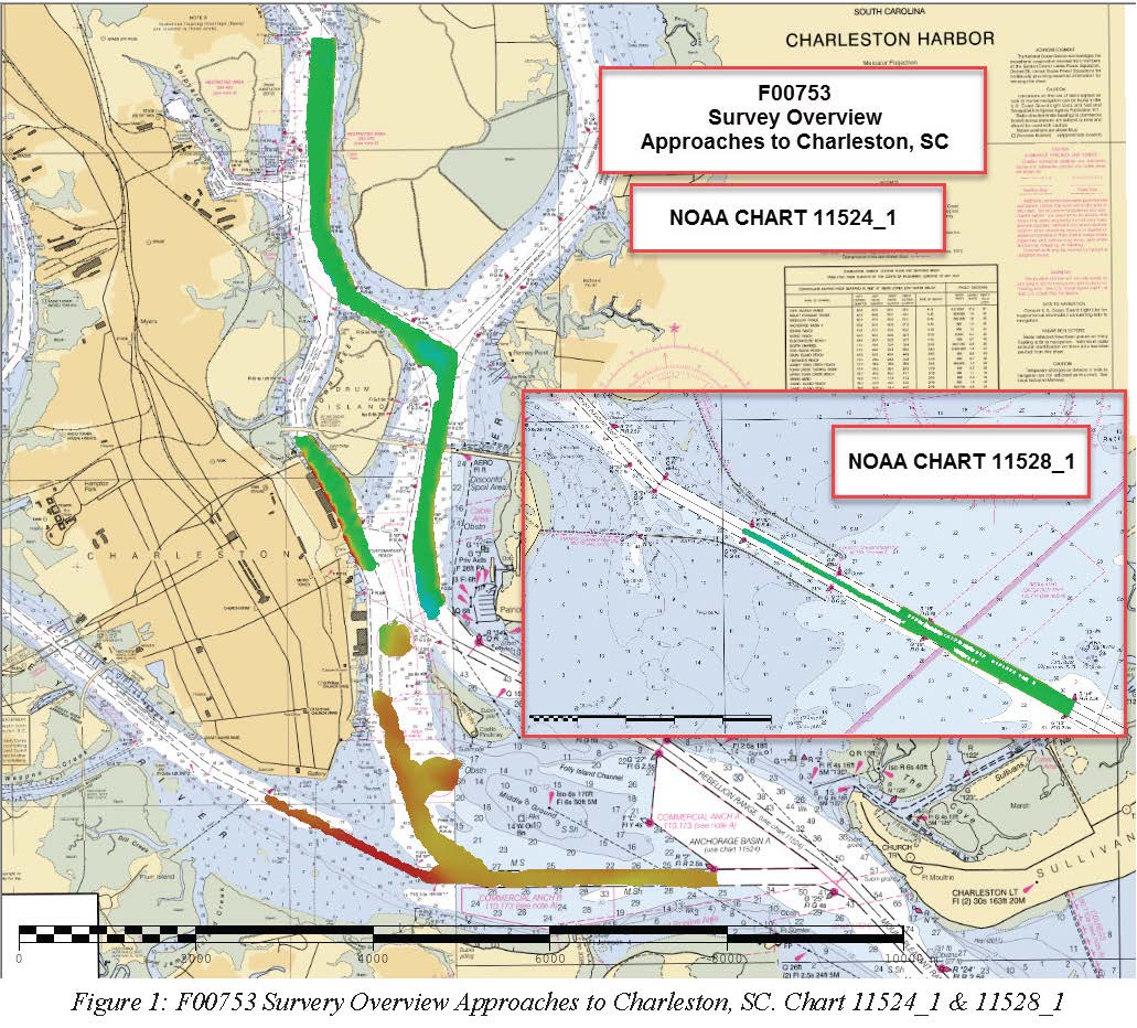
F00753: NOS Hydrographic Survey , 2018-10-23 recent views
National Oceanic and Atmospheric Administration, Department of Commerce —
The National Oceanic and Atmospheric Administration (NOAA) has the statutory mandate to collect hydrographic data in support of nautical chart compilation for safe... -
Federal
Shoreline Data Rescue Project of Charleston, SC to Savannah, GA, PH6407 NGDA recent views
National Oceanic and Atmospheric Administration, Department of Commerce —
These data were automated to provide an accurate high-resolution historical shoreline of Charleston, SC to Savannah, GA suitable as a geographic information system... -
Federal
Shoreline Data Rescue Project of Charleston, South Carolina, EC14C04 NGDA recent views
National Oceanic and Atmospheric Administration, Department of Commerce —
These data were automated to provide an accurate high-resolution historical shoreline of Charleston, South Carolina suitable as a geographic information system (GIS)... -
Federal
Shoreline Data Rescue Project of Charleston, South Carolina to Savannah, Georgia, EC15A01 NGDA recent views
National Oceanic and Atmospheric Administration, Department of Commerce —
These data were automated to provide an accurate high-resolution historical shoreline of Charleston, South Carolina to Savannah, Georgia suitable as a geographic... -
Federal
TIGER/Line Shapefile, 2022, County, Charleston County, SC, All Lines recent views
U.S. Census Bureau, Department of Commerce —
The TIGER/Line shapefiles and related database files (.dbf) are an extract of selected geographic and cartographic information from the U.S. Census Bureau's Master... -
Federal
CHIRP Subbottom Profiler Data for the US Atlantic Margin recent views
National Oceanic and Atmospheric Administration, Department of Commerce —
Knudsen 3260 CHIRP subbottom profiler - CHIRP Subbottom Profiler data were collected in Raw Knudsen SEG-Y Datagram format. -
Federal
H04909: NOS Hydrographic Survey , 1928-12-31 recent views
National Oceanic and Atmospheric Administration, Department of Commerce —
The National Oceanic and Atmospheric Administration (NOAA) has the statutory mandate to collect hydrographic data in support of nautical chart compilation for safe... -
Federal
H04904: NOS Hydrographic Survey recent views
National Oceanic and Atmospheric Administration, Department of Commerce —
The National Oceanic and Atmospheric Administration (NOAA) has the statutory mandate to collect hydrographic data in support of nautical chart compilation for safe... -
Federal
H04907: NOS Hydrographic Survey recent views
National Oceanic and Atmospheric Administration, Department of Commerce —
The National Oceanic and Atmospheric Administration (NOAA) has the statutory mandate to collect hydrographic data in support of nautical chart compilation for safe... -
Federal
TIGER/Line Shapefile, 2023, County, Charleston County, SC, Area Hydrography recent views
U.S. Census Bureau, Department of Commerce —
The TIGER/Line shapefiles and related database files (.dbf) are an extract of selected geographic and cartographic information from the U.S. Census Bureau's Master... -
Federal
Biological, chemical, and physical data from the Phytoplankton Monitoring Network from 2001-09-13 to 2013-03-07 (NCEI Accession 0117942) recent views
National Oceanic and Atmospheric Administration, Department of Commerce —
The Phytoplankton Monitoring Network (PMN) is a part of the National Centers for Coastal Ocean Science (NCCOS). The PMN was created as an outreach program to connect... -
Federal
F00551: NOS Hydrographic Survey , Charleston Harbor, South Carolina, 2007-02-11 recent views
National Oceanic and Atmospheric Administration, Department of Commerce —
The National Oceanic and Atmospheric Administration (NOAA) has the statutory mandate to collect hydrographic data in support of nautical chart compilation for safe... -
Federal
H04906: NOS Hydrographic Survey recent views
National Oceanic and Atmospheric Administration, Department of Commerce —
The National Oceanic and Atmospheric Administration (NOAA) has the statutory mandate to collect hydrographic data in support of nautical chart compilation for safe... -
Federal
Database for the Surficial Geologic Map of the Charleston Region, Berkeley, Charleston, Colleton, Dorchester, and Georgetown Counties, South Carolina recent views
Department of the Interior —
This database portrays the surface and shallow subsurface geology of the greater Charleston, S.C. region east of 80°30′ west and south of 33°15′ north. The region...

Official websites use .gov
A
.gov website belongs to an official government
organization in the United States.
Secure .gov websites use HTTPS
A
lock (
) or https:// means you’ve safely connected to
the .gov website. Share sensitive information only on official,
secure websites.
.jpg)