
-
Federal
Climatic controls on the global distribution, abundance, and species richness of mangrove forests
Department of the Interior —
MethodsStudy area: Our initial study area included the entire globe. We began with a seamless grid of cells with a resolution of 0.5 degrees (i.e., ~50 km at the... -
Federal
GPM GROUND VALIDATION DUAL-FREQUENCY DUAL-POLARIZED DOPPLER RADAR (D3R) GCPEX V1
National Aeronautics and Space Administration —
The GPM Ground Validation Dual-frequency Dual-polarized Doppler Radar (D3R) GCPEx and IFloodS data sets contain radar reflectivity and doppler velocity measurements.... -
Federal
Infrared Interferometry of Auroral Ionosphere-Thermosphere Energetics Project
National Aeronautics and Space Administration —
The FWMI prototype development is underway at USU/SDL. To develop the FWMI, USU/SDL is leveraging the successful implementation of a rocket-borne Michelson... -
City
Commercial Bicycle Unit Inspections
City of New York —
DOT's Commercial Bicyclist Unit (CBU) conducts inspections of businesses that use bicycles for commercial purposes. This dataset lists the results of those inspections. -
Federal
Sound Pressure Spectral Density at 1 Hertz and 1 Hour Resolution Recorded at SanctSound Site CI02_05
National Oceanic and Atmospheric Administration, Department of Commerce —
This record represents the sound pressure spectral density (PSD) levels derived from raw passive acoustic data. The hourly PSD levels were calculated as the median of... -
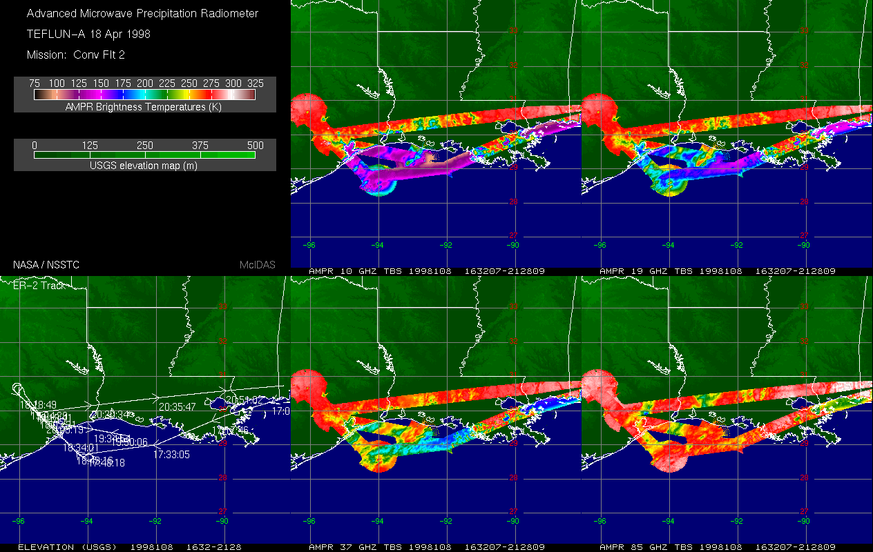
Federal
AMPR TEFLUN-A BRIGHTNESS TEMPERATURE (TB) V1
National Aeronautics and Space Administration —
The Advanced Microwave Precipitation Radiometer (AMPR) was deployed during the Texas-Florida Underflights (TEFLUN-A); the first of three TRMM ground validation... -
Federal
Patent AT-E400701-T1: [Translated] ROADWAY FOR DECLARING AND/OR ACCELERATING A VEHICLE, INCLUDING AN AIRCRAFT
U.S. Department of Health & Human Services —
A method for slowing a vehicle traveling over a movable surface in a direction of travel where the vehicle has a first wheel and at least a second wheel offset from... -
Federal
Defense Office of Hearings & Appeals Decisions- Military Personnel Claim Decisions - 2016
Department of Defense —
Decisions involve claims related to uniformed service members' pay, allowances, travel, transportation, retired pay, and survivor benefits -
Federal
GPM GROUND VALIDATION DUAL-FREQUENCY DUAL-POLARIZED DOPPLER RADAR (D3R) GCPEX
National Aeronautics and Space Administration —
The GPM Ground Validation Dual-frequency Dual-polarized Doppler Radar (D3R) GCPEx and IFloodS data sets contain radar reflectivity and doppler velocity measurements.... -
Federal
Hitomi Master Catalog
National Aeronautics and Space Administration —
This table records high-level information for the observations obtained with Hitomi and provides access to the data archive. The Hitomi mission was launched on a JAXA... -
State
Tree Habitat - Spears and Didion Ranches [ds321]
State of California —
These data are the summary statistics calculated for trees and snags from the three 0.05-ha circular plot habitat samples taken in 2005 each at the 15 sample points... -
State
Bedrock Geologic Map of the Lincoln Quadrangle, Vermont
Vermont Center for Geographic Information —
Digital Data from VG95-5A Stanley, R, DelloRusso, V, Haydock, S, Lapp, E, O'Loughlin, S, Prewitt, J,and Tauvers, PR, 1995, Digital compilation bedrock geologic map of... -
Federal
NOAA/WDS Paleoclimatology - Schweingruber - Verhnaja Toima - PISY - ITRDB RUSS051
National Oceanic and Atmospheric Administration, Department of Commerce —
This archived Paleoclimatology Study is available from the NOAA National Centers for Environmental Information (NCEI), under the World Data Service (WDS) for... -
Federal
NOAA/WDS Paleoclimatology - King - Norris Upland - PICO - ITRDB WY051
National Oceanic and Atmospheric Administration, Department of Commerce —
This archived Paleoclimatology Study is available from the NOAA National Centers for Environmental Information (NCEI), under the World Data Service (WDS) for... -
Federal
NOAA/WDS Paleoclimatology - Veblen fire data from BM15 - IMPD USBM-015
National Oceanic and Atmospheric Administration, Department of Commerce —
This archived Paleoclimatology Study is available from the NOAA National Centers for Environmental Information (NCEI), under the World Data Service (WDS) for... -
Federal
NOAA/WDS Paleoclimatology - Boninsegna - Puerto Parry - NOBE - ITRDB ARGE051
National Oceanic and Atmospheric Administration, Department of Commerce —
This archived Paleoclimatology Study is available from the NOAA National Centers for Environmental Information (NCEI), under the World Data Service (WDS) for... -
Federal
PNG format images of EdgeTech SB-512i chirp seismic-reflection data collected in May 2012 by the U.S. Geological Survey within the Washington Canyon, mid-Atlantic Margin
Department of the Interior —
A large number of high-resolution geophysical surveys between Cape Hatteras and Georges Bank have been conducted by federal, state, and academic institutions since... -
Federal
JPEG images of seismic data collected off the southern shore of Martha's Vineyard, MA, 2007
Department of the Interior —
The USGS Woods Hole Science Center conducted a nearshore geophysical survey offshore of the southern coast of Martha's Vineyard, in the vicinity of the Martha's... -
Federal
Beach topography and near-shore bathymetry of Lake Superior at Minnesota Point near the Superior Entry, Duluth, MN, September 2022
Department of the Interior —
These data are digital elevation models (DEMs) of the beach topography and near-shore bathymetry of Lake Superior at Minnesota Point, near the Superior entry, Duluth,...

Official websites use .gov
A
.gov website belongs to an official government
organization in the United States.
Secure .gov websites use HTTPS
A
lock (
) or https:// means you’ve safely connected to
the .gov website. Share sensitive information only on official,
secure websites.