
-
Federal
Georeferenced Population Datasets of Mexico (GEO-MEX): GIS of Mexican States, Municipalities and Islands
National Aeronautics and Space Administration —
The GIS of Mexican States, Municipalities and Islands consists of attribute and boundary data for 1990. The attribute data include population, language, education,... -
Federal
Georeferenced Population Datasets of Mexico (GEO-MEX): Urban Place GIS Coverage of Mexico
National Aeronautics and Space Administration —
The Urban Place GIS Coverage of Mexico is a vector based point Geographic Information System (GIS) coverage of 696 urban places in Mexico. Each Urban Place is... -
Federal
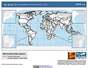
Gridded Population of the World, Version 4 (GPWv4): Population Count, Revision 11
National Aeronautics and Space Administration —
The Gridded Population of the World, Version 4 (GPWv4): Population Count, Revision 11 consists of estimates of human population (number of persons per pixel),... -
Federal
Global Rural-Urban Mapping Project, Version 1 (GRUMPv1): Urban Extents Grid
National Aeronautics and Space Administration —
The Global Rural-Urban Mapping Project, Version 1 (GRUMPv1): Urban Extents Grid distinguishes urban and rural areas based on a combination of population counts... -
Federal
China Dimensions Data Collection: China County-Level Data on Population (Census) and Agriculture, Keyed to 1:1M GIS Map
National Aeronautics and Space Administration —
The China County-Level Data on Population (Census) and Agriculture, Keyed To 1:1M GIS Map consists of census, agricultural economic, and boundary data for the... -
Federal
Georeferenced U.S. County-Level Population Projections, Total and by Sex, Race and Age, Based on the SSPs, 2020-2100
National Aeronautics and Space Administration —
The Georeferenced U.S. County-Level Population Projections, Total and by Sex, Race and Age, Based on the SSPs, 2020-2100 consists of county-level population... -
Federal
Gridded Population of the World, Version 4 (GPWv4): Population Density, Revision 11
National Aeronautics and Space Administration —
The Gridded Population of the World, Version 4 (GPWv4): Population Density, Revision 11 consists of estimates of human population density (number of persons per... -
Federal
Poverty Mapping Project: Global Subnational Prevalence of Child Malnutrition
National Aeronautics and Space Administration —
The Poverty Mapping Project: Global Subnational Prevalence of Child Malnutrition data set consists of estimates of the percentage of children with weight-for-age... -
Federal
Spatial Data from the 2011 India Census
National Aeronautics and Space Administration —
The Spatial Data from the 2011 India Census contains gridded estimates of India population at a resolution of 1 kilometer along with two spatial renderings of urban... -
Federal
Global Urban Polygons and Points Dataset (GUPPD), Version 1
National Aeronautics and Space Administration —
The Global Urban Polygons and Points Dataset (GUPPD), Version 1 is a global data set of 123,034 urban settlements with place names and population for the years... -
Federal
Global Population Density Grid Time Series Estimates
National Aeronautics and Space Administration —
The Global Population Density Grid Time Series Estimates provide a back-cast time series of population density grids based on the year 2000 population grid from... -
Federal
Global 15 x 15 Minute Grids of the Downscaled GDP Based on the SRES B2 Scenario, 1990 and 2025
National Aeronautics and Space Administration —
The Global 15x15 Minute Grids of the Downscaled GDP Based on the Special Report on Emissions Scenarios (SRES) B2 Scenario, 1990 and 2025, are geospatial distributions... -
Federal
Global Human Settlement Layer: Population and Built-Up Estimates, and Degree of Urbanization Settlement Model Grid
National Aeronautics and Space Administration —
The Global Human Settlement Layer: Population and Built-Up Estimates, and Degree of Urbanization Settlement Model Grid data set provides gridded data on human... -
Federal
SDG Indicator 7.1.1: Access to Electricity, 2023 Release
National Aeronautics and Space Administration —
The SDG Indicator 7.1.1: Access to Electricity, 2023 Release data set, part of the Sustainable Development Goal Indicators (SDGI) collection, measures the proportion... -
Federal
SDG Indicator 11.2.1: Urban Access to Public Transport, 2023 Release
National Aeronautics and Space Administration —
The SDG Indicator 11.2.1: Urban Access to Public Transport, 2023 Release, part of the SDGI collection, measures the proportion of the population in a city that has... -
Federal
Archive of Census Related Products (ACRP): 1990 Census Block Statistics
National Aeronautics and Space Administration —
The 1990 Census Block Statistics portion of the Archive of Census Related Products (ACRP) contains population and housing data from the U.S. Census Bureau's 1990... -
Federal
Gridded Population of the World, Version 3 (GPWv3): Subnational Administrative Boundaries
National Aeronautics and Space Administration —
The Gridded Population of the World, Version 3 (GPWv3): Subnational Administrative Boundaries are the basis of the population data products in GPWv3. Due to copyright... -
Federal
China Dimensions Data Collection: China County-Level Data from Provincial Economic Yearbooks, Keyed to 1:1M GIS Map
National Aeronautics and Space Administration —
The China County-Level Data on Provincial Economic Yearbooks, Keyed To 1:1M GIS Map consists of socioeconomic and boundary data for the administrative regions of... -
Federal
Historical Urban Population: 3700 BC - AD 2000
National Aeronautics and Space Administration —
The Historical Urban Population, 3700 BC - AD 2000, originally developed by the Yale School of Forestry & Environmental Studies, is the first spatially explicit... -
Federal
China Dimensions Data Collection: Fundamental GIS: Digital Chart of China, 1:1M, Version 1
National Aeronautics and Space Administration —
The Fundamental GIS: Digital Chart of China, 1:1M, Version 1 consists of vector maps of China and surrounding areas. The maps include roads, railroads, drainage...

Official websites use .gov
A
.gov website belongs to an official government
organization in the United States.
Secure .gov websites use HTTPS
A
lock (
) or https:// means you’ve safely connected to
the .gov website. Share sensitive information only on official,
secure websites.