

10 datasets found for "NRCS"
-
Federal
RapidScat Level 2B Climate Ocean Wind Vectors in 12.5km Footprints Version 2.0
National Aeronautics and Space Administration —
This dataset contains the RapidScat Level 2B 12.5km Version 2.0 Climate quality ocean surface wind vectors. The Level 2B wind vectors are binned on a 12.5 km Wind... -
Federal
RapidScat Level 2B Climate Ocean Wind Vectors in 12.5km Footprints
National Aeronautics and Space Administration —
This dataset contains the RapidScat Level 2B 12.5km Version 1.0 Climate quality ocean surface wind vectors. The Level 2B wind vectors are binned on a 12.5 km Wind... -
Federal
Global Soil Profile Data (ISRIC-WISE)
National Aeronautics and Space Administration —
The International Soil Reference and Information Centre-World Inventory of Soil Emission Potentials (ISRIC-WISE) international soil profile data set consists of a... -
Federal
Aquarius L3 Weekly Polar-Gridded Normalized Radar Cross Section V005
National Aeronautics and Space Administration —
The data set consists of weekly polar-gridded Level-3 products of Aquarius L-band Normalized Radar Cross Section (NRCS) retrievals from the Aquarius/Satélite de... -
Federal
Aquarius L3 Weekly Polar-Gridded Normalized Radar Cross Section V005
National Aeronautics and Space Administration —
The data set consists of weekly polar-gridded Level-3 products of Aquarius L-band Normalized Radar Cross Section (NRCS) retrievals from the Aquarius/Satélite de... -
Federal
SnowEx17 Ground-Based UWScat Ku- and X-Band Frequency Modulated Continuous Wave Radar V001
National Aeronautics and Space Administration —
This data set consists of ground-based scatterometer data acquired during the SnowEx 2017 campaign at Grand Mesa, Colorado, USA, a snow-covered, forested study site... -
Federal
QuikSCAT Level 1C Averaged Sigma-0 and Winds from Non-spinning Antenna Version 2.0
National Aeronautics and Space Administration —
This dataset is Version 2 of the geo-located and averaged Level 1B Sigma-0 measurements and wind retrievals from the SeaWinds on QuikSCAT platform, initiated in the... -
Federal
SWOT Level 2 KaRIn Low Rate Sea Surface Height Data Product - WindWave, Version 2.0
National Aeronautics and Space Administration —
The SWOT Level 2 KaRIn Low Rate Sea Surface Height Windwave Data Product from the Surface Water Ocean Topography (SWOT) mission provides global sea surface height and... -
Federal
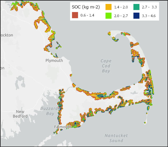
Soil Organic Carbon Distributions in Tidal Wetlands of the Northeastern USA
National Aeronautics and Space Administration —
This dataset provides estimates of soil organic carbon (SOC) in tidal wetlands for the northeastern United States. The data cover the period 1998-2018. Northeastern...
10 datasets found for "NRCS"