Tropical Cyclone PRecipitation, Infrared, Microwave, and Environmental Dataset (TC PRIMED)
Access & Use Information
Downloads & Resources
-
NCEI Dataset Landing Page
Landing page for the dataset.
-
Direct Download (Dataset Files)
Direct download for the dataset.
-
THREDDSHTML
THREDDS Data Server (TDS) for the dataset.
-
NOAA National Centers for Environmental...
NCEI home page with information, data access and contact information.
-
Global Change Master Directory (GCMD) Keywords
The information provided on this page seeks to define how the GCMD Keywords...
-
GCOS Essential Climate Variables
Overview of the GCOS Essential Climate Variables.
-
Global Change Master Directory (GCMD) Keywords
The information provided on this page seeks to define how the GCMD Keywords...
-
Global Change Master Directory (GCMD) Keywords
The information provided on this page seeks to define how the GCMD Keywords...
-
Global Change Master Directory (GCMD) Keywords
The information provided on this page seeks to define how the GCMD Keywords...
-
Global Change Master Directory (GCMD) Keywords
The information provided on this page seeks to define how the GCMD Keywords...
-
Global Change Master Directory (GCMD) Keywords
The information provided on this page seeks to define how the GCMD Keywords...
-
Global Change Master Directory (GCMD) Keywords
The information provided on this page seeks to define how the GCMD Keywords...
-
Global Change Master Directory (GCMD) Keywords
The information provided on this page seeks to define how the GCMD Keywords...
-
Global Change Master Directory (GCMD) Keywords
The information provided on this page seeks to define how the GCMD Keywords...
Dates
| Metadata Date | June 23, 2023 |
|---|---|
| Metadata Created Date | April 28, 2023 |
| Metadata Updated Date | September 19, 2023 |
| Reference Date(s) | April 17, 2023 (publication) |
| Frequency Of Update | monthly |
Metadata Source
- ISO-19139 ISO-19139 Metadata
Harvested from ncdc
Graphic Preview

Additional Metadata
| Resource Type | Dataset |
|---|---|
| Metadata Date | June 23, 2023 |
| Metadata Created Date | April 28, 2023 |
| Metadata Updated Date | September 19, 2023 |
| Reference Date(s) | April 17, 2023 (publication) |
| Responsible Party | NOAA National Centers for Environmental Information (Point of Contact) |
| Contact Email | |
| Guid | gov.noaa.ncdc:C01685 |
| Access Constraints | Cite as: Cite as: Razin, Muhammad Naufal; Slocum, Christopher J.; Knaff, John A.; Brown, Paula J. 2023. Tropical Cyclone PRecipitation, Infrared, Microwave, and Environmental Dataset (TC PRIMED). 1.0. [indicate subset used]. NOAA National Centers for Environmental Information. https://doi.org/10.25921/dmy1-0595. Accessed [date]., Distribution liability: NOAA and NCEI make no warranty, expressed or implied, regarding these data, nor does the fact of distribution constitute such a warranty. NOAA and NCEI cannot assume liability for any damages caused by any errors or omissions in these data. If appropriate, NCEI can only certify that the data it distributes are an authentic copy of the records that were accepted for inclusion in the NCEI archives., Use liability: NOAA and NCEI cannot provide any warranty as to the accuracy, reliability, or completeness of furnished data. Users assume responsibility to determine the usability of these data. The user is responsible for the results of any application of this data for other than its intended purpose. |
| Bbox East Long | 180.0 |
| Bbox North Lat | 90.0 |
| Bbox South Lat | -90.0 |
| Bbox West Long | -180.0 |
| Coupled Resource | |
| Frequency Of Update | monthly |
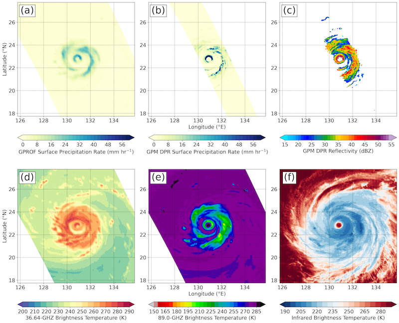
| Graphic Preview Description | A sampling of TC PRIMED products from Typhoon Maria (2018) at 10:13 UTC on 9 July 2018 in the western Pacific, where a) is GPROF, b) is GPM DPR precipitation rate, c) GPM DPR reflectivity, d) 36.6 GHz, e) 89 GHZ, and IR from Himawari-8. |
| Graphic Preview File | https://www.ncei.noaa.gov/pub/data/metadata/images/C01685.png |
| Graphic Preview Type | PNG |
| Harvest Object Id | 6203b251-ff0c-41cf-a8df-8acc6ba6cda6 |
| Harvest Source Id | 2cb3ef77-1683-4c2a-9119-dc65e50917c6 |
| Harvest Source Title | ncdc |
| Licence | The time of satellite passive microwave observations is irregular because it is dependent on fortuitous satellite overpass of a translating tropical cyclone. NASA GPROF precipitation retrieval not based solely on a database of tropical cyclones. Availability of infrared imagery is more scarce earlier in the dataset period and also dependent on the location of the observed tropical cyclone. The resolution of the ERA5 dataset limits the scales at which the model data can be used to interpret processes that control the evolution of tropical cyclones and their associated convection. |
| Lineage | Members of the team have been working with satellite-based passive microwave and precipitation radar data for many years. They have a comprehensive understanding of all the data obtained from NASA's Precipitation Processing System. IR imagery of tropical cyclones were gathered from CIRA and NOAA Center for Satellite Applications and Research Regional and Mesoscale Meteorology Branch, which have been collecting, analyzing, and training on the use of IR imagery of tropical cyclones since 1980. The reanalysis product (ERA5) used to generate the environmental parameters is well documented and the information is readily accessible. The team associated with creating the dataset is intimately knowledgeable about the steps used to post-process the reanalysis product to create the environmental parameters. |
| Metadata Language | eng; USA |
| Metadata Type | geospatial |
| Old Spatial | {"type": "Polygon", "coordinates": [[[-180.0, -90.0], [180.0, -90.0], [180.0, 90.0], [-180.0, 90.0], [-180.0, -90.0]]]} |
| Progress | onGoing |
| Spatial Data Service Type | |
| Spatial Reference System | |
| Spatial Harvester | True |
| Temporal Extent Begin | 1997-12 |
Didn't find what you're looking for? Suggest a dataset here.

