MODIS-based GPP, PAR, fC4, and SANIRv estimates from SLOPE for CONUS, 2000-2019
Access & Use Information
Downloads & Resources
-
Google Scholar search resultsHTML
Search results for publications that cite this dataset by its DOI.
-
Download this datasetHTML
This link allows direct data access via Earthdata login
-
View documentation related to this datasetHTML
ORNL DAAC Data Set Documentation
-
This dataset's landing pageHTML
Data set Landing Page DOI URL
-
View documentation related to this datasetZIP
MODIS-based GPP, PAR, fC4, and SANIRv estimates from SLOPE for CONUS,...
-
View documentation related to this datasetPDF
MODIS-based GPP, PAR, fC4, and SANIRv estimates from SLOPE for CONUS,...
-
Get a related visualizationPNG
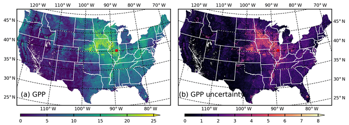
Spatial distribution of (a) GPP (gC m2/d) and (b) GPP uncertainty (gC m2/d)...
-
Landing PageLanding Page
Dates
| Metadata Created Date | December 1, 2022 |
|---|---|
| Metadata Updated Date | December 7, 2023 |
Metadata Source
- Data.json Data.json Metadata
Harvested from NASA Data.json
Graphic Preview

Additional Metadata
| Resource Type | Dataset |
|---|---|
| Metadata Created Date | December 1, 2022 |
| Metadata Updated Date | December 7, 2023 |
| Publisher | ORNL_DAAC |
| Maintainer | |
| Identifier | C2266194621-ORNL_CLOUD |
| Data First Published | 2021-11-13 |
| Language | en-US |
| Data Last Modified | 2023-06-12 |
| Category | CMS, geospatial |
| Public Access Level | public |
| Bureau Code | 026:00 |
| Metadata Context | https://project-open-data.cio.gov/v1.1/schema/catalog.jsonld |
| Metadata Catalog ID | https://data.nasa.gov/data.json |
| Schema Version | https://project-open-data.cio.gov/v1.1/schema |
| Catalog Describedby | https://project-open-data.cio.gov/v1.1/schema/catalog.json |
| Citation | Jiang, C., and K. Guan. 2020. MODIS-based GPP, PAR, fC4, and SANIRv estimates from SLOPE for CONUS, 2000-2019. ORNL DAAC, Oak Ridge, Tennessee, USA. https://doi.org/10.3334/ORNLDAAC/1786 |
| Graphic Preview Description | Spatial distribution of (a) GPP (gC m2/d) and (b) GPP uncertainty (gC m2/d) across the CONUS at 250-m resolution for 10 July 2020 (image source: Jiang et al. 2021). |
| Graphic Preview File | https://daac.ornl.gov/CMS/guides/SLOPE_GPP_CONUS_Fig1.png |
| Harvest Object Id | 26e2e870-c0c0-4817-ad5f-91bf1cae3850 |
| Harvest Source Id | 58f92550-7a01-4f00-b1b2-8dc953bd598f |
| Harvest Source Title | NASA Data.json |
| Homepage URL | https://doi.org/10.3334/ORNLDAAC/1786 |
| Metadata Type | geospatial |
| Old Spatial | -155.57 19.99 -52.22 50.01 |
| Program Code | 026:001 |
| Source Datajson Identifier | True |
| Source Hash | da9b1d3f57535fd5ab68ef08f1c05329ddd613fc55a6162685296c495a616ec1 |
| Source Schema Version | 1.1 |
| Spatial | |
| Temporal | 2000-01-01T00:00:00Z/2020-01-01T23:59:59Z |
Didn't find what you're looking for? Suggest a dataset here.

