MASTER: HyspIRI Airborne Campaign, California, Fall 2013
Access & Use Information
Downloads & Resources
-
Google Scholar search resultsHTML
Search results for publications that cite this dataset by its DOI.
-
Download this datasetHTML
This link allows direct data access via Earthdata login
-
View documentation related to this datasetHTML
ORNL DAAC Data Set Documentation
-
This dataset's landing pageHTML
Data set Landing Page DOI URL
-
View documentation related to this datasetPDF
MASTER: HyspIRI Airborne Campaign, California, Fall 2013:...
-
Get a related visualizationJPEG
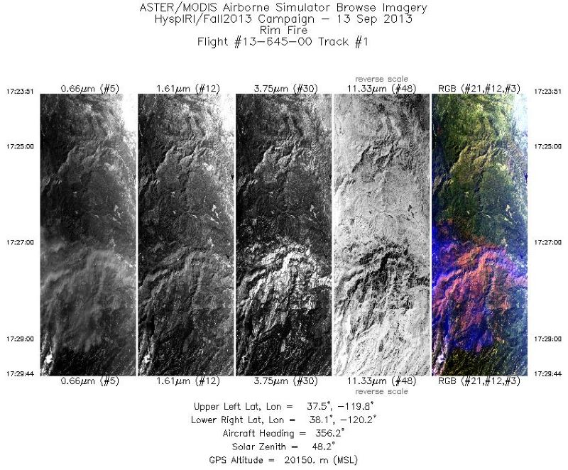
Single band images and an RGB composite image from flight track 1 acquired on...
-
Landing PageLanding Page
Dates
| Metadata Created Date | July 27, 2023 |
|---|---|
| Metadata Updated Date | December 7, 2023 |
Metadata Source
- Data.json Data.json Metadata
Harvested from NASA Data.json
Graphic Preview

Additional Metadata
| Resource Type | Dataset |
|---|---|
| Metadata Created Date | July 27, 2023 |
| Metadata Updated Date | December 7, 2023 |
| Publisher | ORNL_DAAC |
| Maintainer | |
| Identifier | C2731688788-ORNL_CLOUD |
| Data First Published | 2023-07-08 |
| Language | en-US |
| Data Last Modified | 2023-07-13 |
| Category | MASTER, HyspIRI Airborne, geospatial |
| Public Access Level | public |
| Bureau Code | 026:00 |
| Metadata Context | https://project-open-data.cio.gov/v1.1/schema/catalog.jsonld |
| Metadata Catalog ID | https://data.nasa.gov/data.json |
| Schema Version | https://project-open-data.cio.gov/v1.1/schema |
| Catalog Describedby | https://project-open-data.cio.gov/v1.1/schema/catalog.json |
| Citation | Hook, S.J., J.S. Myers, K.J. Thome, M. Fitzgerald, A.B. Kahle, Airborne Sensor Facility NASA Ames Research Center, R.O. Green, and B. Cairns. 2022. MASTER: HyspIRI Airborne Campaign, California, Fall 2013. ORNL DAAC, Oak Ridge, Tennessee, USA. https://doi.org/10.3334/ORNLDAAC/1966 |
| Graphic Preview Description | Single band images and an RGB composite image from flight track 1 acquired on 13 September 2013 over the Rim Fire scar at Yosemite National Park, California, U.S. Source: MASTERL1B_1364500_01_20130913_1723_1729_V03.jpg |
| Graphic Preview File | https://daac.ornl.gov/MASTER/guides/MASTER_HyspIRI_Fall_2013_Fig1.jpg |
| Harvest Object Id | c0a39388-1e33-4ac6-88d3-bc86db71dfd5 |
| Harvest Source Id | 58f92550-7a01-4f00-b1b2-8dc953bd598f |
| Harvest Source Title | NASA Data.json |
| Homepage URL | https://doi.org/10.3334/ORNLDAAC/1966 |
| Metadata Type | geospatial |
| Old Spatial | -123.75 31.95 -112.5 40.98 |
| Program Code | 026:001 |
| Source Datajson Identifier | True |
| Source Hash | a6e894fae9f2305eecc2db31481f9f0f234b3f767e846a73210bd3089ac09be5 |
| Source Schema Version | 1.1 |
| Spatial | |
| Temporal | 2013-09-13T17:23:51Z/2013-12-05T21:22:39Z |
Didn't find what you're looking for? Suggest a dataset here.

